Arvada Topo Map Colorado
To zoom in, hover over the map of Arvada
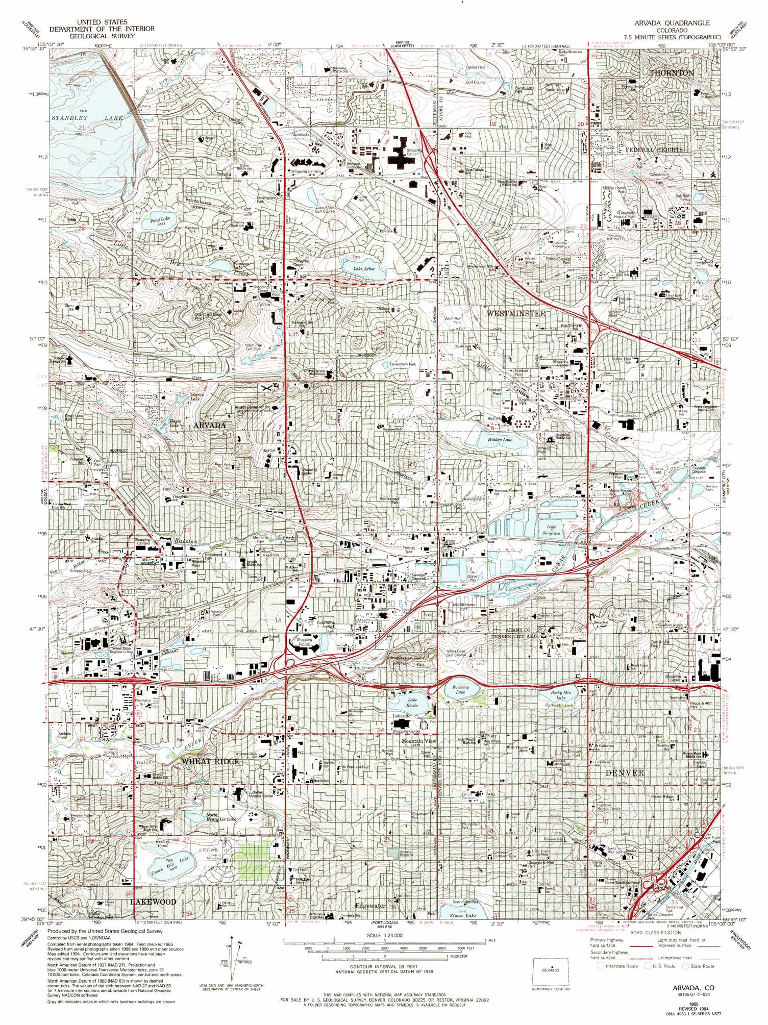
USGS Topo Quad 39105g1 - 1:24,000 scale
| Topo Map Name: | Arvada |
| USGS Topo Quad ID: | 39105g1 |
| Print Size: | ca. 21 1/4" wide x 27" high |
| Southeast Coordinates: | 39.75° N latitude / 105° W longitude |
| Map Center Coordinates: | 39.8125° N latitude / 105.0625° W longitude |
| U.S. State: | CO |
| Filename: | o39105g1.jpg |
| Download Map JPG Image: | Arvada topo map 1:24,000 scale |
| Map Type: | Topographic |
| Topo Series: | 7.5´ |
| Map Scale: | 1:24,000 |
| Source of Map Images: | United States Geological Survey (USGS) |
| Alternate Map Versions: |
Arvada CO 1950 Download PDF Buy paper map Arvada CO 1957, updated 1958 Download PDF Buy paper map Arvada CO 1957, updated 1958 Download PDF Buy paper map Arvada CO 1957, updated 1963 Download PDF Buy paper map Arvada CO 1965, updated 1967 Download PDF Buy paper map Arvada CO 1965, updated 1969 Download PDF Buy paper map Arvada CO 1965, updated 1973 Download PDF Buy paper map Arvada CO 1965, updated 1973 Download PDF Buy paper map Arvada CO 1965, updated 1980 Download PDF Buy paper map Arvada CO 1965, updated 1994 Download PDF Buy paper map Arvada CO 2011 Download PDF Buy paper map Arvada CO 2013 Download PDF Buy paper map Arvada CO 2016 Download PDF Buy paper map |
1:24,000 Topo Quads surrounding Arvada
Boulder |
Niwot |
Erie |
Frederick |
Fort Lupton |
Eldorado Springs |
Louisville |
Lafayette |
Eastlake |
Brighton |
Ralston Buttes |
Golden |
Arvada |
Commerce City |
Sable |
Evergreen |
Morrison |
Fort Logan |
Englewood |
Fitzsimons |
Conifer |
Indian Hills |
Littleton |
Highlands Ranch |
Parker |
> Back to 39105e1 at 1:100,000 scale
> Back to 39104a1 at 1:250,000 scale
> Back to U.S. Topo Maps home
Arvada topo map: Gazetteer
Arvada: Airports
Exempla Lutheran Medical Center Heliport elevation 1679m 5508′Public Service of Colorado Arvada Heliport elevation 1617m 5305′
Saint Anthony North Heliport elevation 1681m 5515′
SF Heliport elevation 1615m 5298′
Arvada: Canals
Allen Ditch elevation 1662m 5452′Crown Hill Ditch elevation 1701m 5580′
Fisher Ditch elevation 1592m 5223′
Juchem Ditch elevation 1639m 5377′
Kershaw Ditch elevation 1592m 5223′
Niver Canal elevation 1659m 5442′
Arvada: Crossings
Exit 1A elevation 1616m 5301′Exit 1B elevation 1601m 5252′
Exit 267 elevation 1637m 5370′
Exit 269A elevation 1625m 5331′
Exit 269B elevation 1617m 5305′
Exit 270 elevation 1632m 5354′
Exit 271A elevation 1635m 5364′
Exit 271B elevation 1641m 5383′
Exit 272 elevation 1640m 5380′
Exit 273 elevation 1601m 5252′
Exit 3 elevation 1592m 5223′
Arvada: Dams
Crown Hill Cemetery Dam elevation 1695m 5561′Kalcevic Dam elevation 1630m 5347′
Oberon Lake Number 1 Dam elevation 1661m 5449′
Pomona Lake Number 1 Dam elevation 1681m 5515′
Pomona Number 2 and 3 Dam elevation 1665m 5462′
Standley Lake Dam elevation 1680m 5511′
Tepper Number 1 Dam elevation 1641m 5383′
Arvada: Lakes
Berkeley Lake elevation 1630m 5347′Crown Hill Lake elevation 1695m 5561′
Kestrel Pond elevation 1696m 5564′
Lake Rhoda elevation 1630m 5347′
Mayham Lake elevation 1611m 5285′
Rocky Mountain Lake elevation 1636m 5367′
Arvada: Mines
Asphalt Paving Company Pit elevation 1600m 5249′Asphalt Paving Company Pit elevation 1600m 5249′
Brannan Sand and Gravel Company Pit elevation 1588m 5209′
Brannan Sand and Gravel Company Pit elevation 1586m 5203′
Brannan Sand and Gravel Company Pit elevation 1584m 5196′
Colorado-Wyoming Improvement Company Pit elevation 1588m 5209′
Colorado-Wyoming Improvement Company Pit elevation 1580m 5183′
Cooley Gravel Company Pit elevation 1598m 5242′
Cooley Gravel Company Pit elevation 1595m 5232′
Cooley Sand and Gravel Company Pit elevation 1585m 5200′
Cooley Sand and Gravel Company Pit elevation 1596m 5236′
Cooley Sand and Gravel Pit elevation 1594m 5229′
Western Paving Company Pit elevation 1594m 5229′
Western Paving Company Pit elevation 1589m 5213′
Arvada: Parks
Allendale Park elevation 1653m 5423′Anderson Park elevation 1629m 5344′
Apel-Bacher Park elevation 1645m 5396′
Arvada Tennis Center elevation 1642m 5387′
Berkeley Hills Park elevation 1625m 5331′
Berkeley Park elevation 1638m 5374′
Bishop Square Park elevation 1667m 5469′
Carmenisch Park elevation 1640m 5380′
Carol Butts Park elevation 1659m 5442′
Centennial Park elevation 1580m 5183′
Chaffee Park elevation 1611m 5285′
Club Crest North Park elevation 1687m 5534′
Club Crest Park elevation 1704m 5590′
Cobblestone Park elevation 1657m 5436′
Columbine Park elevation 1612m 5288′
Columbus Park elevation 1598m 5242′
Confluence Park elevation 1580m 5183′
Crown Hill Park elevation 1695m 5561′
D A V Park elevation 1615m 5298′
Davis Lane Park elevation 1650m 5413′
Dover Square Park elevation 1684m 5524′
England Park elevation 1609m 5278′
Far Horizon Park elevation 1644m 5393′
Faversham Park elevation 1640m 5380′
Fireman Park elevation 1619m 5311′
Fitzmorris Park elevation 1640m 5380′
Foster Park elevation 1615m 5298′
Fruitdale Park elevation 1638m 5374′
Gates Crescent Park elevation 1584m 5196′
Hackberry Park elevation 1659m 5442′
Harold D Lutz Sports Complex elevation 1642m 5387′
Highland Park elevation 1635m 5364′
Highland Park Historical District elevation 1620m 5314′
Hillside Park elevation 1651m 5416′
Hirshorn Park elevation 1606m 5269′
Homestead Park elevation 1625m 5331′
Hoskinson Park elevation 1626m 5334′
Independence Park elevation 1655m 5429′
Jefferson Park elevation 1604m 5262′
Johnson Park elevation 1617m 5305′
Johnson Park elevation 1619m 5311′
Kennedy Park elevation 1620m 5314′
King Mill Park elevation 1684m 5524′
Ladybug Park elevation 1664m 5459′
Lake Arbor Park elevation 1643m 5390′
Lake Side Amusement Park elevation 1634m 5360′
Lakecrest Park elevation 1686m 5531′
Lew Walsh Park elevation 1644m 5393′
Lewis Ralston Gold Site Park elevation 1604m 5262′
Little Dry Creek Lake Park elevation 1586m 5203′
Little Dry Creek Park elevation 1637m 5370′
Louise Turner Park elevation 1648m 5406′
Lowell Street Park elevation 1596m 5236′
Majestic View Park elevation 1687m 5534′
Maulis Park elevation 1659m 5442′
McDonough Park elevation 1634m 5360′
McIlvoy Park elevation 1624m 5328′
Memorial Park elevation 1621m 5318′
Metz Park elevation 1652m 5419′
Municipal Court Park elevation 1638m 5374′
Nottingham Park elevation 1673m 5488′
Oak Park elevation 1709m 5606′
Oakhurst Park elevation 1659m 5442′
Oakwood Park elevation 1658m 5439′
Osceola And 29th Park elevation 1637m 5370′
Panorama Park elevation 1667m 5469′
Paramount Park elevation 1698m 5570′
Pecos And 46th Park elevation 1602m 5255′
Pecos Park elevation 1638m 5374′
Pferdsteller Park elevation 1671m 5482′
Potter Highlands Historic District elevation 1627m 5337′
Prospect Park elevation 1644m 5393′
Rainbow II Park elevation 1669m 5475′
Rainbow III Park elevation 1666m 5465′
Rainbow Park elevation 1680m 5511′
Ralston Cove Park elevation 1632m 5354′
Randall Park elevation 1644m 5393′
River Front Park elevation 1576m 5170′
Rocky Mountain Park elevation 1637m 5370′
Secrest Park elevation 1648m 5406′
Sierra Park elevation 1721m 5646′
Skyline Vista Park elevation 1615m 5298′
Sloans Lake Park elevation 1622m 5321′
Stites Park elevation 1660m 5446′
Stonemen's Row Historic District elevation 1598m 5242′
Sunrise Park elevation 1629m 5344′
Sunset Park elevation 1632m 5354′
Tennyson Knolls Park elevation 1614m 5295′
Tennyson Park elevation 1647m 5403′
Terrace Park elevation 1634m 5360′
Thundercloud Park elevation 1704m 5590′
Tomlinson Park elevation 1631m 5351′
Two Ponds National Wildlife Refuge elevation 1679m 5508′
Westbrook Park elevation 1644m 5393′
Westree Park elevation 1674m 5492′
Wolff Run Park elevation 1628m 5341′
Woodrun Park elevation 1684m 5524′
Zuni And 51st Park elevation 1627m 5337′
Arvada: Populated Places
Alta Vista elevation 1633m 5357′Arvada elevation 1629m 5344′
Berkeley Gardens elevation 1612m 5288′
Berkley elevation 1589m 5213′
Bridle Dale elevation 1699m 5574′
Cambridge Park elevation 1639m 5377′
Churchhill Downs elevation 1710m 5610′
Club Crest elevation 1707m 5600′
Columbine Acres elevation 1612m 5288′
Edgewater elevation 1640m 5380′
Fairview elevation 1634m 5360′
Far Horizon elevation 1649m 5410′
Green Valley elevation 1626m 5334′
Hackberry Hills elevation 1680m 5511′
Happy Valley Gardens elevation 1632m 5354′
Harris Park elevation 1625m 5331′
Hidden Creek Park elevation 1642m 5387′
Hidden Lake elevation 1614m 5295′
Highland Gardens elevation 1657m 5436′
Highland Park elevation 1620m 5314′
Hillcrest Heights elevation 1643m 5390′
Holiday Hills Village elevation 1631m 5351′
Homestead Heights elevation 1667m 5469′
Huntington Heights elevation 1712m 5616′
Kimberly Hills elevation 1654m 5426′
Koldeway elevation 1634m 5360′
Lake Arbor elevation 1660m 5446′
Lakecrest elevation 1699m 5574′
Lakeside elevation 1635m 5364′
Lakeside elevation 1635m 5364′
Lakeview elevation 1639m 5377′
Lakeview Estates elevation 1616m 5301′
Lakeview Meadows elevation 1672m 5485′
Lamar Heights elevation 1639m 5377′
Lamar Heights elevation 1640m 5380′
Lamplighter elevation 1686m 5531′
Lyndale Park elevation 1650m 5413′
Maplewood Acres elevation 1655m 5429′
Melrose elevation 1657m 5436′
Mountain View elevation 1641m 5383′
North Green Valley elevation 1631m 5351′
Oak Park elevation 1718m 5636′
Oberon Acres elevation 1714m 5623′
Olinger Gardens elevation 1647m 5403′
Paradise Acres elevation 1699m 5574′
Paramount Heights elevation 1704m 5590′
Park Slope elevation 1624m 5328′
Parkway Estates elevation 1662m 5452′
Pioneer Mobile Gardens elevation 1587m 5206′
Rolling Hills elevation 1662m 5452′
Scenic Heights elevation 1657m 5436′
Semper elevation 1658m 5439′
Shaw Heights elevation 1661m 5449′
Sherrelwood elevation 1613m 5291′
Sherrelwood Estates elevation 1644m 5393′
Sierra Estates elevation 1705m 5593′
Sierra Vista elevation 1715m 5626′
Skyline Estates elevation 1669m 5475′
Skyline Vista elevation 1621m 5318′
Sunland elevation 1657m 5436′
Sunset Ridge elevation 1673m 5488′
Sunstream elevation 1654m 5426′
Tennyson Park elevation 1618m 5308′
The Highlands elevation 1666m 5465′
The Pond elevation 1683m 5521′
Twin Lakes elevation 1599m 5246′
Wellington Downs elevation 1620m 5314′
Westhaven elevation 1657m 5436′
Westminster elevation 1641m 5383′
Westminster Hills elevation 1648m 5406′
Wheat Ridge elevation 1664m 5459′
Wildwood elevation 1647m 5403′
Wood Creek elevation 1634m 5360′
Wood Run elevation 1684m 5524′
Zuni elevation 1587m 5206′
Arvada: Post Offices
Alcott Station Denver Post Office elevation 1656m 5433′Arvada Post Office elevation 1628m 5341′
Indian Tree Station Arvada Post Office elevation 1665m 5462′
Sunnyside Station Denver Post Office elevation 1602m 5255′
Wheat Ridge Post Office elevation 1653m 5423′
Arvada: Reservoirs
Ashland Reservoir elevation 1649m 5410′Bates Lake elevation 1625m 5331′
Calkins Lake elevation 1674m 5492′
Crown Hill Lake elevation 1695m 5561′
Garrison Lake elevation 1628m 5341′
Gordon Lake elevation 1579m 5180′
Kalcevic Reservoir elevation 1630m 5347′
Lake Arbor elevation 1639m 5377′
Lake Rhoda elevation 1630m 5347′
Lake Sangraco elevation 1590m 5216′
North Henry Lee Reservoir elevation 1682m 5518′
Oberon Lake Number 1 elevation 1661m 5449′
Oberon Lakes elevation 1667m 5469′
Pomona Lake elevation 1682m 5518′
Pomona Lake Number 1 elevation 1681m 5515′
Pomona Lake Number 2 elevation 1665m 5462′
Standley Lake elevation 1680m 5511′
Tepper Reservoir Number 1 elevation 1641m 5383′
Walter Long Reservoir elevation 1587m 5206′
Arvada: Streams
Cherry Creek elevation 1580m 5183′Leyden Creek elevation 1649m 5410′
Little Dry Creek elevation 1582m 5190′
Ralston Creek elevation 1600m 5249′
Van Bibber Creek elevation 1629m 5344′
Arvada: Summits
Inspiration Point elevation 1651m 5416′Arvada: Valleys
Lena Gulch elevation 1630m 5347′Arvada digital topo map on disk
Buy this Arvada topo map showing relief, roads, GPS coordinates and other geographical features, as a high-resolution digital map file on DVD: