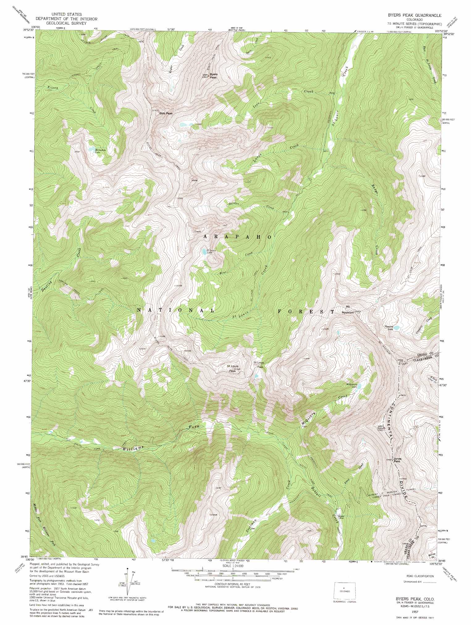
Byers Peak Topo Map Colorado
To zoom in, hover over the map of Byers Peak
USGS Topo Quad 39105g8 - 1:24,000 scale
| Topo Map Name: | Byers Peak |
| USGS Topo Quad ID: | 39105g8 |
| Print Size: | ca. 21 1/4" wide x 27" high |
| Southeast Coordinates: | 39.75° N latitude / 105.875° W longitude |
| Map Center Coordinates: | 39.8125° N latitude / 105.9375° W longitude |
| U.S. State: | CO |
| Filename: | o39105g8.jpg |
| Download Map JPG Image: | Byers Peak topo map 1:24,000 scale |
| Map Type: | Topographic |
| Topo Series: | 7.5´ |
| Map Scale: | 1:24,000 |
| Source of Map Images: | United States Geological Survey (USGS) |
| Alternate Map Versions: |
Byers Peak CO 1957, updated 1959 Download PDF Buy paper map Byers Peak CO 1957, updated 1959 Download PDF Buy paper map Byers Peak CO 1957, updated 1963 Download PDF Buy paper map Byers Peak CO 1957, updated 1974 Download PDF Buy paper map Byers Peak CO 1957, updated 1980 Download PDF Buy paper map Byers Peak CO 1957, updated 1980 Download PDF Buy paper map Byers Peak CO 2011 Download PDF Buy paper map Byers Peak CO 2013 Download PDF Buy paper map Byers Peak CO 2016 Download PDF Buy paper map |
| FStopo: | US Forest Service topo Byers Peak is available: Download FStopo PDF Download FStopo TIF |
1:24,000 Topo Quads surrounding Byers Peak
Parshall |
Hot Sulpher Springs |
Granby |
Strawberry Lake |
Monarch Lake |
Battle Mountain |
Sylvan Reservoir |
Bottle Pass |
Fraser |
East Portal |
Squaw Creek |
Ute Peak |
Byers Peak |
Berthoud Pass |
Empire |
Willow Lakes |
Dillon |
Loveland Pass |
Grays Peak |
Georgetown |
Vail Pass |
Frisco |
Keystone |
Montezuma |
Mount Evans |
> Back to 39105e1 at 1:100,000 scale
> Back to 39104a1 at 1:250,000 scale
> Back to U.S. Topo Maps home
Byers Peak topo map: Gazetteer
Byers Peak: Gaps
Jones Pass elevation 3796m 12454′Saint Louis Pass elevation 3518m 11541′
Byers Peak: Lakes
Horseshoe Lake elevation 3426m 11240′McQueary Lake elevation 3363m 11033′
Saint Louis Lake elevation 3522m 11555′
Vasquez Lake elevation 3594m 11791′
Byers Peak: Mines
Bobtail Mine elevation 3180m 10433′Byers Peak: Parks
Fraser Experimental Forest elevation 2922m 9586′Byers Peak: Streams
Bobtail Creek elevation 3023m 9917′Gordon Creek elevation 3018m 9901′
Iron Creek elevation 2877m 9438′
Jones Creek elevation 3134m 10282′
Lunch Creek elevation 2912m 9553′
McQueary Creek elevation 3023m 9917′
Mine Creek elevation 3060m 10039′
Range Creek elevation 2924m 9593′
Steelman Creek elevation 3016m 9895′
Byers Peak: Summits
Bills Peak elevation 3847m 12621′Byers Peak elevation 3906m 12814′
Mount Nystrom elevation 3856m 12650′
Saint Louis Peak elevation 3736m 12257′
Byers Peak: Trails
Byers Peak Trail elevation 3740m 12270′Darling Creek Trail elevation 3128m 10262′
Kinney Creek Trail elevation 3300m 10826′
Saint Louis Trail elevation 3689m 12103′
Byers Peak: Tunnels
August P Gumlick Tunnel elevation 3605m 11827′Byers Peak digital topo map on disk
Buy this Byers Peak topo map showing relief, roads, GPS coordinates and other geographical features, as a high-resolution digital map file on DVD: