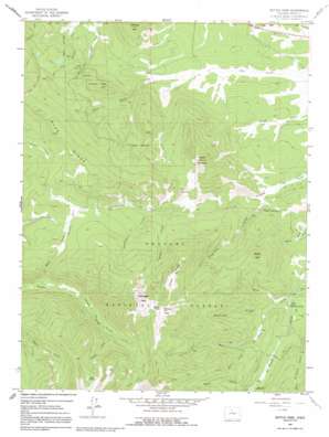
Bottle Pass Topo Map Colorado
To zoom in, hover over the map of Bottle Pass
USGS Topo Quad 39105h8 - 1:24,000 scale
| Topo Map Name: | Bottle Pass |
| USGS Topo Quad ID: | 39105h8 |
| Print Size: | ca. 21 1/4" wide x 27" high |
| Southeast Coordinates: | 39.875° N latitude / 105.875° W longitude |
| Map Center Coordinates: | 39.9375° N latitude / 105.9375° W longitude |
| U.S. State: | CO |
| Filename: | o39105h8.jpg |
| Download Map JPG Image: | Bottle Pass topo map 1:24,000 scale |
| Map Type: | Topographic |
| Topo Series: | 7.5´ |
| Map Scale: | 1:24,000 |
| Source of Map Images: | United States Geological Survey (USGS) |
| Alternate Map Versions: |
Bottle Pass CO 1957, updated 1959 Download PDF Buy paper map Bottle Pass CO 1957, updated 1967 Download PDF Buy paper map Bottle Pass CO 1957, updated 1967 Download PDF Buy paper map Bottle Pass CO 1957, updated 1992 Download PDF Buy paper map Bottle Pass CO 2011 Download PDF Buy paper map Bottle Pass CO 2013 Download PDF Buy paper map Bottle Pass CO 2016 Download PDF Buy paper map |
| FStopo: | US Forest Service topo Bottle Pass is available: Download FStopo PDF Download FStopo TIF |
1:24,000 Topo Quads surrounding Bottle Pass
> Back to 39105e1 at 1:100,000 scale
> Back to 39104a1 at 1:250,000 scale
> Back to U.S. Topo Maps home
Bottle Pass topo map: Gazetteer
Bottle Pass: Canals
Bull Ditch elevation 2829m 9281′Bull Seep elevation 2932m 9619′
Bottle Pass: Cliffs
Rocky Point elevation 2925m 9596′White Cliffs elevation 3154m 10347′
Bottle Pass: Dams
Sinkovits and Linke Dam elevation 2815m 9235′Bottle Pass: Flats
Church Park elevation 3038m 9967′Bottle Pass: Gaps
Bottle Pass elevation 3450m 11318′Bottle Pass: Lakes
Lake Evelyn elevation 3400m 11154′Bottle Pass: Reservoirs
Eastlake Reservoir Number 2 elevation 3168m 10393′Sinkovits and Linke Reservoir elevation 2815m 9235′
Bottle Pass: Ridges
Blue Ridge elevation 3271m 10731′Green Ridge elevation 3386m 11108′
Bottle Pass: Streams
Byers Creek elevation 2851m 9353′Crystal Creek elevation 2800m 9186′
Deadhorse Creek elevation 2802m 9192′
East Saint Louis Creek elevation 2790m 9153′
Evelyn Creek elevation 3015m 9891′
Fool Creek elevation 2765m 9071′
Hull Creek elevation 2862m 9389′
Ptarmigan Creek elevation 2827m 9274′
Short Creek elevation 2865m 9399′
Spruce Creek elevation 2775m 9104′
Tipperary Creek elevation 2671m 8763′
Bottle Pass: Summits
Bottle Peak elevation 3530m 11581′Morse Mountain elevation 3007m 9865′
Ninemile Mountain elevation 2955m 9694′
Ptarmigan Peak elevation 3588m 11771′
Sheep Mountain elevation 3239m 10626′
Bottle Pass: Trails
Horseshoe and Idlewild Trail elevation 2879m 9445′Bottle Pass digital topo map on disk
Buy this Bottle Pass topo map showing relief, roads, GPS coordinates and other geographical features, as a high-resolution digital map file on DVD:


