New York Peak Topo Map Colorado
To zoom in, hover over the map of New York Peak
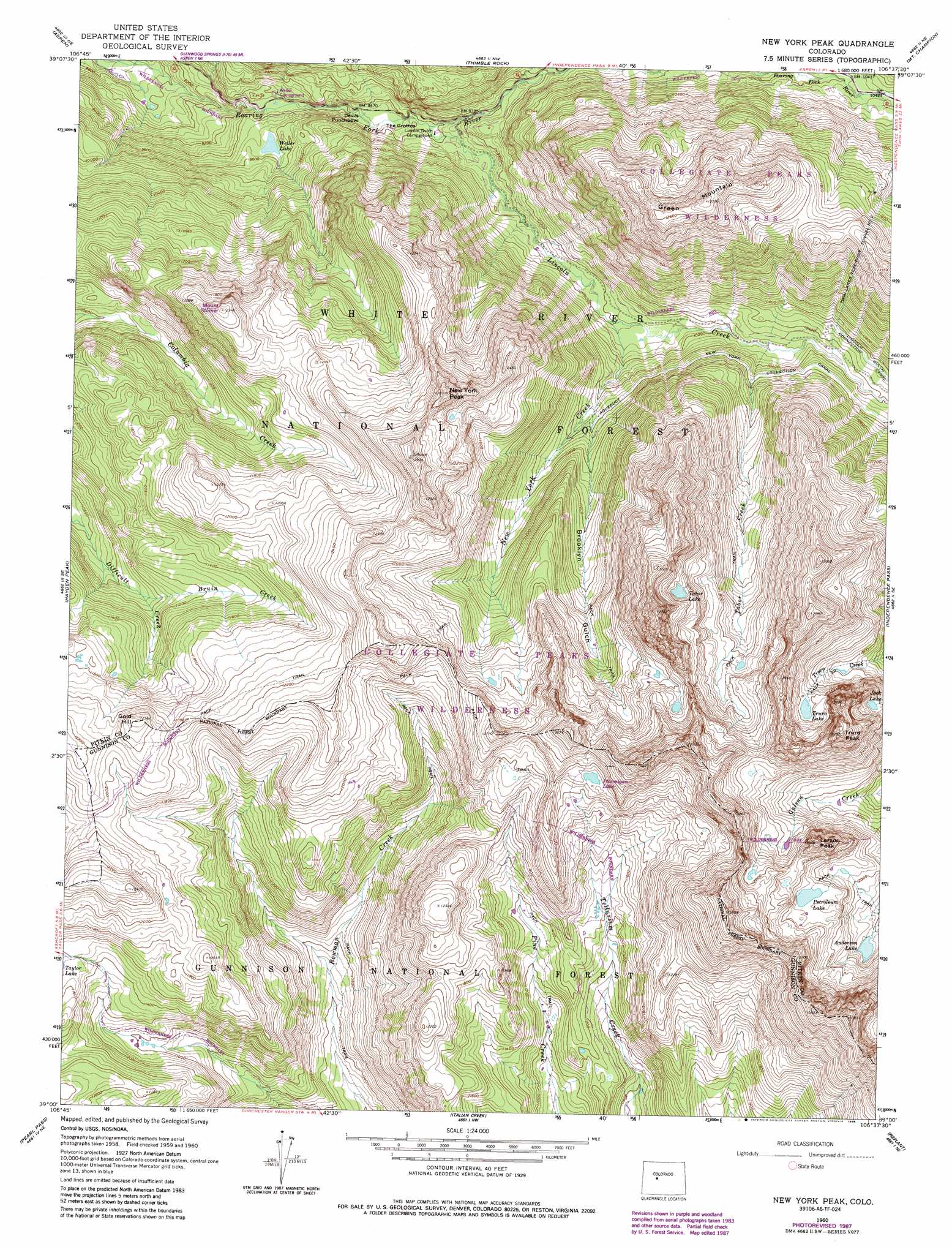
USGS Topo Quad 39106a6 - 1:24,000 scale
| Topo Map Name: | New York Peak |
| USGS Topo Quad ID: | 39106a6 |
| Print Size: | ca. 21 1/4" wide x 27" high |
| Southeast Coordinates: | 39° N latitude / 106.625° W longitude |
| Map Center Coordinates: | 39.0625° N latitude / 106.6875° W longitude |
| U.S. State: | CO |
| Filename: | o39106a6.jpg |
| Download Map JPG Image: | New York Peak topo map 1:24,000 scale |
| Map Type: | Topographic |
| Topo Series: | 7.5´ |
| Map Scale: | 1:24,000 |
| Source of Map Images: | United States Geological Survey (USGS) |
| Alternate Map Versions: |
New York Peak CO 1960, updated 1964 Download PDF Buy paper map New York Peak CO 1960, updated 1964 Download PDF Buy paper map New York Peak CO 1960, updated 1968 Download PDF Buy paper map New York Peak CO 1960, updated 1968 Download PDF Buy paper map New York Peak CO 1960, updated 1988 Download PDF Buy paper map New York Peak CO 2011 Download PDF Buy paper map New York Peak CO 2013 Download PDF Buy paper map New York Peak CO 2016 Download PDF Buy paper map |
| FStopo: | US Forest Service topo New York Peak is available: Download FStopo PDF Download FStopo TIF |
1:24,000 Topo Quads surrounding New York Peak
Woody Creek |
Ruedi |
Meredith |
Nast |
Homestake Reservoir |
Highland Peak |
Aspen |
Thimble Rock |
Mount Champion |
Mount Massive |
Maroon Bells |
Hayden Peak |
New York Peak |
Independence Pass |
Mount Elbert |
Gothic |
Pearl Pass |
Italian Creek |
Pieplant |
Winfield |
Crested Butte |
Cement Mountain |
Matchless Mountain |
Taylor Park Reservoir |
Tincup |
> Back to 39106a1 at 1:100,000 scale
> Back to 39106a1 at 1:250,000 scale
> Back to U.S. Topo Maps home
New York Peak topo map: Gazetteer
New York Peak: Basins
Devils Punchbowl elevation 2876m 9435′New York Peak: Canals
Lincoln Gulch Connection Canal elevation 3245m 10646′New York Collection Canal elevation 3232m 10603′
New York Peak: Lakes
Anderson Lake elevation 3605m 11827′Jack Lake elevation 3730m 12237′
Petroleum Lake elevation 3751m 12306′
Ptarmigan Lake elevation 3748m 12296′
Tabor Lake elevation 3753m 12312′
Tellurium Lake elevation 3751m 12306′
Truro Lake elevation 3713m 12181′
Weller Lake elevation 2909m 9543′
New York Peak: Mines
Gold Hill Tunnel Mine elevation 3574m 11725′Independence Number One Mine elevation 3478m 11410′
New York Peak: Streams
Bruin Creek elevation 3324m 10905′Lincoln Creek elevation 2921m 9583′
Lost Man Creek elevation 3198m 10492′
New York Creek elevation 3049m 10003′
Ptarmigan Creek elevation 3029m 9937′
Tabor Creek elevation 3239m 10626′
New York Peak: Summits
Gold Hill elevation 3767m 12358′Green Mountain elevation 3384m 11102′
Larson Peak elevation 3915m 12844′
Mount Shimer elevation 3761m 12339′
New York Peak elevation 3901m 12798′
Truro Peak elevation 4047m 13277′
New York Peak: Tunnels
Twin Lakes Reservoir Tunnel Number 2 elevation 3709m 12168′New York Peak: Valleys
Brooklyn Gulch elevation 3195m 10482′The Grottos elevation 2896m 9501′
New York Peak digital topo map on disk
Buy this New York Peak topo map showing relief, roads, GPS coordinates and other geographical features, as a high-resolution digital map file on DVD: