Mount Sherman Topo Map Colorado
To zoom in, hover over the map of Mount Sherman
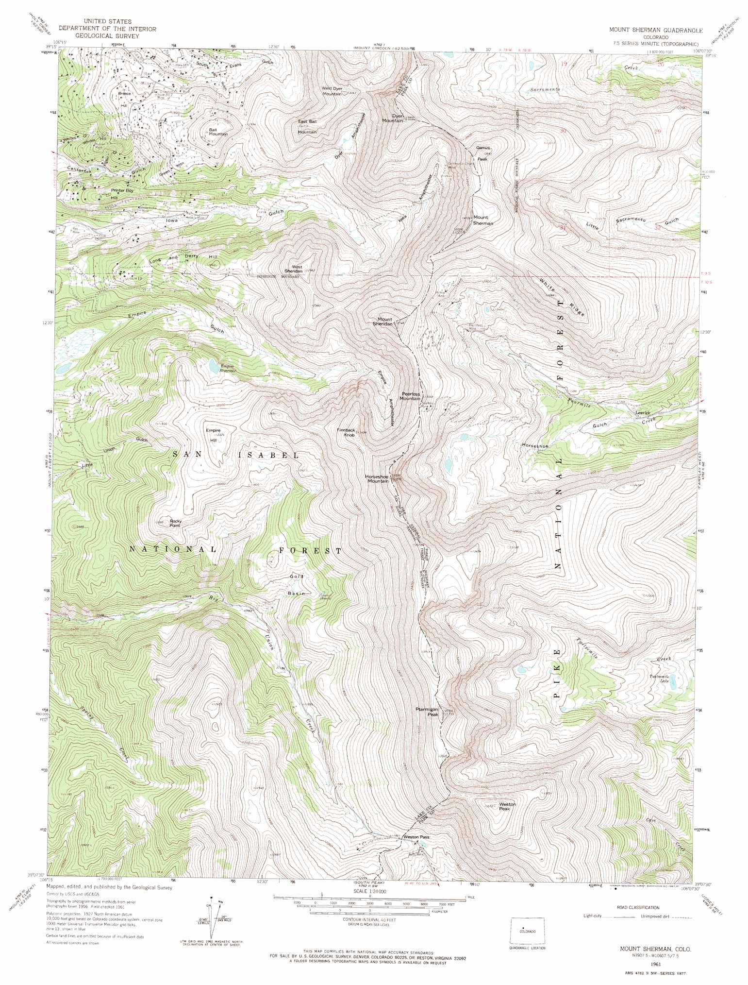
USGS Topo Quad 39106b2 - 1:24,000 scale
| Topo Map Name: | Mount Sherman |
| USGS Topo Quad ID: | 39106b2 |
| Print Size: | ca. 21 1/4" wide x 27" high |
| Southeast Coordinates: | 39.125° N latitude / 106.125° W longitude |
| Map Center Coordinates: | 39.1875° N latitude / 106.1875° W longitude |
| U.S. State: | CO |
| Filename: | o39106b2.jpg |
| Download Map JPG Image: | Mount Sherman topo map 1:24,000 scale |
| Map Type: | Topographic |
| Topo Series: | 7.5´ |
| Map Scale: | 1:24,000 |
| Source of Map Images: | United States Geological Survey (USGS) |
| Alternate Map Versions: |
Mount Sherman CO 1961, updated 1963 Download PDF Buy paper map Mount Sherman CO 1961, updated 1963 Download PDF Buy paper map Mount Sherman CO 1961, updated 1967 Download PDF Buy paper map Mount Sherman CO 1961, updated 1967 Download PDF Buy paper map Mount Sherman CO 1961, updated 1987 Download PDF Buy paper map Mount Sherman CO 1994, updated 1998 Download PDF Buy paper map Mount Sherman CO 2011 Download PDF Buy paper map Mount Sherman CO 2013 Download PDF Buy paper map Mount Sherman CO 2016 Download PDF Buy paper map |
| FStopo: | US Forest Service topo Mount Sherman is available: Download FStopo PDF Download FStopo TIF |
1:24,000 Topo Quads surrounding Mount Sherman
Mount Of The Holy Cross |
Pando |
Copper Mountain |
Breckenridge |
Boreas Pass |
Homestake Reservoir |
Leadville North |
Climax |
Alma |
Como |
Mount Massive |
Leadville South |
Mount Sherman |
Fairplay West |
Fairplay East |
Mount Elbert |
Granite |
South Peak |
Jones Hill |
Garo |
Winfield |
Mount Harvard |
Harvard Lakes |
Marmot Peak |
Antero Reservoir |
> Back to 39106a1 at 1:100,000 scale
> Back to 39106a1 at 1:250,000 scale
> Back to U.S. Topo Maps home
Mount Sherman topo map: Gazetteer
Mount Sherman: Airports
Saint Vincent General Hospital Heliport elevation 3420m 11220′Mount Sherman: Basins
Dyer Amphitheater elevation 3690m 12106′Empire Amphitheater elevation 3710m 12171′
Gold Basin elevation 3457m 11341′
Iowa Amphitheater elevation 3705m 12155′
Mount Sherman: Dams
Black Cloud Tailing Pond Dam elevation 3355m 11007′Mount Sherman: Flats
Idaho Park elevation 3490m 11450′Mount Sherman: Gaps
Weston Pass elevation 3636m 11929′Mount Sherman: Lakes
Leavick Tarn elevation 3752m 12309′Twelvemile Lake elevation 3386m 11108′
Mount Sherman: Mines
Agwalt Tunnel Mine elevation 3377m 11079′Alma Number One Mine elevation 3581m 11748′
Altoona Mine elevation 3302m 10833′
Antioch Quarry elevation 3542m 11620′
April Fool Number One Mine elevation 3487m 11440′
April Fool Number Three Mine elevation 3487m 11440′
Badger Boy Shaft elevation 3791m 12437′
Bald Mountain Shaft elevation 3646m 11961′
Ball Mountain Mine elevation 3580m 11745′
Ballard Mine elevation 3443m 11295′
Banker Mine elevation 3381m 11092′
Banner Mine elevation 3463m 11361′
Beck Shaft elevation 3414m 11200′
Belcher Shaft elevation 3520m 11548′
Big Chicago Mine elevation 3439m 11282′
Black Cloud Mine elevation 3359m 11020′
Black Prince Mine elevation 3484m 11430′
Blanche Mine elevation 3454m 11332′
Chippewa Mine elevation 3437m 11276′
Clear Grit Mine elevation 3355m 11007′
Colorado Princess Mine elevation 3590m 11778′
Comstock Copper Mine elevation 3528m 11574′
Continental Chief Mine elevation 3879m 12726′
Dauntless Mine elevation 3739m 12267′
Eclipse Mine elevation 3537m 11604′
Eliza Mine elevation 3483m 11427′
Elk and Grey Swan Group Mine elevation 3513m 11525′
Ella Beller Mine elevation 3345m 10974′
Estay Tunnel Mine elevation 3378m 11082′
Free American Number Two Mine elevation 3415m 11204′
Garbutt Mine elevation 3547m 11637′
Garibaldi Tunnel Mine elevation 3407m 11177′
Giant Mine elevation 3433m 11263′
Hard to Beat Mine elevation 3434m 11266′
Hellena Mine elevation 3344m 10971′
Highland Chief Mine elevation 3589m 11774′
Hilda Tunnel Mine elevation 4046m 13274′
Hilltop Mine elevation 3940m 12926′
Hopemore Mine elevation 3515m 11532′
Horseshoe Claims Mine elevation 3630m 11909′
Houston Tunnel Mine elevation 3509m 11512′
Howard Shaft elevation 3419m 11217′
Ibex Mines elevation 3502m 11489′
Irene Number 2 Mine elevation 3543m 11624′
Julia Fiske Mine elevation 3347m 10980′
Katy Mine elevation 3376m 11076′
Last Chance Mine elevation 3932m 12900′
Last Chance Mine elevation 4021m 13192′
Little Alice Tunnel Mine elevation 3428m 11246′
Little Vinnie Mine elevation 3498m 11476′
Long and Deery Mine elevation 3505m 11499′
Lyons Placer Mine elevation 3419m 11217′
Majestic Mine elevation 3496m 11469′
Mammoth Mine elevation 3653m 11984′
Maud Mine elevation 3981m 13061′
Miller Shaft elevation 3905m 12811′
Modest Barrel Mine elevation 3359m 11020′
Modoc Mine elevation 3469m 11381′
Negro Infant Mine elevation 3576m 11732′
Nevada Tunnel Mine elevation 3463m 11361′
New England Mine elevation 3407m 11177′
Ontario Shaft elevation 3542m 11620′
Peerless Mine elevation 3990m 13090′
Peerless Tunnel Mine elevation 3936m 12913′
Pilot Mine elevation 3307m 10849′
President Shaft elevation 3468m 11377′
Ready Cash Mine elevation 3473m 11394′
Reveille Mine elevation 3320m 10892′
Rex Mine elevation 3244m 10643′
Rob Roy Shaft elevation 3851m 12634′
Ruby Mine elevation 3586m 11765′
Saint Ann Mine elevation 3494m 11463′
Seneca Mine elevation 3470m 11384′
Sherman Tunnel Mine elevation 3873m 12706′
Steel Spring Mine elevation 3352m 10997′
Sunday Mine elevation 3640m 11942′
Triumph Mine elevation 3522m 11555′
Uintah Placer Mine elevation 3975m 13041′
Venier Mine elevation 3559m 11676′
Weston Pass Mine elevation 3635m 11925′
Whiteside Shaft elevation 3506m 11502′
Mount Sherman: Populated Places
Leavick (historical) elevation 3427m 11243′Mount Sherman: Ranges
Mosquito Range elevation 3803m 12477′Mount Sherman: Reservoirs
Black Cloud Tailings Pond elevation 3355m 11007′Empire Reservoir elevation 3561m 11683′
Mount Sherman: Ridges
White Ridge elevation 4174m 13694′Mount Sherman: Summits
Ball Mountain elevation 3748m 12296′Breece Hill elevation 3557m 11669′
Dyer Mountain elevation 4214m 13825′
East Ball Mountain elevation 3919m 12857′
Empire Hill elevation 3750m 12303′
Finnback Knob elevation 4085m 13402′
Gemini Peak elevation 4243m 13920′
Green Mountain elevation 3580m 11745′
Horseshoe Mountain elevation 4235m 13894′
Long and Derry Hill elevation 3668m 12034′
Mount Sheridan elevation 4189m 13743′
Mount Sherman elevation 4270m 14009′
Peerless Mountain elevation 4065m 13336′
Printer Boy Hill elevation 3476m 11404′
Ptarmigan Peak elevation 4182m 13720′
Rocky Point elevation 3681m 12076′
West Dyer Mountain elevation 3976m 13044′
West Sheridan elevation 3932m 12900′
Weston Peak elevation 4135m 13566′
Whites Hill elevation 3421m 11223′
Mount Sherman: Valleys
Alps Gulch elevation 3446m 11305′Horseshoe Gulch elevation 3429m 11250′
Pigtail Gulch elevation 3332m 10931′
Mount Sherman digital topo map on disk
Buy this Mount Sherman topo map showing relief, roads, GPS coordinates and other geographical features, as a high-resolution digital map file on DVD: