Highland Peak Topo Map Colorado
To zoom in, hover over the map of Highland Peak
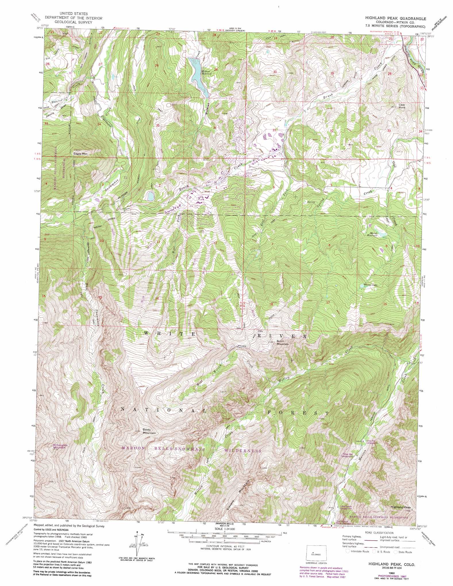
USGS Topo Quad 39106b8 - 1:24,000 scale
| Topo Map Name: | Highland Peak |
| USGS Topo Quad ID: | 39106b8 |
| Print Size: | ca. 21 1/4" wide x 27" high |
| Southeast Coordinates: | 39.125° N latitude / 106.875° W longitude |
| Map Center Coordinates: | 39.1875° N latitude / 106.9375° W longitude |
| U.S. State: | CO |
| Filename: | o39106b8.jpg |
| Download Map JPG Image: | Highland Peak topo map 1:24,000 scale |
| Map Type: | Topographic |
| Topo Series: | 7.5´ |
| Map Scale: | 1:24,000 |
| Source of Map Images: | United States Geological Survey (USGS) |
| Alternate Map Versions: |
Highland Peak CO 1960, updated 1964 Download PDF Buy paper map Highland Peak CO 1960, updated 1967 Download PDF Buy paper map Highland Peak CO 1960, updated 1967 Download PDF Buy paper map Highland Peak CO 1960, updated 1988 Download PDF Buy paper map Highland Peak CO 2011 Download PDF Buy paper map Highland Peak CO 2013 Download PDF Buy paper map Highland Peak CO 2016 Download PDF Buy paper map |
| FStopo: | US Forest Service topo Highland Peak is available: Download FStopo PDF Download FStopo TIF |
1:24,000 Topo Quads surrounding Highland Peak
Carbondale |
Leon |
Toner Reservoir |
Red Creek |
Crooked Creek Pass |
Mount Sopris |
Basalt |
Woody Creek |
Ruedi |
Meredith |
Redstone |
Capitol Peak |
Highland Peak |
Aspen |
Thimble Rock |
Marble |
Snowmass Mountain |
Maroon Bells |
Hayden Peak |
New York Peak |
Marcellina Mountain |
Oh-Be-Joyful |
Gothic |
Pearl Pass |
Italian Creek |
> Back to 39106a1 at 1:100,000 scale
> Back to 39106a1 at 1:250,000 scale
> Back to U.S. Topo Maps home
Highland Peak topo map: Gazetteer
Highland Peak: Canals
East Snowmass and Brush Creek Ditch elevation 2727m 8946′Elk Creek Ditch elevation 2657m 8717′
Elk Creek Ditch Number 2 elevation 2571m 8435′
Herrick Ditch elevation 2569m 8428′
Lemond Ditch elevation 2330m 7644′
McKenzie Wildcat Ditch elevation 2627m 8618′
Powell Mc Kenzie Ditch elevation 2471m 8106′
Wiese Upper Ditch elevation 2330m 7644′
Willow and Owl Ditch elevation 3320m 10892′
Highland Peak: Dams
Wildcat Dam elevation 2496m 8188′Highland Peak: Lakes
Whites Lake elevation 2824m 9265′Highland Peak: Mines
Mayflower Mine elevation 2657m 8717′Millinee Mine elevation 3165m 10383′
Munn Tunnel Mine elevation 2553m 8375′
Highland Peak: Populated Places
Snowmass Village elevation 2502m 8208′Highland Peak: Reservoirs
Marolt Reservoir elevation 2609m 8559′Wildcat Reservoir elevation 2495m 8185′
Highland Peak: Streams
East Fork Brush Creek elevation 2414m 7919′East Snowmass Creek elevation 2530m 8300′
Hunter Creek elevation 2425m 7956′
Spring Creek elevation 2444m 8018′
West Fork Brush Creek elevation 2567m 8421′
West Willow Creek elevation 2889m 9478′
Willow Creek elevation 2500m 8202′
Highland Peak: Summits
Baldy Mountain elevation 3997m 13113′Burnt Mountain elevation 3391m 11125′
Cozy Point elevation 2589m 8494′
Eagle Mountain elevation 3025m 9924′
Highland Peak elevation 3757m 12326′
Willoughby Mountain elevation 4004m 13136′
Highland Peak: Valleys
Johnny Draw elevation 2585m 8480′Highland Peak digital topo map on disk
Buy this Highland Peak topo map showing relief, roads, GPS coordinates and other geographical features, as a high-resolution digital map file on DVD: