Climax Topo Map Colorado
To zoom in, hover over the map of Climax
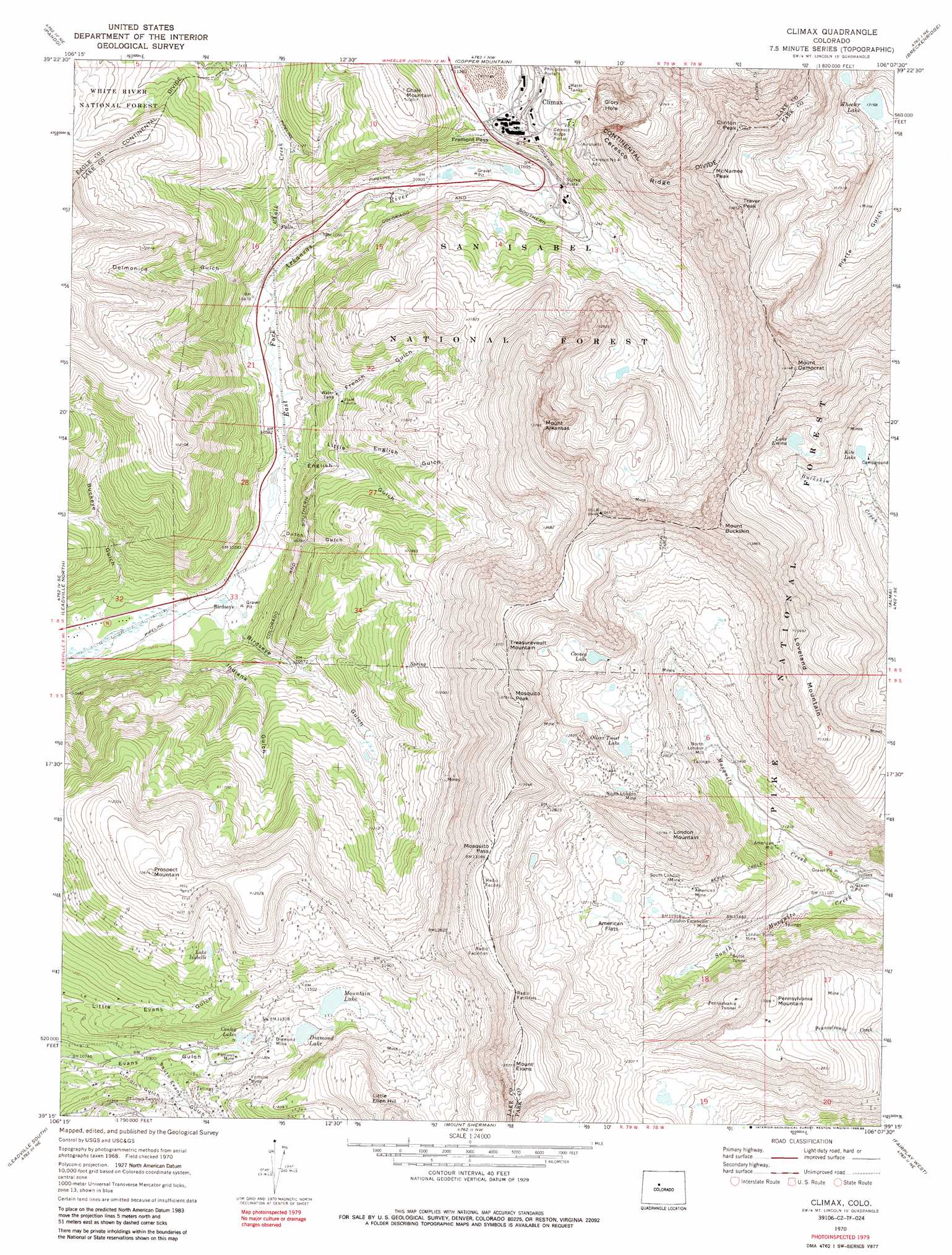
USGS Topo Quad 39106c2 - 1:24,000 scale
| Topo Map Name: | Climax |
| USGS Topo Quad ID: | 39106c2 |
| Print Size: | ca. 21 1/4" wide x 27" high |
| Southeast Coordinates: | 39.25° N latitude / 106.125° W longitude |
| Map Center Coordinates: | 39.3125° N latitude / 106.1875° W longitude |
| U.S. State: | CO |
| Filename: | o39106c2.jpg |
| Download Map JPG Image: | Climax topo map 1:24,000 scale |
| Map Type: | Topographic |
| Topo Series: | 7.5´ |
| Map Scale: | 1:24,000 |
| Source of Map Images: | United States Geological Survey (USGS) |
| Alternate Map Versions: |
Climax CO 1970, updated 1973 Download PDF Buy paper map Climax CO 1970, updated 1973 Download PDF Buy paper map Climax CO 1970, updated 1986 Download PDF Buy paper map Climax CO 1970, updated 1986 Download PDF Buy paper map Climax CO 1970, updated 1988 Download PDF Buy paper map Climax CO 1994, updated 1998 Download PDF Buy paper map Climax CO 2011 Download PDF Buy paper map Climax CO 2013 Download PDF Buy paper map Climax CO 2016 Download PDF Buy paper map |
| FStopo: | US Forest Service topo Climax is available: Download FStopo PDF Download FStopo TIF |
1:24,000 Topo Quads surrounding Climax
Minturn |
Red Cliff |
Vail Pass |
Frisco |
Keystone |
Mount Of The Holy Cross |
Pando |
Copper Mountain |
Breckenridge |
Boreas Pass |
Homestake Reservoir |
Leadville North |
Climax |
Alma |
Como |
Mount Massive |
Leadville South |
Mount Sherman |
Fairplay West |
Fairplay East |
Mount Elbert |
Granite |
South Peak |
Jones Hill |
Garo |
> Back to 39106a1 at 1:100,000 scale
> Back to 39106a1 at 1:250,000 scale
> Back to U.S. Topo Maps home
Climax topo map: Gazetteer
Climax: Dams
Evans Gulch Number 2 Dam elevation 3460m 11351′Climax: Flats
American Flats elevation 3682m 12080′Climax: Gaps
Fremont Pass elevation 3443m 11295′Mosquito Pass elevation 4017m 13179′
Climax: Lakes
Cooney Lake elevation 3835m 12582′Kite Lake elevation 3666m 12027′
Lake Emma elevation 3849m 12627′
Lake Isabelle elevation 3568m 11706′
Wheeler Lake elevation 3711m 12175′
Climax: Mines
Aetna Mine elevation 3931m 12896′Allegheny Placer Mine elevation 3979m 13054′
American Mine elevation 3684m 12086′
Apex Mine elevation 3650m 11975′
Arkansas Pit elevation 3185m 10449′
B F D Mine elevation 3709m 12168′
Baltic Number One Mine elevation 3856m 12650′
Belle Placer Mine elevation 3635m 11925′
Black Cloud Group Mine elevation 3571m 11715′
Blanchard Mine elevation 3723m 12214′
Butte Tunnel elevation 3463m 11361′
Ceresco Number 4 Adit elevation 3617m 11866′
Chalk Mountain Quarry elevation 3605m 11827′
Champagne Mine elevation 3620m 11876′
Champaign and Coney Claims Mine elevation 3620m 11876′
Chautauquan Mine elevation 3403m 11164′
Cleveland Mine elevation 3415m 11204′
Climax Mine elevation 3559m 11676′
Climax Surface Mine elevation 3428m 11246′
Cloverleaf Mine elevation 3422m 11227′
Colorado Belle Placer elevation 3632m 11916′
Colorado Travel Tunnel Mine elevation 3962m 12998′
Cornish Wall Mine elevation 3815m 12516′
Dempsey Mine elevation 3543m 11624′
Diamond Mine elevation 3840m 12598′
Disberger Mine elevation 3962m 12998′
Doublin Tunnel Mine elevation 3556m 11666′
East London Mine elevation 3346m 10977′
Excelsior Mining Group Mine elevation 3635m 11925′
Famous Mine elevation 3401m 11158′
Fanny Number Four Mine elevation 3687m 12096′
Fanny Number One Mine elevation 3687m 12096′
Fanny Number Three Mine elevation 3687m 12096′
Fanny Number Two Mine elevation 3687m 12096′
Finnerty Mine elevation 3762m 12342′
Forest Rose Mine elevation 3378m 11082′
Fortune Mine elevation 3462m 11358′
Fraction Mine elevation 3659m 12004′
Glory Hole elevation 3426m 11240′
Golden Mine elevation 3822m 12539′
Greenfield Tunnel Mine elevation 3823m 12542′
Havighorst Mine elevation 3456m 11338′
Henry D Mine elevation 3776m 12388′
Howbert Mine elevation 3907m 12818′
Hugh Shaft elevation 3412m 11194′
Imperial Mine elevation 3811m 12503′
Joe Dandy Mine elevation 3498m 11476′
John Reed Mine elevation 3465m 11368′
John Reed Mine elevation 3712m 12178′
Jones R L Mining Claims elevation 3468m 11377′
Kentucky Belle Mine elevation 3799m 12463′
Key Mine elevation 3482m 11423′
Kidnap Shaft elevation 3795m 12450′
Kivari Number One Mine elevation 3743m 12280′
Kleff Shaft elevation 3364m 11036′
Little Bob Shaft elevation 3392m 11128′
Little Corinne Mine elevation 3896m 12782′
Little Ellen Mine elevation 3469m 11381′
Little Galesburg Mine elevation 3368m 11049′
Little J Mine elevation 3650m 11975′
Little Newton Mine elevation 3776m 12388′
Little Prince Mine elevation 3417m 11210′
London Butte Mine elevation 3429m 11250′
London Extension Mine elevation 3554m 11660′
Lone Jack Mine elevation 4185m 13730′
Lower Baltic Mine elevation 3856m 12650′
Lower Clipper Mine elevation 3553m 11656′
Luema Mine elevation 3366m 11043′
Lulu Mine elevation 3638m 11935′
Maumee Mine elevation 3555m 11663′
McDonald Mine elevation 3650m 11975′
Middle Clipper Mine elevation 3553m 11656′
Miller Mine elevation 3640m 11942′
Monarch Mine elevation 3424m 11233′
Mosher Shaft elevation 3650m 11975′
Mosquito Mining District Mine elevation 3815m 12516′
Mosquito Range Mine elevation 3657m 11998′
Mountain Chief Number Three Mine elevation 3707m 12162′
New York Mine elevation 3807m 12490′
New York Mine elevation 3771m 12372′
North London Mine elevation 3765m 12352′
Ollie Reed Mine elevation 3404m 11167′
Olver Twist Tunnel Mine elevation 3736m 12257′
Ophir Mine elevation 3484m 11430′
Oro Grande Group Mine elevation 3405m 11171′
Ovens Number One Mine elevation 3819m 12529′
Ovens Number Two Mine elevation 3819m 12529′
Page Tunnel Mine elevation 3368m 11049′
Parnell Mine elevation 3650m 11975′
Pawnee Mine elevation 3525m 11564′
Penn Number One Mine elevation 3451m 11322′
Pennsylvania Tunnel elevation 3754m 12316′
Prince Frederick Mine elevation 3891m 12765′
Resurrection Mine elevation 3488m 11443′
Riche Shaft elevation 3803m 12477′
S S Tunnel Mine elevation 3456m 11338′
Saint Louis Mine elevation 3465m 11368′
Saint Louis Tunnel elevation 3410m 11187′
Silver Spoon Mine elevation 3403m 11164′
Small Hopes Mine elevation 3362m 11030′
South End Shaft elevation 3598m 11804′
South London Mine elevation 3685m 12089′
Souvenir Mine elevation 3884m 12742′
Tenderfoot Shaft elevation 3425m 11236′
Upper Baltic Shaft elevation 3881m 12732′
Upper Clipper Mine elevation 3553m 11656′
Upper Ovens Tunnel Mine elevation 3819m 12529′
Venture Mine elevation 3768m 12362′
Venus Mine elevation 3827m 12555′
Vienna Mine elevation 3801m 12470′
Virginius Mine elevation 3391m 11125′
Wheeler Group Mine elevation 3777m 12391′
Winnie Mine elevation 3403m 11164′
Wyandotte Mine elevation 3833m 12575′
Yale Tunnel Mine elevation 3408m 11181′
Zephyr Mine elevation 3764m 12349′
Climax: Populated Places
Birdseye elevation 3114m 10216′Climax (historical) elevation 3462m 11358′
Climax: Reservoirs
Conley Lakes elevation 3399m 11151′Diamond Lake elevation 3468m 11377′
Evans Gulch Number 2 Reservoir elevation 3460m 11351′
Mountain Lake elevation 3490m 11450′
Oliver Twist Lake elevation 3713m 12181′
Climax: Ridges
Ceresco Ridge elevation 3844m 12611′Climax: Streams
Chalk Creek elevation 3194m 10479′Climax: Summits
Chalk Mountain elevation 3599m 11807′Clinton Peak elevation 4210m 13812′
Little Ellen Hill elevation 3761m 12339′
London Mountain elevation 4018m 13182′
McNamee Peak elevation 4198m 13772′
McNamee Peak elevation 4197m 13769′
Mosquito Peak elevation 4174m 13694′
Mount Arkansas elevation 4201m 13782′
Mount Buckskin elevation 4205m 13795′
Mount Democrat elevation 4310m 14140′
Mount Evans elevation 4135m 13566′
Mount Tweto elevation 4151m 13618′
Pennsylvania Mountain elevation 3969m 13021′
Prospect Mountain elevation 3844m 12611′
Traver Peak elevation 4223m 13854′
Treasurevault Mountain elevation 4173m 13690′
Climax: Tunnels
Ceresco Ridge Portal elevation 3500m 11482′Phillipson Portal elevation 3500m 11482′
Storke Portal elevation 3417m 11210′
Climax: Valleys
Birdseye Gulch elevation 3136m 10288′Buckeye Gulch elevation 3097m 10160′
Delmonica Gulch elevation 3210m 10531′
Dutch Gulch elevation 3162m 10374′
English Gulch elevation 3183m 10442′
French Gulch elevation 3172m 10406′
Indiana Gulch elevation 3110m 10203′
Lincoln Gulch elevation 3316m 10879′
Little English Gulch elevation 3221m 10567′
South Evans Gulch elevation 3328m 10918′
Climax digital topo map on disk
Buy this Climax topo map showing relief, roads, GPS coordinates and other geographical features, as a high-resolution digital map file on DVD: