Meredith Topo Map Colorado
To zoom in, hover over the map of Meredith
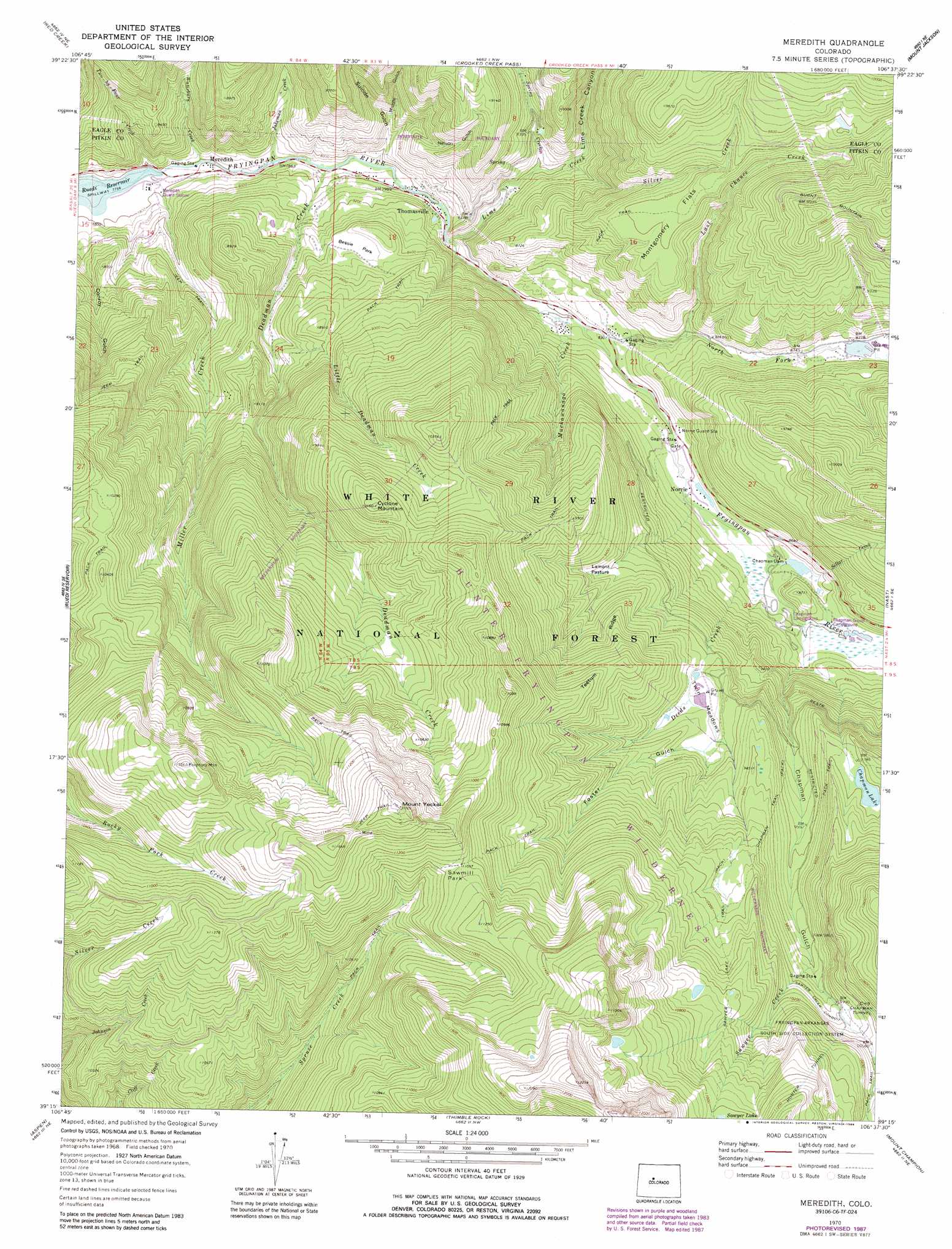
USGS Topo Quad 39106c6 - 1:24,000 scale
| Topo Map Name: | Meredith |
| USGS Topo Quad ID: | 39106c6 |
| Print Size: | ca. 21 1/4" wide x 27" high |
| Southeast Coordinates: | 39.25° N latitude / 106.625° W longitude |
| Map Center Coordinates: | 39.3125° N latitude / 106.6875° W longitude |
| U.S. State: | CO |
| Filename: | o39106c6.jpg |
| Download Map JPG Image: | Meredith topo map 1:24,000 scale |
| Map Type: | Topographic |
| Topo Series: | 7.5´ |
| Map Scale: | 1:24,000 |
| Source of Map Images: | United States Geological Survey (USGS) |
| Alternate Map Versions: |
Meredith CO 1970, updated 1973 Download PDF Buy paper map Meredith CO 1970, updated 1973 Download PDF Buy paper map Meredith CO 1970, updated 1977 Download PDF Buy paper map Meredith CO 1970, updated 1988 Download PDF Buy paper map Meredith CO 2011 Download PDF Buy paper map Meredith CO 2013 Download PDF Buy paper map Meredith CO 2016 Download PDF Buy paper map |
| FStopo: | US Forest Service topo Meredith is available: Download FStopo PDF Download FStopo TIF |
1:24,000 Topo Quads surrounding Meredith
Suicide Mountain |
The Seven Hermits |
Fulford |
Grouse Mountain |
Minturn |
Toner Reservoir |
Red Creek |
Crooked Creek Pass |
Mount Jackson |
Mount Of The Holy Cross |
Woody Creek |
Ruedi |
Meredith |
Nast |
Homestake Reservoir |
Highland Peak |
Aspen |
Thimble Rock |
Mount Champion |
Mount Massive |
Maroon Bells |
Hayden Peak |
New York Peak |
Independence Pass |
Mount Elbert |
> Back to 39106a1 at 1:100,000 scale
> Back to 39106a1 at 1:250,000 scale
> Back to U.S. Topo Maps home
Meredith topo map: Gazetteer
Meredith: Canals
Sawyer Creek Conduit elevation 3061m 10042′Meredith: Dams
Chapman Dam elevation 2605m 8546′Himmelland Dam elevation 2678m 8786′
Meredith: Flats
Bessie Park elevation 2569m 8428′Lamont Pasture elevation 2824m 9265′
Montgomery Flats elevation 2816m 9238′
Sawmill Park elevation 3362m 11030′
Twin Meadows elevation 2885m 9465′
Meredith: Lakes
Chapman Lake elevation 2983m 9786′Meredith: Mines
Country Boy Mine elevation 3115m 10219′Fryingpan Group Mine elevation 3421m 11223′
Meredith Mine elevation 2436m 7992′
Wellington Mine elevation 3100m 10170′
Meredith: Populated Places
Biglow elevation 2541m 8336′Meredith elevation 2369m 7772′
Norrie elevation 2579m 8461′
Thomasville elevation 2444m 8018′
Meredith: Post Offices
Meredith Post Office (historical) elevation 2369m 7772′Meredith: Reservoirs
Chapman Reservoir elevation 2605m 8546′Himmelland Reservoir elevation 2678m 8786′
Meredith: Ridges
Teetum Ridge elevation 3022m 9914′Meredith: Streams
Deadman Creek elevation 2409m 7903′Deeds Creek elevation 2580m 8464′
Jakeman Creek elevation 2392m 7847′
Last Chance Creek elevation 2590m 8497′
Lime Creek elevation 2451m 8041′
Little Deadman Creek elevation 2578m 8458′
Miller Creek elevation 2370m 7775′
Muckawanago Creek elevation 2493m 8179′
North Fork Fryingpan River elevation 2509m 8231′
Sawyer Creek elevation 2988m 9803′
Sellar Creek elevation 2595m 8513′
Silver Creek elevation 2506m 8221′
Spring Creek elevation 2490m 8169′
Two by Four Creek elevation 2381m 7811′
Waterbury Creek elevation 2369m 7772′
Meredith: Summits
Crowley Point elevation 2761m 9058′Cyclone Mountain elevation 3187m 10456′
Mount Yeckel elevation 3583m 11755′
Riley Mountain elevation 3150m 10334′
Meredith: Trails
Chapman Trail elevation 3003m 9852′Sawyer Lake Trail elevation 3148m 10328′
Meredith: Tunnels
Hunter Tunnel elevation 3382m 11095′Meredith: Valleys
Chapman Gulch elevation 3022m 9914′Conroy Gulch elevation 2380m 7808′
Foster Gulch elevation 2901m 9517′
Lime Creek Canyon elevation 2464m 8083′
Middle Gulch elevation 2486m 8156′
Nelson Gulch elevation 2462m 8077′
Suicide Gulch elevation 2427m 7962′
Meredith digital topo map on disk
Buy this Meredith topo map showing relief, roads, GPS coordinates and other geographical features, as a high-resolution digital map file on DVD: