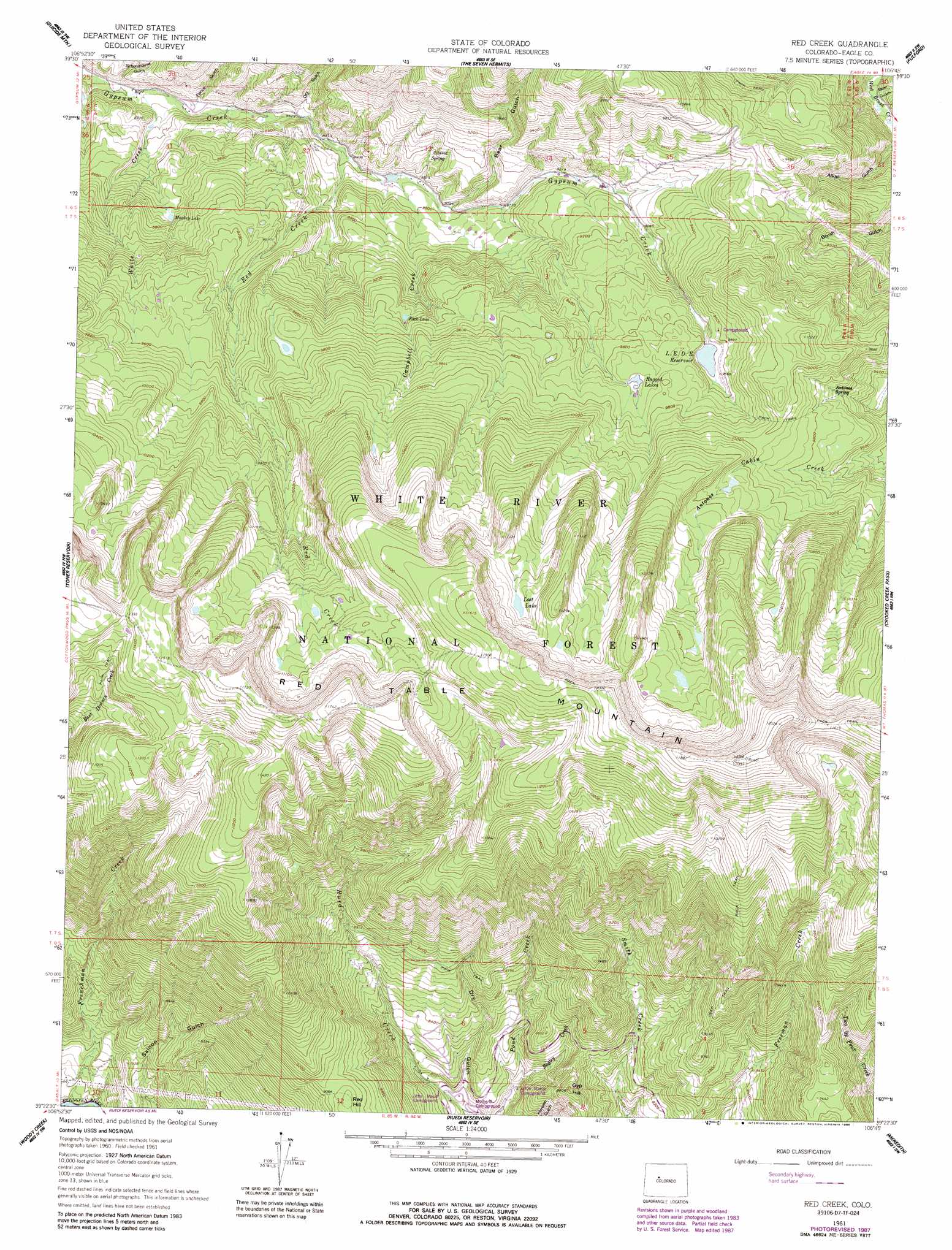
Red Creek Topo Map Colorado
To zoom in, hover over the map of Red Creek
USGS Topo Quad 39106d7 - 1:24,000 scale
| Topo Map Name: | Red Creek |
| USGS Topo Quad ID: | 39106d7 |
| Print Size: | ca. 21 1/4" wide x 27" high |
| Southeast Coordinates: | 39.375° N latitude / 106.75° W longitude |
| Map Center Coordinates: | 39.4375° N latitude / 106.8125° W longitude |
| U.S. State: | CO |
| Filename: | o39106d7.jpg |
| Download Map JPG Image: | Red Creek topo map 1:24,000 scale |
| Map Type: | Topographic |
| Topo Series: | 7.5´ |
| Map Scale: | 1:24,000 |
| Source of Map Images: | United States Geological Survey (USGS) |
| Alternate Map Versions: |
Red Creek CO 1961, updated 1963 Download PDF Buy paper map Red Creek CO 1961, updated 1963 Download PDF Buy paper map Red Creek CO 1961, updated 1968 Download PDF Buy paper map Red Creek CO 1961, updated 1988 Download PDF Buy paper map Red Creek CO 1961, updated 1988 Download PDF Buy paper map Red Creek CO 2011 Download PDF Buy paper map Red Creek CO 2013 Download PDF Buy paper map Red Creek CO 2016 Download PDF Buy paper map |
| FStopo: | US Forest Service topo Red Creek is available: Download FStopo PDF Download FStopo TIF |
1:24,000 Topo Quads surrounding Red Creek
Dotsero |
Gypsum |
Eagle |
Wolcott |
Edwards |
Cottonwood Pass |
Suicide Mountain |
The Seven Hermits |
Fulford |
Grouse Mountain |
Leon |
Toner Reservoir |
Red Creek |
Crooked Creek Pass |
Mount Jackson |
Basalt |
Woody Creek |
Ruedi |
Meredith |
Nast |
Capitol Peak |
Highland Peak |
Aspen |
Thimble Rock |
Mount Champion |
> Back to 39106a1 at 1:100,000 scale
> Back to 39106a1 at 1:250,000 scale
> Back to U.S. Topo Maps home
Red Creek topo map: Gazetteer
Red Creek: Dams
LEDE Dam elevation 2908m 9540′Red Creek: Forests
White River National Forest elevation 3513m 11525′Red Creek: Lakes
Lost Lake elevation 3312m 10866′Muckey Lake elevation 2632m 8635′
Ragged Lakes elevation 2934m 9625′
Rock Lake elevation 2852m 9356′
Red Creek: Reservoirs
LEDE Reservoir elevation 2908m 9540′Red Creek: Springs
Alldred Spring elevation 2688m 8818′Antones Spring elevation 2943m 9655′
Red Creek: Streams
Bagley Creek elevation 2418m 7933′Campbell Creek elevation 2587m 8487′
Frenchman Creek elevation 2214m 7263′
Hells Hole elevation 2808m 9212′
Red Creek elevation 2549m 8362′
White Creek elevation 2447m 8028′
Red Creek: Summits
Gyp Hill elevation 2685m 8809′Red Hill elevation 2784m 9133′
Red Table Mountain elevation 3665m 12024′
Red Creek: Valleys
Alkali Gulch elevation 2510m 8234′Bear Gulch elevation 2463m 8080′
Bear Gulch elevation 2618m 8589′
Dry Gulch elevation 2400m 7874′
Dry Gulch elevation 2546m 8353′
Fence Gulch elevation 2485m 8152′
Schoolhouse Gulch elevation 2446m 8024′
Red Creek digital topo map on disk
Buy this Red Creek topo map showing relief, roads, GPS coordinates and other geographical features, as a high-resolution digital map file on DVD: