The Seven Hermits Topo Map Colorado
To zoom in, hover over the map of The Seven Hermits
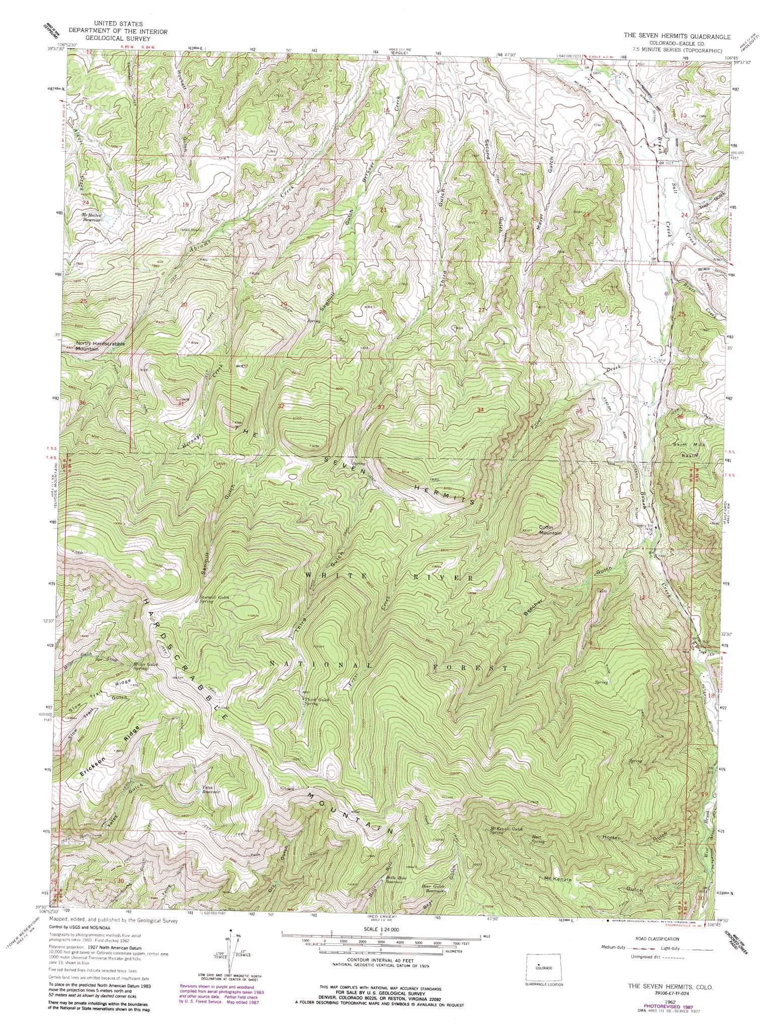
USGS Topo Quad 39106e7 - 1:24,000 scale
| Topo Map Name: | The Seven Hermits |
| USGS Topo Quad ID: | 39106e7 |
| Print Size: | ca. 21 1/4" wide x 27" high |
| Southeast Coordinates: | 39.5° N latitude / 106.75° W longitude |
| Map Center Coordinates: | 39.5625° N latitude / 106.8125° W longitude |
| U.S. State: | CO |
| Filename: | o39106e7.jpg |
| Download Map JPG Image: | The Seven Hermits topo map 1:24,000 scale |
| Map Type: | Topographic |
| Topo Series: | 7.5´ |
| Map Scale: | 1:24,000 |
| Source of Map Images: | United States Geological Survey (USGS) |
| Alternate Map Versions: |
The Seven Hermits CO 1962, updated 1964 Download PDF Buy paper map The Seven Hermits CO 1962, updated 1969 Download PDF Buy paper map The Seven Hermits CO 1962, updated 1982 Download PDF Buy paper map The Seven Hermits CO 1962, updated 1988 Download PDF Buy paper map The Seven Hermits CO 2011 Download PDF Buy paper map The Seven Hermits CO 2013 Download PDF Buy paper map The Seven Hermits CO 2016 Download PDF Buy paper map |
| FStopo: | US Forest Service topo The Seven Hermits is available: Download FStopo PDF Download FStopo TIF |
1:24,000 Topo Quads surrounding The Seven Hermits
Sugarloaf Mountain |
Burns South |
Castle Peak |
State Bridge |
Lava Creek |
Dotsero |
Gypsum |
Eagle |
Wolcott |
Edwards |
Cottonwood Pass |
Suicide Mountain |
The Seven Hermits |
Fulford |
Grouse Mountain |
Leon |
Toner Reservoir |
Red Creek |
Crooked Creek Pass |
Mount Jackson |
Basalt |
Woody Creek |
Ruedi |
Meredith |
Nast |
> Back to 39106e1 at 1:100,000 scale
> Back to 39106a1 at 1:250,000 scale
> Back to U.S. Topo Maps home
The Seven Hermits topo map: Gazetteer
The Seven Hermits: Basins
Skim Milk Basin elevation 2355m 7726′The Seven Hermits: Canals
Hollingsworth and Potter Ditch elevation 2137m 7011′McKenzie Ditch elevation 2122m 6961′
Peterson Ditch elevation 2370m 7775′
Peterson Ditch Number 1 elevation 2432m 7979′
Staton and Cissna Ditch elevation 2284m 7493′
The Seven Hermits: Mines
Ground Hog Mine elevation 2262m 7421′Horse Mountain Uranium Mines elevation 2296m 7532′
The Seven Hermits: Ranges
The Seven Hermits elevation 2589m 8494′The Seven Hermits: Reservoirs
Bear Gulch Reservoir elevation 3052m 10013′Hells Hole Reservoir elevation 3027m 9931′
McHatten Reservoir elevation 2277m 7470′
Yates Reservoir elevation 2944m 9658′
The Seven Hermits: Ridges
Erickson Ridge elevation 3042m 9980′Slow Trail Ridge elevation 2941m 9648′
The Seven Hermits: Springs
Hart Spring elevation 2886m 9468′McKenzie Gulch Spring elevation 2990m 9809′
Miller Gulch Spring elevation 2918m 9573′
Sawmill Gulch Spring elevation 3048m 10000′
Third Gulch Spring elevation 3061m 10042′
The Seven Hermits: Streams
Bruce Creek elevation 2168m 7112′East Brush Creek elevation 2312m 7585′
Frost Creek elevation 2197m 7208′
West Brush Creek elevation 2312m 7585′
The Seven Hermits: Summits
Coffin Mountain elevation 2834m 9297′Hardscrabble Mountain elevation 3296m 10813′
The Seven Hermits: Valleys
Beecher Gulch elevation 2280m 7480′Horton Gulch elevation 2442m 8011′
McKenzie Gulch elevation 2454m 8051′
Peterson Draw elevation 2452m 8044′
Sawmill Gulch elevation 2213m 7260′
Second Gulch elevation 2114m 6935′
Trail Gulch elevation 2162m 7093′
The Seven Hermits digital topo map on disk
Buy this The Seven Hermits topo map showing relief, roads, GPS coordinates and other geographical features, as a high-resolution digital map file on DVD: