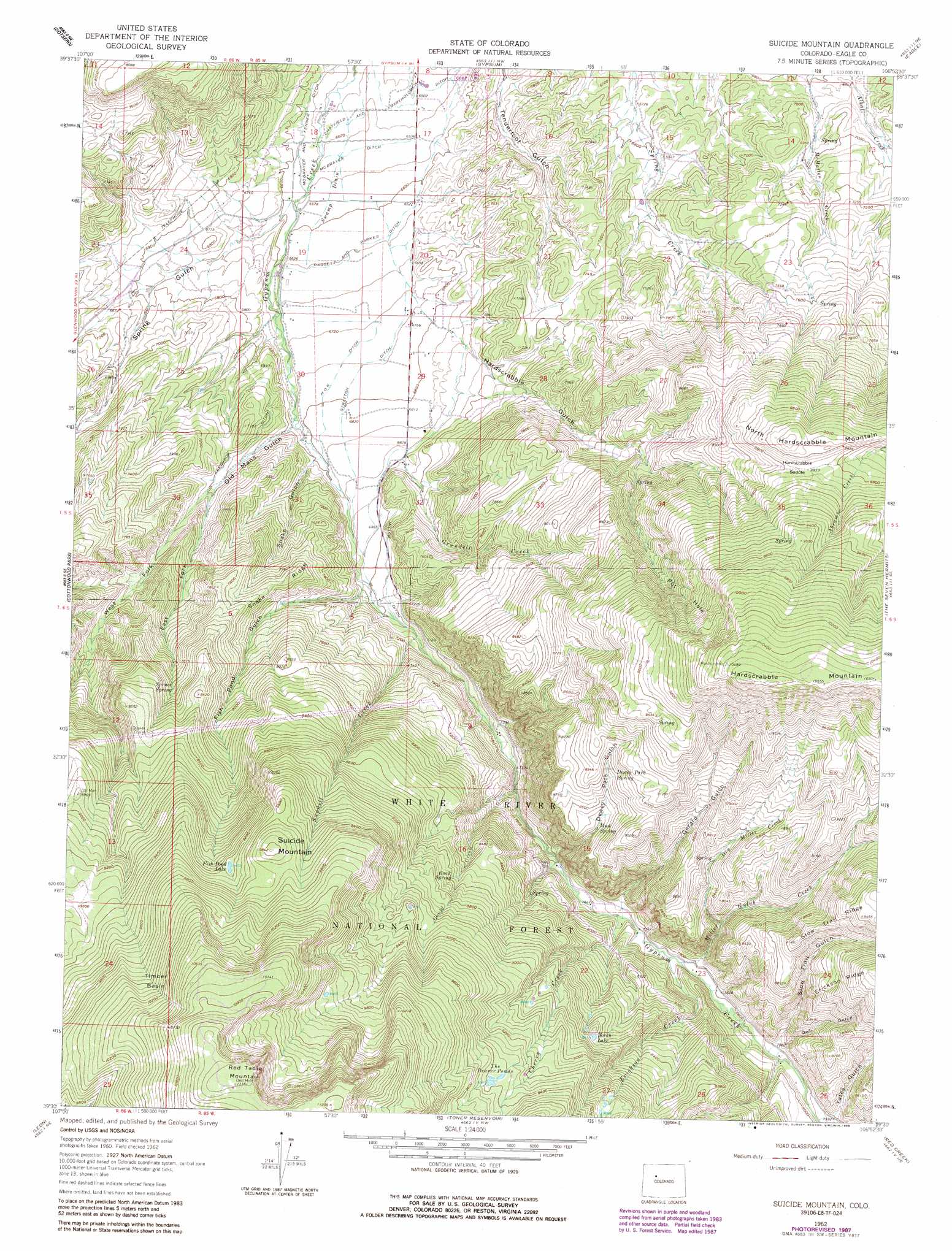
Suicide Mountain Topo Map Colorado
To zoom in, hover over the map of Suicide Mountain
USGS Topo Quad 39106e8 - 1:24,000 scale
| Topo Map Name: | Suicide Mountain |
| USGS Topo Quad ID: | 39106e8 |
| Print Size: | ca. 21 1/4" wide x 27" high |
| Southeast Coordinates: | 39.5° N latitude / 106.875° W longitude |
| Map Center Coordinates: | 39.5625° N latitude / 106.9375° W longitude |
| U.S. State: | CO |
| Filename: | o39106e8.jpg |
| Download Map JPG Image: | Suicide Mountain topo map 1:24,000 scale |
| Map Type: | Topographic |
| Topo Series: | 7.5´ |
| Map Scale: | 1:24,000 |
| Source of Map Images: | United States Geological Survey (USGS) |
| Alternate Map Versions: |
Suicide Mountain CO 1962, updated 1964 Download PDF Buy paper map Suicide Mountain CO 1962, updated 1969 Download PDF Buy paper map Suicide Mountain CO 1962, updated 1988 Download PDF Buy paper map Suicide Mountain CO 2011 Download PDF Buy paper map Suicide Mountain CO 2013 Download PDF Buy paper map Suicide Mountain CO 2016 Download PDF Buy paper map |
| FStopo: | US Forest Service topo Suicide Mountain is available: Download FStopo PDF Download FStopo TIF |
1:24,000 Topo Quads surrounding Suicide Mountain
Sweetwater Lake |
Sugarloaf Mountain |
Burns South |
Castle Peak |
State Bridge |
Broken Rib Creek |
Dotsero |
Gypsum |
Eagle |
Wolcott |
Shoshone |
Cottonwood Pass |
Suicide Mountain |
The Seven Hermits |
Fulford |
Carbondale |
Leon |
Toner Reservoir |
Red Creek |
Crooked Creek Pass |
Mount Sopris |
Basalt |
Woody Creek |
Ruedi |
Meredith |
> Back to 39106e1 at 1:100,000 scale
> Back to 39106a1 at 1:250,000 scale
> Back to U.S. Topo Maps home
Suicide Mountain topo map: Gazetteer
Suicide Mountain: Airports
Gypsum Creek Ranch Airport elevation 2056m 6745′Suicide Mountain: Basins
Pot Hole elevation 2762m 9061′Timber Basin elevation 3065m 10055′
Suicide Mountain: Canals
Daggett and Parker Ditch elevation 2025m 6643′Ferguson Ditch elevation 2129m 6984′
Ho O R Ditch elevation 2071m 6794′
McBrayer and Fenner Ditch elevation 2000m 6561′
McBrayer Ditch elevation 1993m 6538′
Miller Ditch elevation 2146m 7040′
Stratton Ditch elevation 2071m 6794′
Swamp Drain elevation 2001m 6564′
Suicide Mountain: Flats
Dewey Park elevation 2356m 7729′Suicide Mountain: Gaps
Hardscrabble Saddle elevation 2754m 9035′Suicide Mountain: Lakes
Borah Lake elevation 2630m 8628′Fish Pond Lake elevation 2875m 9432′
The Beaver Ponds elevation 2864m 9396′
Suicide Mountain: Ridges
Snake Ridge elevation 2344m 7690′Suicide Mountain: Springs
Dewey Park Spring elevation 2665m 8743′Mud Spring elevation 2568m 8425′
Rock Spring elevation 2620m 8595′
Spruce Spring elevation 2450m 8038′
Suicide Mountain: Streams
Cherry Creek elevation 2344m 7690′Dry Miller Creek elevation 2455m 8054′
Erickson Creek elevation 2364m 7755′
Gould Creek elevation 2257m 7404′
Grundell Creek elevation 2099m 6886′
Miller Gulch Creek elevation 2366m 7762′
Sundell Creek elevation 2163m 7096′
Suicide Mountain: Summits
North Hardscrabble Mountain elevation 2785m 9137′Suicide Mountain elevation 3001m 9845′
Suicide Mountain: Valleys
Dewey Park Gulch elevation 2344m 7690′East Fork Old Mans Gulch elevation 2131m 6991′
Fish Pond Canyon elevation 2141m 7024′
Fish Pond Gulch elevation 2139m 7017′
Gerard Gulch elevation 2471m 8106′
Hardscrabble Gulch elevation 2049m 6722′
Old Mans Gulch elevation 2074m 6804′
Owl Gulch elevation 2411m 7910′
Slow Trail Gulch elevation 2405m 7890′
Snake Gulch elevation 2076m 6811′
West Fork Old Mans Gulch elevation 2131m 6991′
Yates Gulch elevation 2441m 8008′
Suicide Mountain digital topo map on disk
Buy this Suicide Mountain topo map showing relief, roads, GPS coordinates and other geographical features, as a high-resolution digital map file on DVD: