Ute Peak Topo Map Colorado
To zoom in, hover over the map of Ute Peak
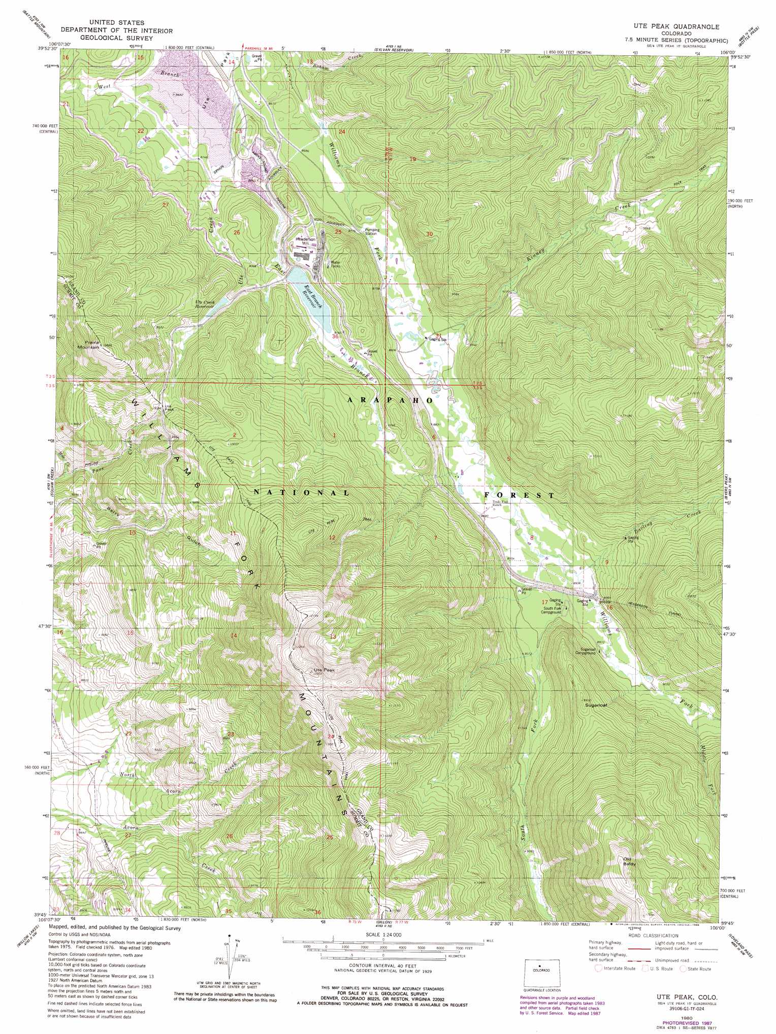
USGS Topo Quad 39106g1 - 1:24,000 scale
| Topo Map Name: | Ute Peak |
| USGS Topo Quad ID: | 39106g1 |
| Print Size: | ca. 21 1/4" wide x 27" high |
| Southeast Coordinates: | 39.75° N latitude / 106° W longitude |
| Map Center Coordinates: | 39.8125° N latitude / 106.0625° W longitude |
| U.S. State: | CO |
| Filename: | o39106g1.jpg |
| Download Map JPG Image: | Ute Peak topo map 1:24,000 scale |
| Map Type: | Topographic |
| Topo Series: | 7.5´ |
| Map Scale: | 1:24,000 |
| Source of Map Images: | United States Geological Survey (USGS) |
| Alternate Map Versions: |
Ute Peak CO 1980, updated 1980 Download PDF Buy paper map Ute Peak CO 1980, updated 1988 Download PDF Buy paper map Ute Peak CO 2011 Download PDF Buy paper map Ute Peak CO 2013 Download PDF Buy paper map Ute Peak CO 2016 Download PDF Buy paper map |
| FStopo: | US Forest Service topo Ute Peak is available: Download FStopo PDF Download FStopo TIF |
1:24,000 Topo Quads surrounding Ute Peak
Junction Butte |
Parshall |
Hot Sulpher Springs |
Granby |
Strawberry Lake |
King Creek |
Battle Mountain |
Sylvan Reservoir |
Bottle Pass |
Fraser |
Mount Powell |
Squaw Creek |
Ute Peak |
Byers Peak |
Berthoud Pass |
Vail East |
Willow Lakes |
Dillon |
Loveland Pass |
Grays Peak |
Red Cliff |
Vail Pass |
Frisco |
Keystone |
Montezuma |
> Back to 39106e1 at 1:100,000 scale
> Back to 39106a1 at 1:250,000 scale
> Back to U.S. Topo Maps home
Ute Peak topo map: Gazetteer
Ute Peak: Airports
Amax Mill Heliport elevation 2819m 9248′Ute Peak: Dams
East Branch Dam elevation 2755m 9038′Ute Creek Dam elevation 2878m 9442′
Ute Peak: Gaps
Ute Pass elevation 2917m 9570′Ute Peak: Populated Places
Leal elevation 2704m 8871′Ute Peak: Ranges
Williams Fork Mountains elevation 3256m 10682′Ute Peak: Reservoirs
East Branch Reservoir elevation 2755m 9038′Ute Creek Reservoir elevation 2813m 9229′
Ute Park Reservoir elevation 2878m 9442′
Ute Peak: Streams
Boham Creek elevation 2625m 8612′Darling Creek elevation 2722m 8930′
East Branch Ute Creek elevation 2650m 8694′
Hole Creek elevation 2611m 8566′
Kinney Creek elevation 2676m 8779′
Middle Fork Williams Fork elevation 2756m 9041′
South Fork Williams Fork elevation 2719m 8920′
West Branch Ute Creek elevation 2620m 8595′
Ute Peak: Summits
Old Baldy elevation 3609m 11840′Prairie Mountain elevation 3250m 10662′
Sugarloaf elevation 3031m 9944′
Ute Peak elevation 3741m 12273′
Ute Peak: Trails
Keyser Divide Trail elevation 3222m 10570′Ute Pass Trail elevation 2936m 9632′
Ute Peak Trail elevation 3320m 10892′
Ute Peak: Tunnels
Henderson Tunnel elevation 3068m 10065′Ute Peak: Valleys
Berry Gulch elevation 2633m 8638′Ute Peak digital topo map on disk
Buy this Ute Peak topo map showing relief, roads, GPS coordinates and other geographical features, as a high-resolution digital map file on DVD: