Hunter Mesa Topo Map Colorado
To zoom in, hover over the map of Hunter Mesa
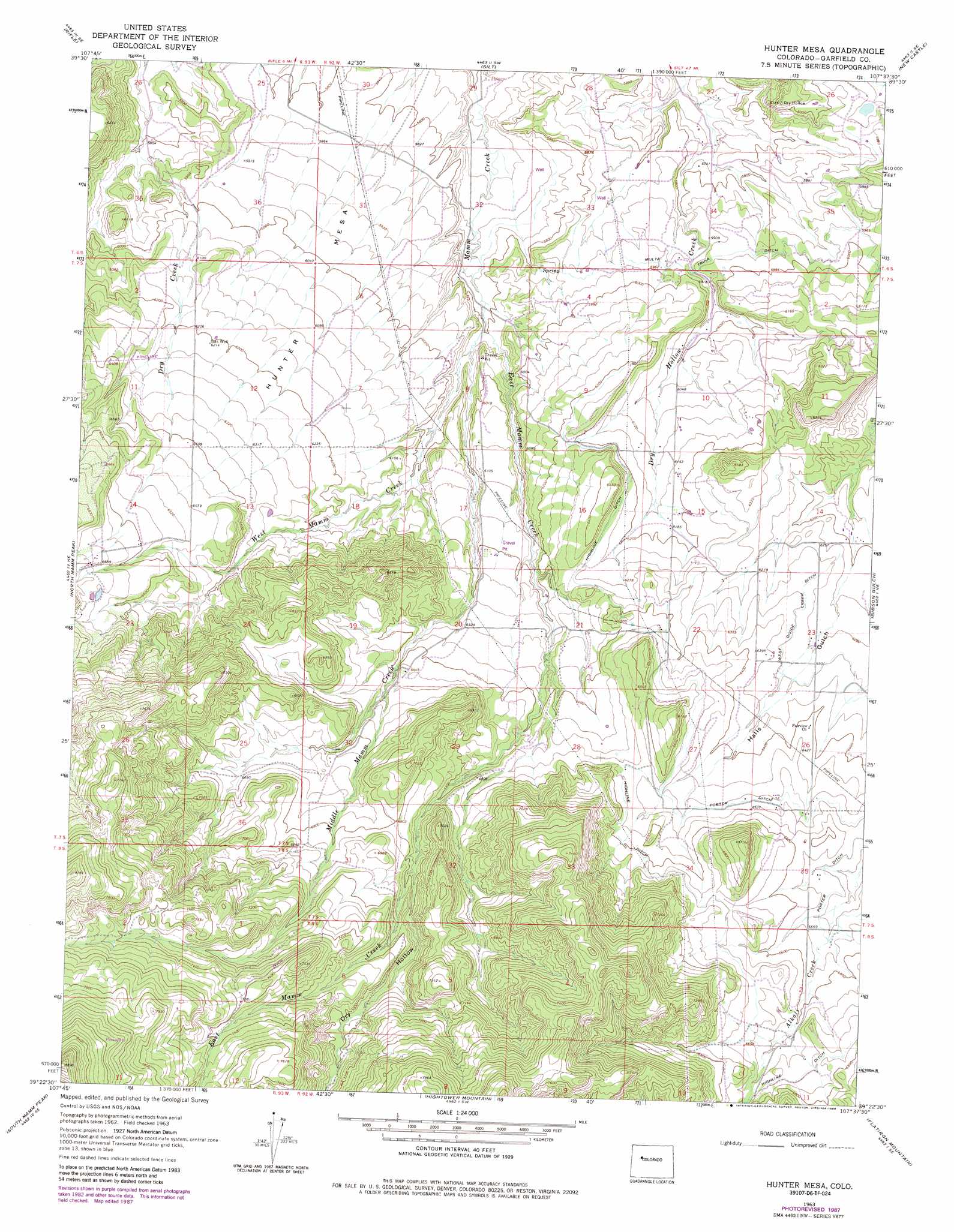
USGS Topo Quad 39107d6 - 1:24,000 scale
| Topo Map Name: | Hunter Mesa |
| USGS Topo Quad ID: | 39107d6 |
| Print Size: | ca. 21 1/4" wide x 27" high |
| Southeast Coordinates: | 39.375° N latitude / 107.625° W longitude |
| Map Center Coordinates: | 39.4375° N latitude / 107.6875° W longitude |
| U.S. State: | CO |
| Filename: | o39107d6.jpg |
| Download Map JPG Image: | Hunter Mesa topo map 1:24,000 scale |
| Map Type: | Topographic |
| Topo Series: | 7.5´ |
| Map Scale: | 1:24,000 |
| Source of Map Images: | United States Geological Survey (USGS) |
| Alternate Map Versions: |
Hunter Mesa CO 1963, updated 1967 Download PDF Buy paper map Hunter Mesa CO 1963, updated 1967 Download PDF Buy paper map Hunter Mesa CO 1963, updated 1984 Download PDF Buy paper map Hunter Mesa CO 1963, updated 1988 Download PDF Buy paper map Hunter Mesa CO 2011 Download PDF Buy paper map Hunter Mesa CO 2013 Download PDF Buy paper map Hunter Mesa CO 2016 Download PDF Buy paper map |
1:24,000 Topo Quads surrounding Hunter Mesa
Rio Blanco |
Horse Mountain |
Rifle Falls |
Deep Creek Point |
Adams Lake |
Anvil Points |
Rifle |
Silt |
New Castle |
Storm King Mountain |
Rulison |
North Mamm Peak |
Hunter Mesa |
Gibson Gulch |
Center Mountain |
Hawxhurst Creek |
South Mamm Peak |
Hightower Mountain |
Flatiron Mountain |
Quaker Mesa |
Collbran |
The Meadows |
Porter Mountain |
Spruce Mountain |
Elk Knob |
> Back to 39107a1 at 1:100,000 scale
> Back to 39106a1 at 1:250,000 scale
> Back to U.S. Topo Maps home
Hunter Mesa topo map: Gazetteer
Hunter Mesa: Canals
Highline Ditch elevation 2017m 6617′Multa Trina Ditch elevation 1814m 5951′
Porter Ditch elevation 1992m 6535′
West Divide Creek Ditch elevation 1927m 6322′
Hunter Mesa: Flats
Coyote Park elevation 1954m 6410′Hunter Mesa: Streams
East Mamm Creek elevation 1769m 5803′Middle Mamm Creek elevation 1776m 5826′
West Mamm Creek elevation 1810m 5938′
Hunter Mesa: Summits
Hunter Mesa elevation 2040m 6692′Hunter Mesa: Valleys
Dry Hollow elevation 2116m 6942′Gant Gulch elevation 1999m 6558′
Halls Gulch elevation 1876m 6154′
Hunter Mesa digital topo map on disk
Buy this Hunter Mesa topo map showing relief, roads, GPS coordinates and other geographical features, as a high-resolution digital map file on DVD: