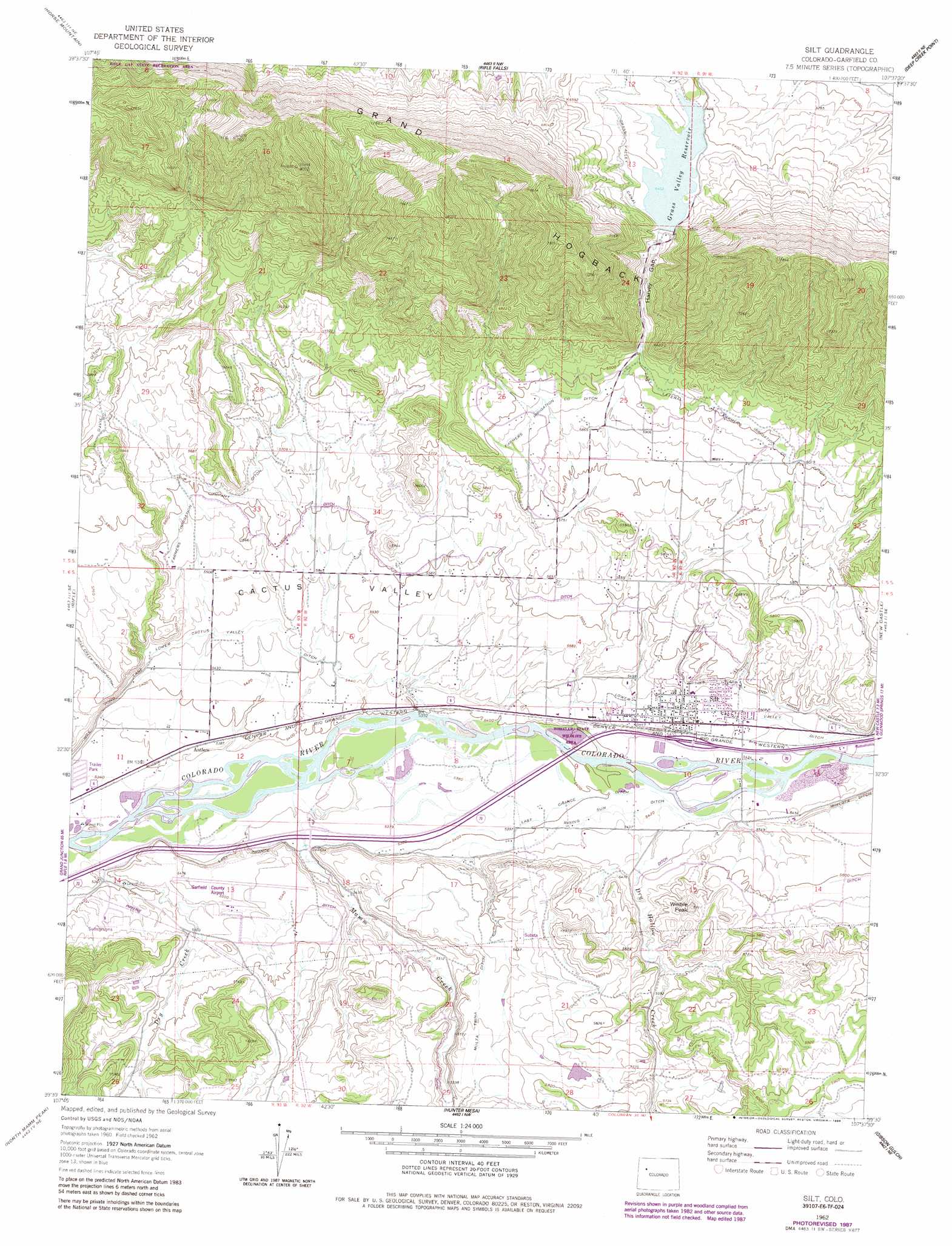
Silt Topo Map Colorado
To zoom in, hover over the map of Silt
USGS Topo Quad 39107e6 - 1:24,000 scale
| Topo Map Name: | Silt |
| USGS Topo Quad ID: | 39107e6 |
| Print Size: | ca. 21 1/4" wide x 27" high |
| Southeast Coordinates: | 39.5° N latitude / 107.625° W longitude |
| Map Center Coordinates: | 39.5625° N latitude / 107.6875° W longitude |
| U.S. State: | CO |
| Filename: | o39107e6.jpg |
| Download Map JPG Image: | Silt topo map 1:24,000 scale |
| Map Type: | Topographic |
| Topo Series: | 7.5´ |
| Map Scale: | 1:24,000 |
| Source of Map Images: | United States Geological Survey (USGS) |
| Alternate Map Versions: |
Silt CO 1962, updated 1964 Download PDF Buy paper map Silt CO 1962, updated 1970 Download PDF Buy paper map Silt CO 1962, updated 1970 Download PDF Buy paper map Silt CO 1962, updated 1984 Download PDF Buy paper map Silt CO 1962, updated 1984 Download PDF Buy paper map Silt CO 1962, updated 1988 Download PDF Buy paper map Silt CO 1962, updated 1988 Download PDF Buy paper map Silt CO 2010 Download PDF Buy paper map Silt CO 2013 Download PDF Buy paper map Silt CO 2016 Download PDF Buy paper map |
1:24,000 Topo Quads surrounding Silt
Thirteenmile Creek |
Red Elephant Point |
Triangle Park |
Meadow Creek Lake |
Blair Mountain |
Rio Blanco |
Horse Mountain |
Rifle Falls |
Deep Creek Point |
Adams Lake |
Anvil Points |
Rifle |
Silt |
New Castle |
Storm King Mountain |
Rulison |
North Mamm Peak |
Hunter Mesa |
Gibson Gulch |
Center Mountain |
Hawxhurst Creek |
South Mamm Peak |
Hightower Mountain |
Flatiron Mountain |
Quaker Mesa |
> Back to 39107e1 at 1:100,000 scale
> Back to 39106a1 at 1:250,000 scale
> Back to U.S. Topo Maps home
Silt topo map: Gazetteer
Silt: Airports
Garfield County Regional Airport elevation 1679m 5508′Rifle Municipal Airport elevation 1685m 5528′
Silt: Basins
Cactus Valley elevation 1691m 5547′Silt: Canals
Davie Ditch elevation 1795m 5889′East Lateral Farmers Irrigation Company Ditch elevation 1834m 6017′
Farmers Irrigation Company Ditch elevation 1740m 5708′
Last Chance Ditch elevation 1643m 5390′
Lower Cactus Valley Ditch elevation 1665m 5462′
Rifle Creek Canyon Ditch elevation 1718m 5636′
Rising Sun Ditch elevation 1651m 5416′
Silt: Dams
Grass Valley Dam elevation 1952m 6404′Rifle Valley Dam elevation 1642m 5387′
Silt: Gaps
Harvey Gap elevation 1889m 6197′Silt: Mines
Black Raven Mine elevation 2155m 7070′Eastside Mine elevation 1669m 5475′
Ingle Haas and Ingle Mine elevation 2150m 7053′
Le Donne Mine elevation 1990m 6528′
Nu Gap Number Three Mine elevation 1895m 6217′
Rifle Pit elevation 1633m 5357′
Tipple Mine elevation 2123m 6965′
Silt: Populated Places
Antlers elevation 1642m 5387′Silt elevation 1663m 5456′
Silt: Reservoirs
Grass Valley Reservoir elevation 1952m 6404′Rifle Valley Reservoir elevation 1642m 5387′
Silt: Streams
Dry Creek elevation 1623m 5324′Dry Hollow Creek elevation 1653m 5423′
Mamm Creek elevation 1633m 5357′
Silt: Summits
Graham Mesa elevation 1819m 5967′Weible Peak elevation 1797m 5895′
Silt digital topo map on disk
Buy this Silt topo map showing relief, roads, GPS coordinates and other geographical features, as a high-resolution digital map file on DVD: