Anvil Points Topo Map Colorado
To zoom in, hover over the map of Anvil Points
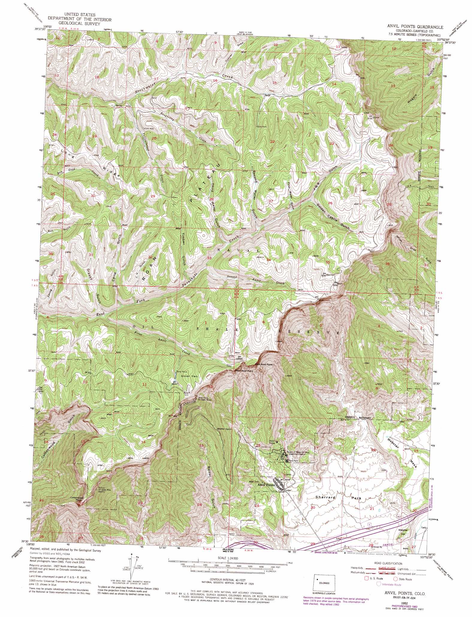
USGS Topo Quad 39107e8 - 1:24,000 scale
| Topo Map Name: | Anvil Points |
| USGS Topo Quad ID: | 39107e8 |
| Print Size: | ca. 21 1/4" wide x 27" high |
| Southeast Coordinates: | 39.5° N latitude / 107.875° W longitude |
| Map Center Coordinates: | 39.5625° N latitude / 107.9375° W longitude |
| U.S. State: | CO |
| Filename: | o39107e8.jpg |
| Download Map JPG Image: | Anvil Points topo map 1:24,000 scale |
| Map Type: | Topographic |
| Topo Series: | 7.5´ |
| Map Scale: | 1:24,000 |
| Source of Map Images: | United States Geological Survey (USGS) |
| Alternate Map Versions: |
Anvil Points CO 1952, updated 1954 Download PDF Buy paper map Anvil Points CO 1952, updated 1954 Download PDF Buy paper map Anvil Points CO 1952, updated 1955 Download PDF Buy paper map Anvil Points CO 1952, updated 1966 Download PDF Buy paper map Anvil Points CO 1952, updated 1966 Download PDF Buy paper map Anvil Points CO 1952, updated 1967 Download PDF Buy paper map Anvil Points CO 1952, updated 1975 Download PDF Buy paper map Anvil Points CO 1952, updated 1984 Download PDF Buy paper map Anvil Points CO 1952, updated 1987 Download PDF Buy paper map Anvil Points CO 2010 Download PDF Buy paper map Anvil Points CO 2013 Download PDF Buy paper map Anvil Points CO 2016 Download PDF Buy paper map |
1:24,000 Topo Quads surrounding Anvil Points
Jessup Gulch |
No Name Ridge |
Thirteenmile Creek |
Red Elephant Point |
Triangle Park |
Cutoff Gulch |
Mccarthy Gulch |
Rio Blanco |
Horse Mountain |
Rifle Falls |
Circle Dot Gulch |
Forked Gulch |
Anvil Points |
Rifle |
Silt |
Red Pinnacle |
Parachute |
Rulison |
North Mamm Peak |
Hunter Mesa |
De Beque |
Housetop Mountain |
Hawxhurst Creek |
South Mamm Peak |
Hightower Mountain |
> Back to 39107e1 at 1:100,000 scale
> Back to 39106a1 at 1:250,000 scale
> Back to U.S. Topo Maps home
Anvil Points topo map: Gazetteer
Anvil Points: Cliffs
Cottonwood Point elevation 2511m 8238′East Anvil Point elevation 2639m 8658′
West Anvil Point elevation 2634m 8641′
Anvil Points: Flats
Glover Park elevation 2685m 8809′Sharrard Park elevation 1626m 5334′
Anvil Points: Mines
Anvil Points Oil Shale Mines elevation 2510m 8234′Rulison Oil Shale Mine elevation 2459m 8067′
Anvil Points: Populated Places
Anvil Points elevation 1723m 5652′Anvil Points: Streams
First Anvil Creek elevation 2500m 8202′Rasberry Creek elevation 2481m 8139′
Second Anvil Creek elevation 2500m 8202′
Yellowjacket Creek elevation 2471m 8106′
Anvil Points: Summits
Roan Plateau elevation 2763m 9064′Webster Hill elevation 1677m 5501′
Webster Mesa elevation 1844m 6049′
Anvil Points: Trails
Doyle Trail elevation 2089m 6853′Anvil Points: Valleys
Balzac Gulch elevation 1602m 5255′Camp Gulch elevation 2424m 7952′
First Water Gulch elevation 2587m 8487′
Golden Castle Gulch elevation 2762m 9061′
Grassy Gulch elevation 2410m 7906′
J Q S Gulch elevation 2586m 8484′
Second Water Gulch elevation 2539m 8330′
Third Water Gulch elevation 2522m 8274′
Tichner Draw elevation 2551m 8369′
Timber Gulch elevation 2499m 8198′
Anvil Points digital topo map on disk
Buy this Anvil Points topo map showing relief, roads, GPS coordinates and other geographical features, as a high-resolution digital map file on DVD: