Deep Creek Point Topo Map Colorado
To zoom in, hover over the map of Deep Creek Point
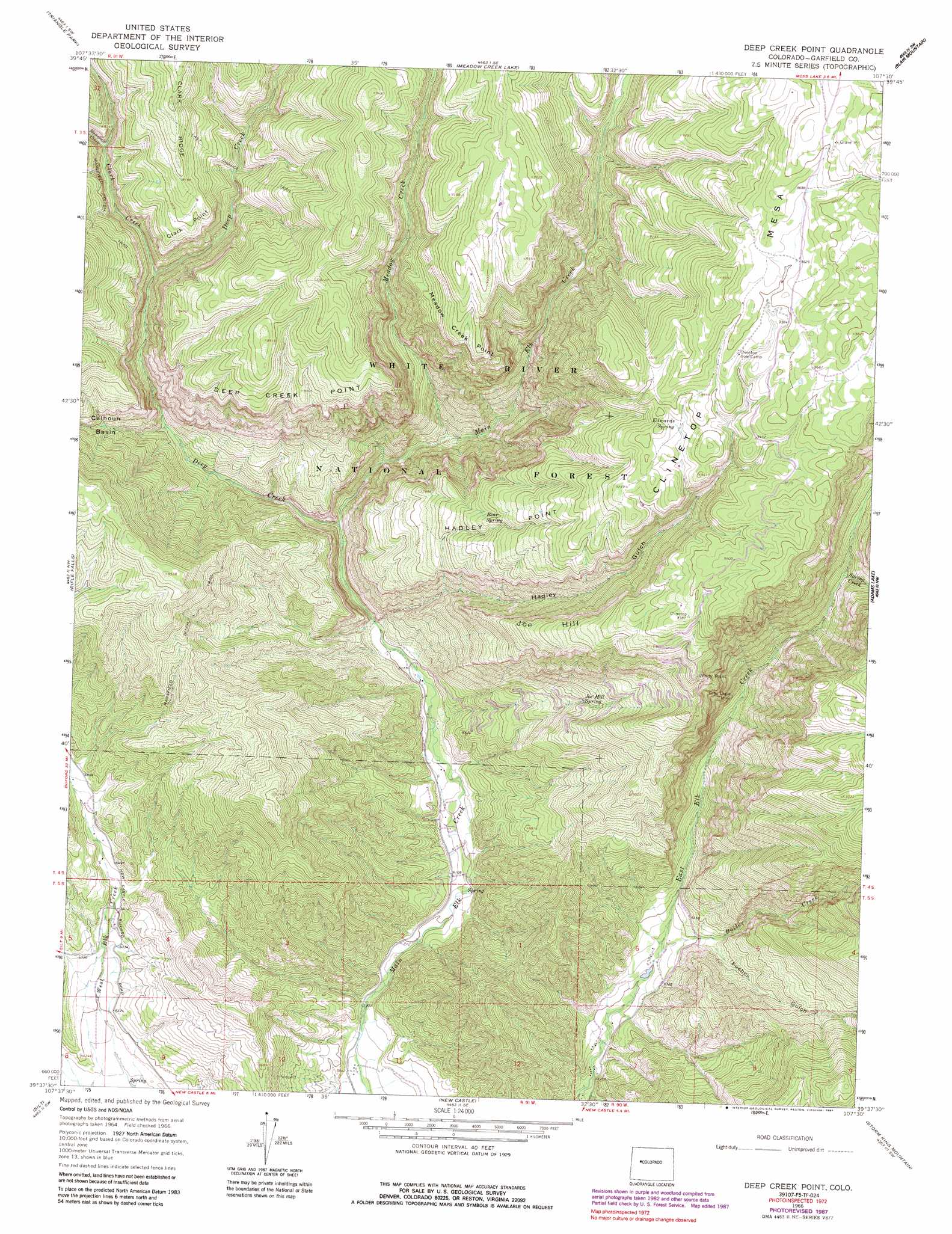
USGS Topo Quad 39107f5 - 1:24,000 scale
| Topo Map Name: | Deep Creek Point |
| USGS Topo Quad ID: | 39107f5 |
| Print Size: | ca. 21 1/4" wide x 27" high |
| Southeast Coordinates: | 39.625° N latitude / 107.5° W longitude |
| Map Center Coordinates: | 39.6875° N latitude / 107.5625° W longitude |
| U.S. State: | CO |
| Filename: | o39107f5.jpg |
| Download Map JPG Image: | Deep Creek Point topo map 1:24,000 scale |
| Map Type: | Topographic |
| Topo Series: | 7.5´ |
| Map Scale: | 1:24,000 |
| Source of Map Images: | United States Geological Survey (USGS) |
| Alternate Map Versions: |
Deep Creek Point CO 1966, updated 1969 Download PDF Buy paper map Deep Creek Point CO 1966, updated 1969 Download PDF Buy paper map Deep Creek Point CO 1966, updated 1970 Download PDF Buy paper map Deep Creek Point CO 1966, updated 1981 Download PDF Buy paper map Deep Creek Point CO 1966, updated 1988 Download PDF Buy paper map Deep Creek Point CO 2011 Download PDF Buy paper map Deep Creek Point CO 2013 Download PDF Buy paper map Deep Creek Point CO 2016 Download PDF Buy paper map |
| FStopo: | US Forest Service topo Deep Creek Point is available: Download FStopo PDF Download FStopo TIF |
1:24,000 Topo Quads surrounding Deep Creek Point
Veatch Gulch |
Big Beaver Reservoir |
Buford |
Oyster Lake |
Big Marvine Peak |
Red Elephant Point |
Triangle Park |
Meadow Creek Lake |
Blair Mountain |
Deep Lake |
Horse Mountain |
Rifle Falls |
Deep Creek Point |
Adams Lake |
Carbonate |
Rifle |
Silt |
New Castle |
Storm King Mountain |
Glenwood Springs |
North Mamm Peak |
Hunter Mesa |
Gibson Gulch |
Center Mountain |
Cattle Creek |
> Back to 39107e1 at 1:100,000 scale
> Back to 39106a1 at 1:250,000 scale
> Back to U.S. Topo Maps home
Deep Creek Point topo map: Gazetteer
Deep Creek Point: Basins
Calhoun Basin elevation 2224m 7296′Deep Creek Point: Cliffs
Clark Point elevation 2573m 8441′Deep Creek Point elevation 2559m 8395′
Meadow Creek Point elevation 2752m 9028′
Windy Point elevation 2659m 8723′
Deep Creek Point: Mines
Gray Eagle Mine elevation 2210m 7250′Deep Creek Point: Ridges
Clark Ridge elevation 2774m 9101′Deep Creek Point: Springs
Bear Spring elevation 2527m 8290′Buttermilk SPring elevation 2922m 9586′
Edwards Spring elevation 2834m 9297′
Joe Hill Spring elevation 2273m 7457′
Prospect Spring elevation 2781m 9124′
Deep Creek Point: Streams
Boiler Creek elevation 1913m 6276′Clark Creek elevation 2322m 7618′
Deep Creek elevation 1935m 6348′
Mansfield Creek elevation 2418m 7933′
Meadow Creek elevation 2001m 6564′
Spring Creek elevation 2435m 7988′
Deep Creek Point: Summits
Hadley Point elevation 2761m 9058′Joe Hill elevation 2808m 9212′
Deep Creek Point: Trails
Last Chance Trail elevation 2469m 8100′Mansfield Ditch Trail elevation 2468m 8097′
Deep Creek Point: Valleys
Fuches Gulch elevation 1977m 6486′Hadley Gulch elevation 1914m 6279′
Deep Creek Point digital topo map on disk
Buy this Deep Creek Point topo map showing relief, roads, GPS coordinates and other geographical features, as a high-resolution digital map file on DVD: