Deep Lake Topo Map Colorado
To zoom in, hover over the map of Deep Lake
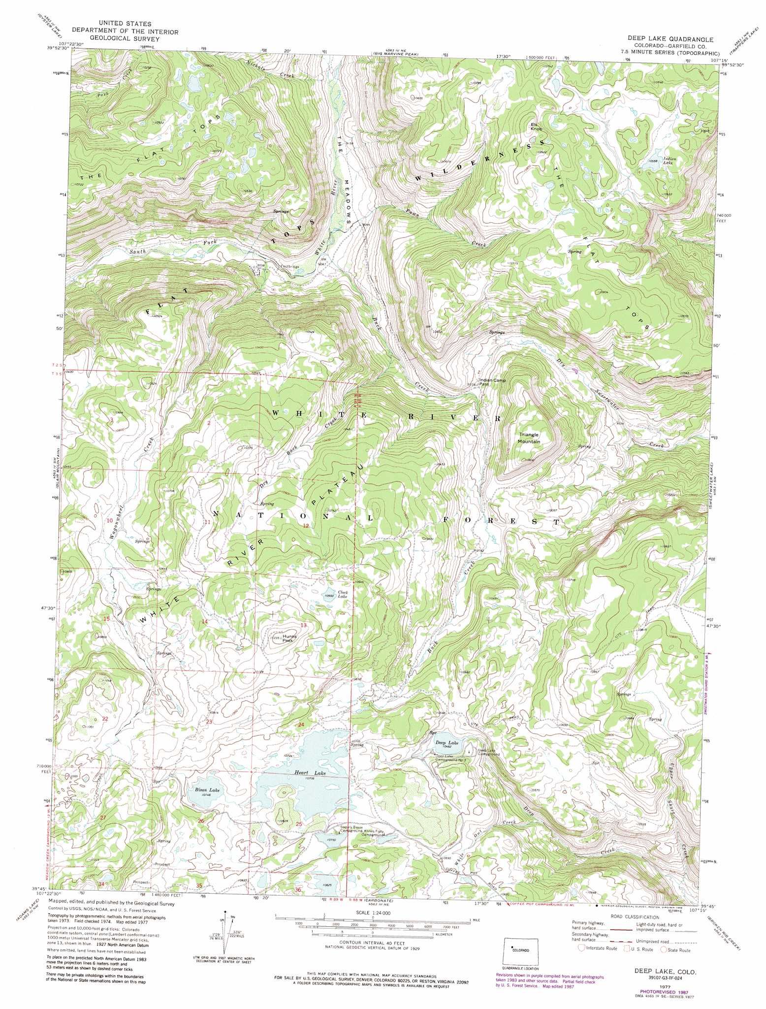
USGS Topo Quad 39107g3 - 1:24,000 scale
| Topo Map Name: | Deep Lake |
| USGS Topo Quad ID: | 39107g3 |
| Print Size: | ca. 21 1/4" wide x 27" high |
| Southeast Coordinates: | 39.75° N latitude / 107.25° W longitude |
| Map Center Coordinates: | 39.8125° N latitude / 107.3125° W longitude |
| U.S. State: | CO |
| Filename: | o39107g3.jpg |
| Download Map JPG Image: | Deep Lake topo map 1:24,000 scale |
| Map Type: | Topographic |
| Topo Series: | 7.5´ |
| Map Scale: | 1:24,000 |
| Source of Map Images: | United States Geological Survey (USGS) |
| Alternate Map Versions: |
Deep Lake CO 1977, updated 1978 Download PDF Buy paper map Deep Lake CO 1977, updated 1988 Download PDF Buy paper map Deep Lake CO 2011 Download PDF Buy paper map Deep Lake CO 2013 Download PDF Buy paper map Deep Lake CO 2016 Download PDF Buy paper map |
| FStopo: | US Forest Service topo Deep Lake is available: Download FStopo PDF Download FStopo TIF |
1:24,000 Topo Quads surrounding Deep Lake
Fawn Creek |
Lost Park |
Ripple Creek |
Devils Causeway |
Orno Peak |
Buford |
Oyster Lake |
Big Marvine Peak |
Trappers Lake |
Dome Peak |
Meadow Creek Lake |
Blair Mountain |
Deep Lake |
Sweetwater Lake |
Sugarloaf Mountain |
Deep Creek Point |
Adams Lake |
Carbonate |
Broken Rib Creek |
Dotsero |
New Castle |
Storm King Mountain |
Glenwood Springs |
Shoshone |
Cottonwood Pass |
> Back to 39107e1 at 1:100,000 scale
> Back to 39106a1 at 1:250,000 scale
> Back to U.S. Topo Maps home
Deep Lake topo map: Gazetteer
Deep Lake: Dams
Bison Lake Dam elevation 3277m 10751′Heart Lake Dam elevation 3264m 10708′
Deep Lake: Gaps
Indian Camp Pass elevation 2973m 9753′Deep Lake: Lakes
Bison Lake elevation 3277m 10751′Clock Lake elevation 3339m 10954′
Deep Lake elevation 3190m 10465′
Indian Lake elevation 3220m 10564′
Deep Lake: Reservoirs
Heart Lake elevation 3265m 10711′Heart Lake Reservoir elevation 3264m 10708′
Deep Lake: Streams
Buck Creek elevation 2755m 9038′Dry Buck Creek elevation 2850m 9350′
Fawn Creek elevation 2757m 9045′
Nichols Creek elevation 2788m 9146′
Upper Short Creek elevation 2899m 9511′
Wagonwheel Creek elevation 2743m 8999′
White Owl Creek elevation 3052m 10013′
Deep Lake: Summits
Elk Knob elevation 3331m 10928′Hunns Peak elevation 3420m 11220′
Triangle Mountain elevation 3231m 10600′
Deep Lake: Valleys
The Meadows elevation 2755m 9038′Deep Lake digital topo map on disk
Buy this Deep Lake topo map showing relief, roads, GPS coordinates and other geographical features, as a high-resolution digital map file on DVD: