Dome Peak Topo Map Colorado
To zoom in, hover over the map of Dome Peak
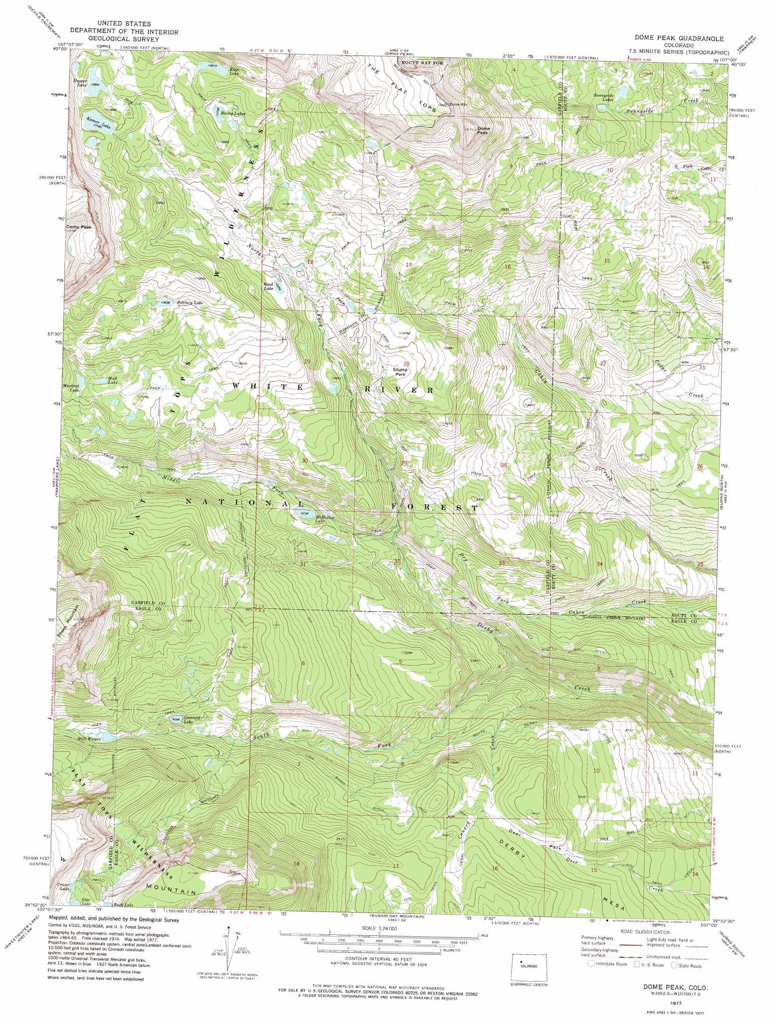
USGS Topo Quad 39107h1 - 1:24,000 scale
| Topo Map Name: | Dome Peak |
| USGS Topo Quad ID: | 39107h1 |
| Print Size: | ca. 21 1/4" wide x 27" high |
| Southeast Coordinates: | 39.875° N latitude / 107° W longitude |
| Map Center Coordinates: | 39.9375° N latitude / 107.0625° W longitude |
| U.S. State: | CO |
| Filename: | o39107h1.jpg |
| Download Map JPG Image: | Dome Peak topo map 1:24,000 scale |
| Map Type: | Topographic |
| Topo Series: | 7.5´ |
| Map Scale: | 1:24,000 |
| Source of Map Images: | United States Geological Survey (USGS) |
| Alternate Map Versions: |
Dome Peak CO 1977, updated 1978 Download PDF Buy paper map Dome Peak CO 2011 Download PDF Buy paper map Dome Peak CO 2013 Download PDF Buy paper map Dome Peak CO 2016 Download PDF Buy paper map |
| FStopo: | US Forest Service topo Dome Peak is available: Download FStopo PDF Download FStopo TIF |
1:24,000 Topo Quads surrounding Dome Peak
Pagoda Peak |
Dunckley Pass |
Sand Point |
Yampa |
Green Ridge |
Ripple Creek |
Devils Causeway |
Orno Peak |
Trapper |
Toponas |
Big Marvine Peak |
Trappers Lake |
Dome Peak |
Burns North |
Blue Hill |
Deep Lake |
Sweetwater Lake |
Sugarloaf Mountain |
Burns South |
Castle Peak |
Carbonate |
Broken Rib Creek |
Dotsero |
Gypsum |
Eagle |
> Back to 39107e1 at 1:100,000 scale
> Back to 39106a1 at 1:250,000 scale
> Back to U.S. Topo Maps home
Dome Peak topo map: Gazetteer
Dome Peak: Canals
Lion Basin Ditch elevation 2867m 9406′South Derby Ditch elevation 2714m 8904′
Dome Peak: Flats
Deer Park elevation 2825m 9268′Stump Park elevation 3073m 10082′
Dome Peak: Gaps
Trail Rider Pass elevation 2966m 9730′Dome Peak: Lakes
Bailey Lakes elevation 3293m 10803′Crater Lake elevation 3360m 11023′
Edge Lake elevation 3328m 10918′
Emerald Lake elevation 2927m 9603′
Keener Lake elevation 3287m 10784′
McMillan Lake elevation 2817m 9242′
Mud Lake elevation 3129m 10265′
Muskrat Lake elevation 3116m 10223′
Road Lake elevation 3112m 10209′
Solitary Lake elevation 3244m 10643′
Star Lake elevation 3360m 11023′
Still Waters elevation 2983m 9786′
Sunnyside Lakes elevation 3167m 10390′
Dome Peak: Streams
Camp Creek elevation 2722m 8930′Canard Creek elevation 2475m 8120′
Middle Fork Derby Creek elevation 2695m 8841′
North Fork Derby Creek elevation 2693m 8835′
South Fork Derby Creek elevation 2510m 8234′
Trail Creek elevation 2694m 8838′
Dome Peak: Summits
Derby Mesa elevation 2880m 9448′Dome Peak elevation 3713m 12181′
Dome Peak digital topo map on disk
Buy this Dome Peak topo map showing relief, roads, GPS coordinates and other geographical features, as a high-resolution digital map file on DVD: