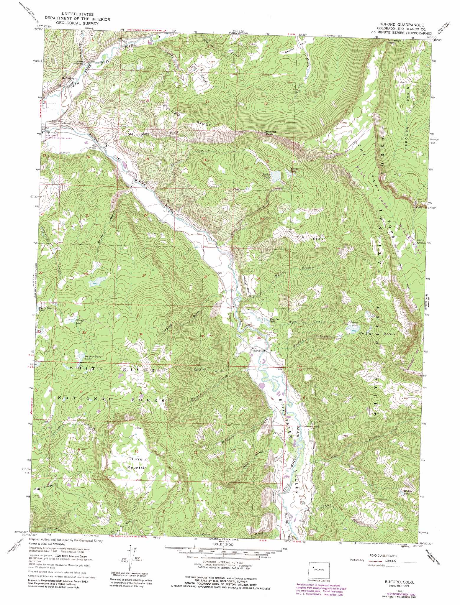
Buford Topo Map Colorado
To zoom in, hover over the map of Buford
USGS Topo Quad 39107h5 - 1:24,000 scale
| Topo Map Name: | Buford |
| USGS Topo Quad ID: | 39107h5 |
| Print Size: | ca. 21 1/4" wide x 27" high |
| Southeast Coordinates: | 39.875° N latitude / 107.5° W longitude |
| Map Center Coordinates: | 39.9375° N latitude / 107.5625° W longitude |
| U.S. State: | CO |
| Filename: | o39107h5.jpg |
| Download Map JPG Image: | Buford topo map 1:24,000 scale |
| Map Type: | Topographic |
| Topo Series: | 7.5´ |
| Map Scale: | 1:24,000 |
| Source of Map Images: | United States Geological Survey (USGS) |
| Alternate Map Versions: |
Buford CO 1966, updated 1970 Download PDF Buy paper map Buford CO 1966, updated 1970 Download PDF Buy paper map Buford CO 1966, updated 1975 Download PDF Buy paper map Buford CO 1966, updated 1988 Download PDF Buy paper map Buford CO 2011 Download PDF Buy paper map Buford CO 2013 Download PDF Buy paper map Buford CO 2016 Download PDF Buy paper map |
| FStopo: | US Forest Service topo Buford is available: Download FStopo PDF Download FStopo TIF |
1:24,000 Topo Quads surrounding Buford
Ninemile Gap |
Thornburgh |
Sleepy Cat Peak |
Slide Creek |
Pagoda Peak |
Rattlesnake Mesa |
Sawmill Mountain |
Fawn Creek |
Lost Park |
Ripple Creek |
Veatch Gulch |
Big Beaver Reservoir |
Buford |
Oyster Lake |
Big Marvine Peak |
Red Elephant Point |
Triangle Park |
Meadow Creek Lake |
Blair Mountain |
Deep Lake |
Horse Mountain |
Rifle Falls |
Deep Creek Point |
Adams Lake |
Carbonate |
> Back to 39107e1 at 1:100,000 scale
> Back to 39106a1 at 1:250,000 scale
> Back to U.S. Topo Maps home
Buford topo map: Gazetteer
Buford: Basins
Peltier Basin elevation 2803m 9196′Buford: Benches
Langlas Bench elevation 2306m 7565′Buford: Canals
Beckman Ditch elevation 2320m 7611′Buford: Cliffs
Nimerick Point elevation 3014m 9888′Buford: Dams
Bailey Lake Dam elevation 2686m 8812′Buford: Flats
Crooks Park elevation 2538m 8326′Buford: Lakes
Harker Park Lake elevation 2709m 8887′Peltier Lake elevation 2712m 8897′
Sterry Lake elevation 2620m 8595′
Wilbur Lake elevation 2801m 9189′
Buford: Populated Places
Buford elevation 2142m 7027′Buford: Reservoirs
Bailey Lake elevation 2677m 8782′Bar-Bel Lake elevation 2310m 7578′
Buford: Ridges
Buford Ridge elevation 2662m 8733′J K Ridge elevation 2743m 8999′
Buford: Streams
Beckman Creek elevation 2309m 7575′Buckeye Creek elevation 2167m 7109′
Cattle Creek elevation 2161m 7089′
Cave Creek elevation 2304m 7559′
Fowler Creek elevation 2303m 7555′
Gooseberry Creek elevation 2139m 7017′
Hazard Creek elevation 2282m 7486′
Hill Creek elevation 2287m 7503′
Moose Creek elevation 2303m 7555′
Old Mans Creek elevation 2145m 7037′
Peltier Creek elevation 2284m 7493′
Swede Creek elevation 2195m 7201′
Ward Creek elevation 2271m 7450′
White Creek elevation 2233m 7326′
Buford: Summits
Buford Peak elevation 2940m 9645′Burro Mountain elevation 3098m 10164′
Buford: Swamps
White Springs elevation 3182m 10439′Buford: Trails
Bailey Lake Trail elevation 2681m 8795′Buford: Valleys
Bear Gulch elevation 2318m 7604′Langlas Draw elevation 2246m 7368′
Missoo Gulch elevation 2252m 7388′
Smith Gulch elevation 2187m 7175′
South Fork Canyon elevation 2302m 7552′
Stillwater Valley elevation 2257m 7404′
Buford digital topo map on disk
Buy this Buford topo map showing relief, roads, GPS coordinates and other geographical features, as a high-resolution digital map file on DVD: