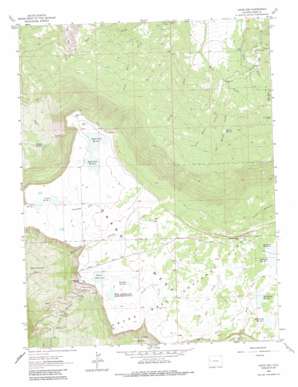
Lands End Topo Map Colorado
To zoom in, hover over the map of Lands End
USGS Topo Quad 39108a2 - 1:24,000 scale
| Topo Map Name: | Lands End |
| USGS Topo Quad ID: | 39108a2 |
| Print Size: | ca. 21 1/4" wide x 27" high |
| Southeast Coordinates: | 39° N latitude / 108.125° W longitude |
| Map Center Coordinates: | 39.0625° N latitude / 108.1875° W longitude |
| U.S. State: | CO |
| Filename: | o39108a2.jpg |
| Download Map JPG Image: | Lands End topo map 1:24,000 scale |
| Map Type: | Topographic |
| Topo Series: | 7.5´ |
| Map Scale: | 1:24,000 |
| Source of Map Images: | United States Geological Survey (USGS) |
| Alternate Map Versions: |
Lands End CO 1962, updated 1964 Download PDF Buy paper map Lands End CO 1962, updated 1971 Download PDF Buy paper map Lands End CO 1962, updated 1971 Download PDF Buy paper map Lands End CO 1962, updated 1985 Download PDF Buy paper map Lands End CO 2011 Download PDF Buy paper map Lands End CO 2013 Download PDF Buy paper map Lands End CO 2016 Download PDF Buy paper map |
| FStopo: | US Forest Service topo Lands End is available: Download FStopo PDF Download FStopo TIF |
1:24,000 Topo Quads surrounding Lands End
> Back to 39108a1 at 1:100,000 scale
> Back to 39108a1 at 1:250,000 scale
> Back to U.S. Topo Maps home
Lands End topo map: Gazetteer
Lands End: Airports
Lands End Microwave Heliport elevation 3043m 9983′Lands End: Basins
Whitewater Basin elevation 2456m 8057′Lands End: Canals
South Side Canal elevation 2116m 6942′Lands End: Cliffs
Lands End elevation 3035m 9957′Lands End: Dams
Anderson Number 1 Dam elevation 3147m 10324′Anderson Number 2 Dam elevation 3153m 10344′
Anderson Number 6 Dam elevation 3036m 9960′
Bolen Dam elevation 3031m 9944′
Bolen, Anderson, Jacobs Number 2 Dam elevation 3025m 9924′
Deep Creek Number 2 Dam elevation 3108m 10196′
Hallenbeck Number 2 Dam elevation 3115m 10219′
Rapid Creek Number 1 Dam elevation 3031m 9944′
Rapid Creek Number 2 Dam elevation 3037m 9963′
Somerville-McCullah Dam elevation 3023m 9917′
Vincent Number 1 Dam elevation 3017m 9898′
Vincent Number 2 Dam elevation 3020m 9908′
Lands End: Reservoirs
Anderson Reservoir Number 1 elevation 3147m 10324′Anderson Reservoir Number 2 elevation 3153m 10344′
Anderson Reservoir Number 6 elevation 3037m 9963′
Bolen Reservoir elevation 3031m 9944′
Bolen, Anderson, and Jacobs Reservoir Number 2 elevation 3025m 9924′
Bolen, Anderson, Jocobs Reservoir Number 2 elevation 3026m 9927′
Deep Creek Reservoir Number 2 elevation 3108m 10196′
Hallenbeck Reservoir Number 2 elevation 3115m 10219′
Hollenbeck Reservoir Number 2 elevation 3117m 10226′
Palisade Reservoir Number 3 elevation 2536m 8320′
Rapid Creek Reservoir Number 1 elevation 3031m 9944′
Rapid Creek Reservoir Number 2 elevation 3037m 9963′
Robbins Reservoir elevation 2312m 7585′
Somerville-McCullah Reservoir elevation 3023m 9917′
Vincent Reservoir Number 1 elevation 3018m 9901′
Vincent Reservoir Number 2 elevation 3020m 9908′
Vincent Reservoirs elevation 3026m 9927′
Lands End: Streams
Big Beaver Creek elevation 2133m 6998′Little Beaver Creek elevation 2105m 6906′
South Tate Creek elevation 2033m 6669′
Willow Creek elevation 2009m 6591′
Lands End: Trails
West Bench Trail elevation 2984m 9790′Lands End digital topo map on disk
Buy this Lands End topo map showing relief, roads, GPS coordinates and other geographical features, as a high-resolution digital map file on DVD:


