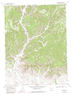
Carbonera Topo Map Colorado
To zoom in, hover over the map of Carbonera
USGS Topo Quad 39108d8 - 1:24,000 scale
| Topo Map Name: | Carbonera |
| USGS Topo Quad ID: | 39108d8 |
| Print Size: | ca. 21 1/4" wide x 27" high |
| Southeast Coordinates: | 39.375° N latitude / 108.875° W longitude |
| Map Center Coordinates: | 39.4375° N latitude / 108.9375° W longitude |
| U.S. State: | CO |
| Filename: | o39108d8.jpg |
| Download Map JPG Image: | Carbonera topo map 1:24,000 scale |
| Map Type: | Topographic |
| Topo Series: | 7.5´ |
| Map Scale: | 1:24,000 |
| Source of Map Images: | United States Geological Survey (USGS) |
| Alternate Map Versions: |
Carbonera CO 1968, updated 1971 Download PDF Buy paper map Carbonera CO 1968, updated 1971 Download PDF Buy paper map Carbonera CO 1968, updated 1981 Download PDF Buy paper map Carbonera CO 2010 Download PDF Buy paper map Carbonera CO 2013 Download PDF Buy paper map Carbonera CO 2016 Download PDF Buy paper map |
1:24,000 Topo Quads surrounding Carbonera
> Back to 39108a1 at 1:100,000 scale
> Back to 39108a1 at 1:250,000 scale
> Back to U.S. Topo Maps home
Carbonera topo map: Gazetteer
Carbonera: Populated Places
Carbonera elevation 1681m 5515′Carbonera: Summits
Grassy Mountain elevation 2077m 6814′Carbonera: Valleys
Buttermilk Canyon elevation 1758m 5767′Long Canyon elevation 1789m 5869′
South Canyon elevation 1655m 5429′
Spring Canyon elevation 1730m 5675′
Spring Canyon elevation 1798m 5898′
Carbonera digital topo map on disk
Buy this Carbonera topo map showing relief, roads, GPS coordinates and other geographical features, as a high-resolution digital map file on DVD:


