Mccarthy Gulch Topo Map Colorado
To zoom in, hover over the map of Mccarthy Gulch
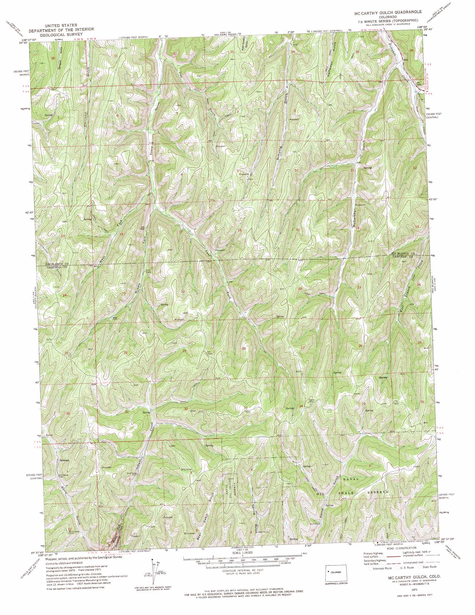
USGS Topo Quad 39108f1 - 1:24,000 scale
| Topo Map Name: | Mccarthy Gulch |
| USGS Topo Quad ID: | 39108f1 |
| Print Size: | ca. 21 1/4" wide x 27" high |
| Southeast Coordinates: | 39.625° N latitude / 108° W longitude |
| Map Center Coordinates: | 39.6875° N latitude / 108.0625° W longitude |
| U.S. State: | CO |
| Filename: | o39108f1.jpg |
| Download Map JPG Image: | Mccarthy Gulch topo map 1:24,000 scale |
| Map Type: | Topographic |
| Topo Series: | 7.5´ |
| Map Scale: | 1:24,000 |
| Source of Map Images: | United States Geological Survey (USGS) |
| Alternate Map Versions: |
McCarthy Gulch CO 1971, updated 1974 Download PDF Buy paper map McCarthy Gulch CO 1971, updated 1974 Download PDF Buy paper map McCarthy Gulch CO 2010 Download PDF Buy paper map McCarthy Gulch CO 2013 Download PDF Buy paper map McCarthy Gulch CO 2016 Download PDF Buy paper map |
1:24,000 Topo Quads surrounding Mccarthy Gulch
Square S Ranch |
Greasewood Gulch |
Segar Mountain |
Lo 7 Hill |
Veatch Gulch |
Rock School |
Jessup Gulch |
No Name Ridge |
Thirteenmile Creek |
Red Elephant Point |
Bull Fork |
Cutoff Gulch |
Mccarthy Gulch |
Rio Blanco |
Horse Mountain |
Mount Blaine |
Circle Dot Gulch |
Forked Gulch |
Anvil Points |
Rifle |
Long Point |
Red Pinnacle |
Parachute |
Rulison |
North Mamm Peak |
> Back to 39108e1 at 1:100,000 scale
> Back to 39108a1 at 1:250,000 scale
> Back to U.S. Topo Maps home
Mccarthy Gulch topo map: Gazetteer
Mccarthy Gulch: Streams
Cow Creek elevation 2129m 6984′Schutte Creek elevation 2227m 7306′
Mccarthy Gulch: Valleys
East Fork Story Gulch elevation 2196m 7204′Hay Gulch elevation 2131m 6991′
McCarthy Gulch elevation 2119m 6952′
Middle Fork Story Gulch elevation 2196m 7204′
West Fork Story Gulch elevation 2191m 7188′
Mccarthy Gulch digital topo map on disk
Buy this Mccarthy Gulch topo map showing relief, roads, GPS coordinates and other geographical features, as a high-resolution digital map file on DVD: