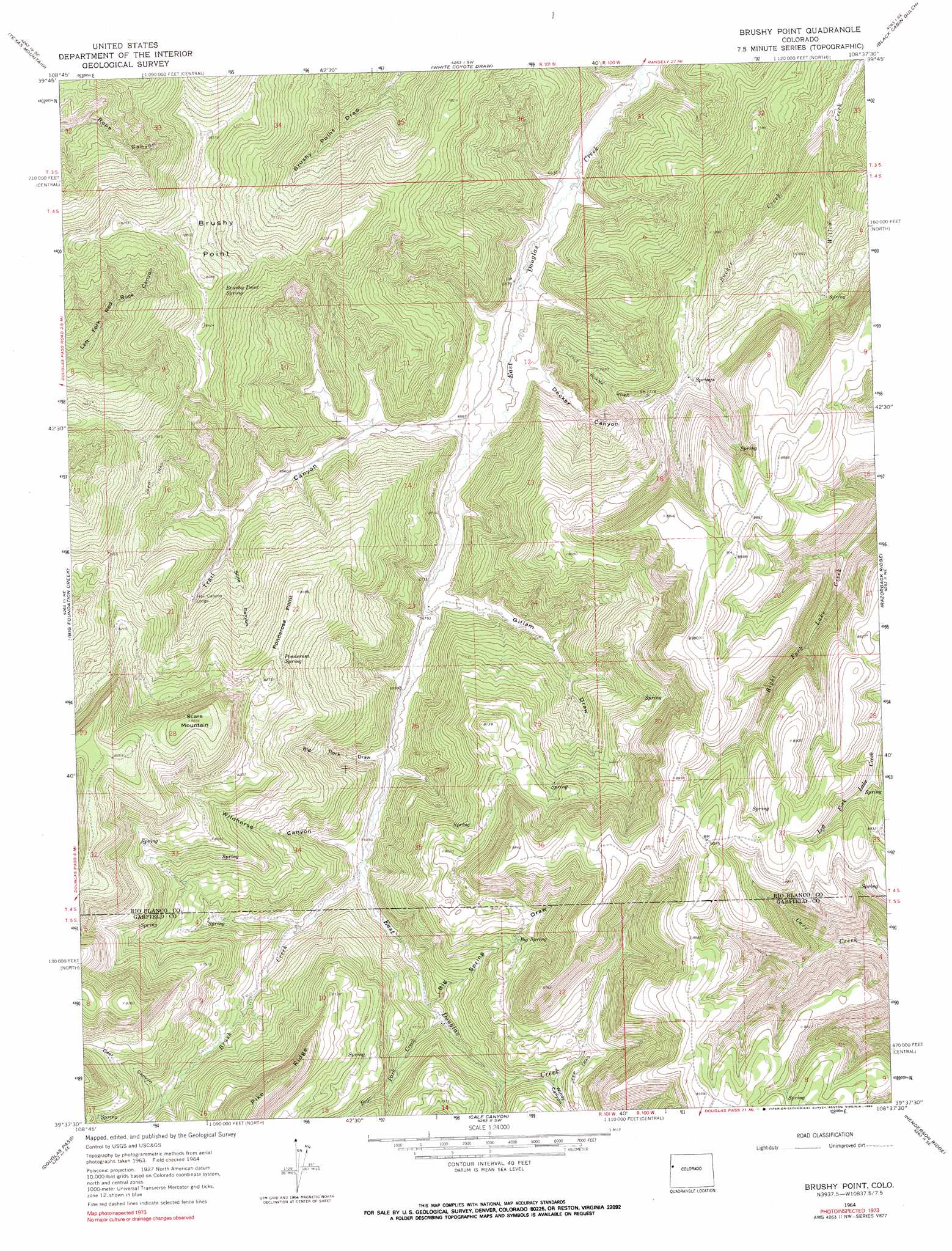
Brushy Point Topo Map Colorado
To zoom in, hover over the map of Brushy Point
USGS Topo Quad 39108f6 - 1:24,000 scale
| Topo Map Name: | Brushy Point |
| USGS Topo Quad ID: | 39108f6 |
| Print Size: | ca. 21 1/4" wide x 27" high |
| Southeast Coordinates: | 39.625° N latitude / 108.625° W longitude |
| Map Center Coordinates: | 39.6875° N latitude / 108.6875° W longitude |
| U.S. State: | CO |
| Filename: | o39108f6.jpg |
| Download Map JPG Image: | Brushy Point topo map 1:24,000 scale |
| Map Type: | Topographic |
| Topo Series: | 7.5´ |
| Map Scale: | 1:24,000 |
| Source of Map Images: | United States Geological Survey (USGS) |
| Alternate Map Versions: |
Brushy Point CO 1964, updated 1968 Download PDF Buy paper map Brushy Point CO 1964, updated 1968 Download PDF Buy paper map Brushy Point CO 1964, updated 1990 Download PDF Buy paper map Brushy Point CO 1964, updated 1990 Download PDF Buy paper map Brushy Point CO 2010 Download PDF Buy paper map Brushy Point CO 2013 Download PDF Buy paper map Brushy Point CO 2016 Download PDF Buy paper map |
1:24,000 Topo Quads surrounding Brushy Point
Banta Ridge |
Water Canyon |
Philadelphia Creek |
Sagebrush Hill |
Wolf Ridge |
Texas Creek |
Texas Mountain |
White Coyote Draw |
Black Cabin Gulch |
Yankee Gulch |
East Evacuation Creek |
Big Foundation Creek |
Brushy Point |
Razorback Ridge |
Figure Four Spring |
Baxter Pass |
Douglas Pass |
Calf Canyon |
Henderson Ridge |
Desert Gulch |
Carbonera |
Howard Canyon |
Garvey Canyon |
Middle Dry Fork |
The Saddle |
> Back to 39108e1 at 1:100,000 scale
> Back to 39108a1 at 1:250,000 scale
> Back to U.S. Topo Maps home
Brushy Point topo map: Gazetteer
Brushy Point: Cliffs
Ponderosa Point elevation 2493m 8179′Brushy Point: Mines
Sunkirk Mine elevation 2263m 7424′Brushy Point: Springs
Big Spring elevation 2364m 7755′Brushy Point Spring elevation 2525m 8284′
Ponderosa Spring elevation 2470m 8103′
Brushy Point: Streams
Bear Park Creek elevation 2151m 7057′Brush Creek elevation 2103m 6899′
East Fork Bear Park Creek elevation 2230m 7316′
Sucker Creek elevation 2070m 6791′
Brushy Point: Summits
Brushy Point elevation 2590m 8497′Scare Mountain elevation 2704m 8871′
Brushy Point: Valleys
Big Rock Draw elevation 2087m 6847′Big Spring Draw elevation 2146m 7040′
Decker Canyon elevation 2020m 6627′
Deer Canyon elevation 2270m 7447′
Gillam Draw elevation 2066m 6778′
Slide Canyon elevation 2174m 7132′
Trail Canyon elevation 2037m 6683′
Wildhorse Canyon elevation 2107m 6912′
Windy Canyon elevation 2266m 7434′
Brushy Point digital topo map on disk
Buy this Brushy Point topo map showing relief, roads, GPS coordinates and other geographical features, as a high-resolution digital map file on DVD: