Sagebrush Hill Topo Map Colorado
To zoom in, hover over the map of Sagebrush Hill
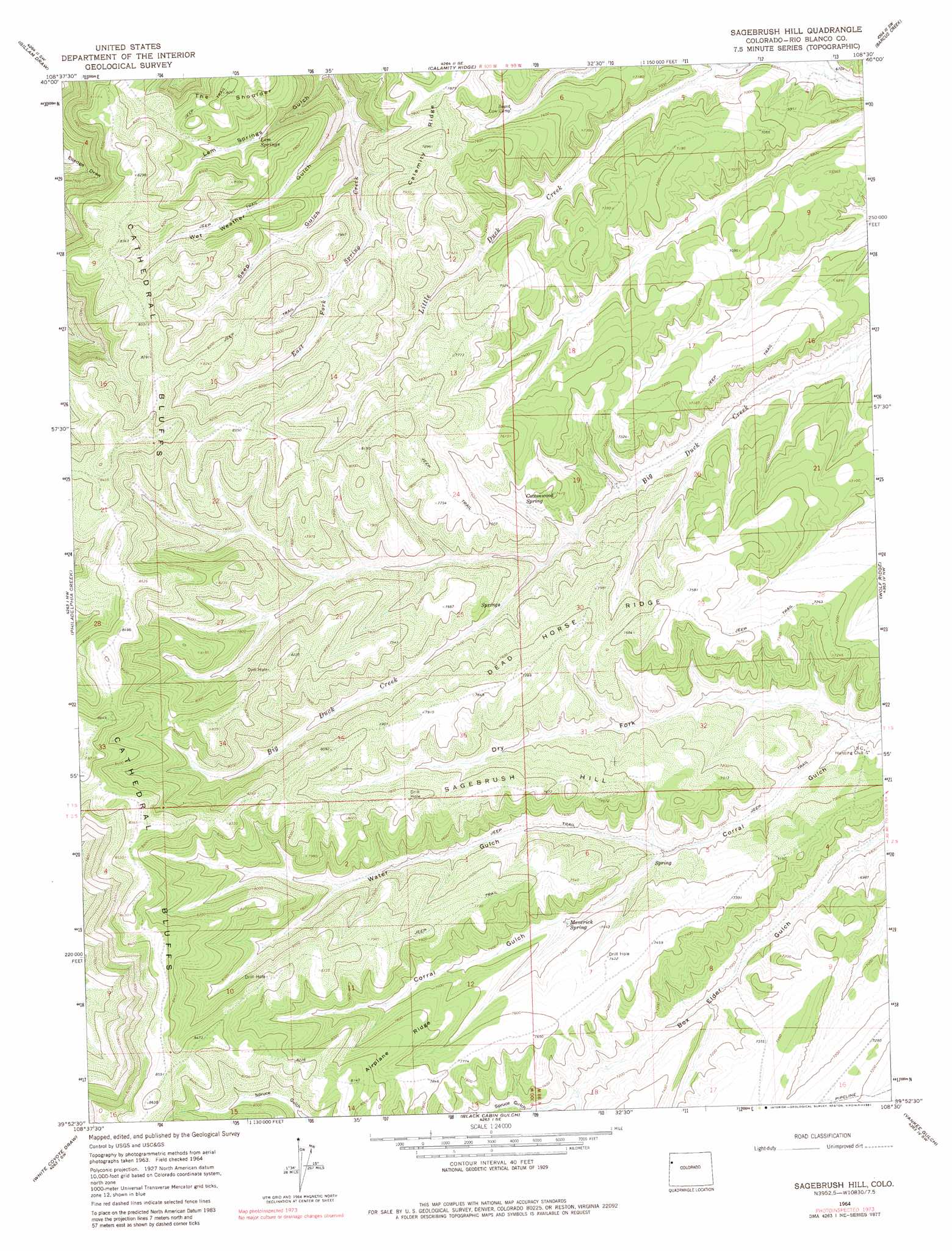
USGS Topo Quad 39108h5 - 1:24,000 scale
| Topo Map Name: | Sagebrush Hill |
| USGS Topo Quad ID: | 39108h5 |
| Print Size: | ca. 21 1/4" wide x 27" high |
| Southeast Coordinates: | 39.875° N latitude / 108.5° W longitude |
| Map Center Coordinates: | 39.9375° N latitude / 108.5625° W longitude |
| U.S. State: | CO |
| Filename: | o39108h5.jpg |
| Download Map JPG Image: | Sagebrush Hill topo map 1:24,000 scale |
| Map Type: | Topographic |
| Topo Series: | 7.5´ |
| Map Scale: | 1:24,000 |
| Source of Map Images: | United States Geological Survey (USGS) |
| Alternate Map Versions: |
Sagebrush Hill CO 1964, updated 1968 Download PDF Buy paper map Sagebrush Hill CO 1964, updated 1981 Download PDF Buy paper map Sagebrush Hill CO 2010 Download PDF Buy paper map Sagebrush Hill CO 2013 Download PDF Buy paper map Sagebrush Hill CO 2016 Download PDF Buy paper map |
1:24,000 Topo Quads surrounding Sagebrush Hill
Rangely Ne |
Cactus Reservoir |
Divide Creek |
Rough Gulch |
Smizer Gulch |
Rangely |
Gillam Draw |
Calamity Ridge |
Barcus Creek |
Barcus Creek Se |
Water Canyon |
Philadelphia Creek |
Sagebrush Hill |
Wolf Ridge |
Square S Ranch |
Texas Mountain |
White Coyote Draw |
Black Cabin Gulch |
Yankee Gulch |
Rock School |
Big Foundation Creek |
Brushy Point |
Razorback Ridge |
Figure Four Spring |
Bull Fork |
> Back to 39108e1 at 1:100,000 scale
> Back to 39108a1 at 1:250,000 scale
> Back to U.S. Topo Maps home
Sagebrush Hill topo map: Gazetteer
Sagebrush Hill: Airports
Tract C-A Heliport elevation 2110m 6922′Sagebrush Hill: Dams
Blowdown Water Storage Dam elevation 2090m 6856′Sagebrush Hill: Reservoirs
Blowdown Water Storage Reservoir elevation 2090m 6856′Sagebrush Hill: Ridges
Airplane Ridge elevation 2408m 7900′Dead Horse Ridge elevation 2312m 7585′
Sagebrush Hill: Springs
Cottonwood Spring elevation 2232m 7322′Lem Springs elevation 2319m 7608′
Maverick Spring elevation 2196m 7204′
Sagebrush Hill: Summits
Sagebrush Hill elevation 2337m 7667′Sagebrush Hill: Valleys
Buckhorn Draw elevation 2087m 6847′Dry Fork Corral Gulch elevation 2061m 6761′
Lem Springs Gulch elevation 2137m 7011′
Seep Gulch elevation 2249m 7378′
Spruce Gulch elevation 2193m 7194′
Water Gulch elevation 2141m 7024′
Wet Weather Gulch elevation 2173m 7129′
Sagebrush Hill digital topo map on disk
Buy this Sagebrush Hill topo map showing relief, roads, GPS coordinates and other geographical features, as a high-resolution digital map file on DVD: