Water Canyon Topo Map Colorado
To zoom in, hover over the map of Water Canyon
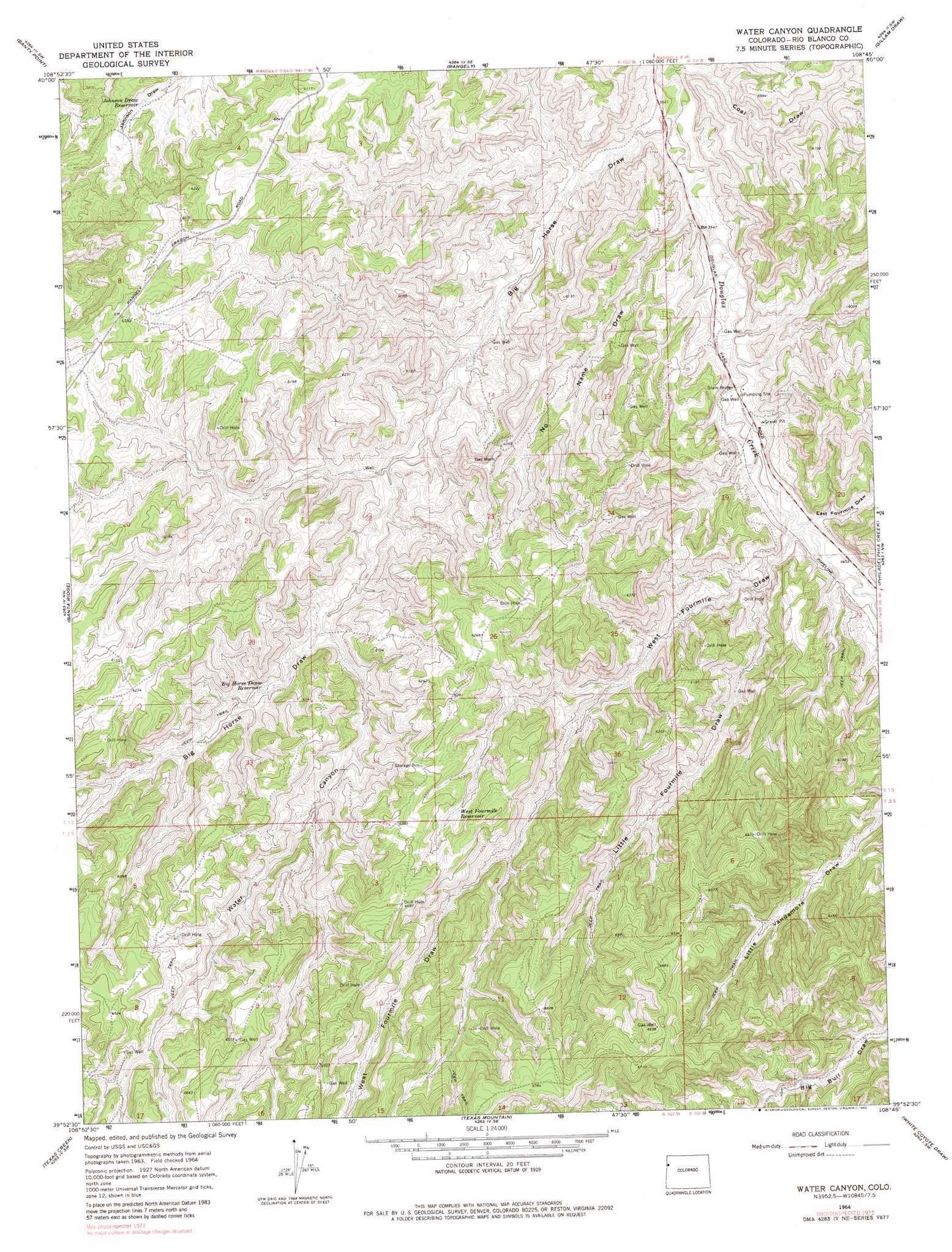
USGS Topo Quad 39108h7 - 1:24,000 scale
| Topo Map Name: | Water Canyon |
| USGS Topo Quad ID: | 39108h7 |
| Print Size: | ca. 21 1/4" wide x 27" high |
| Southeast Coordinates: | 39.875° N latitude / 108.75° W longitude |
| Map Center Coordinates: | 39.9375° N latitude / 108.8125° W longitude |
| U.S. State: | CO |
| Filename: | o39108h7.jpg |
| Download Map JPG Image: | Water Canyon topo map 1:24,000 scale |
| Map Type: | Topographic |
| Topo Series: | 7.5´ |
| Map Scale: | 1:24,000 |
| Source of Map Images: | United States Geological Survey (USGS) |
| Alternate Map Versions: |
Water Canyon CO 1964, updated 1968 Download PDF Buy paper map Water Canyon CO 1964, updated 1968 Download PDF Buy paper map Water Canyon CO 1964, updated 1982 Download PDF Buy paper map Water Canyon CO 2010 Download PDF Buy paper map Water Canyon CO 2013 Download PDF Buy paper map Water Canyon CO 2016 Download PDF Buy paper map |
1:24,000 Topo Quads surrounding Water Canyon
Dinosaur |
Mellen Hill |
Rangely Ne |
Cactus Reservoir |
Divide Creek |
Walsh Knolls |
Banty Point |
Rangely |
Gillam Draw |
Calamity Ridge |
Weaver Ridge |
Banta Ridge |
Water Canyon |
Philadelphia Creek |
Sagebrush Hill |
Dragon |
Texas Creek |
Texas Mountain |
White Coyote Draw |
Black Cabin Gulch |
Davis Canyon |
East Evacuation Creek |
Big Foundation Creek |
Brushy Point |
Razorback Ridge |
> Back to 39108e1 at 1:100,000 scale
> Back to 39108a1 at 1:250,000 scale
> Back to U.S. Topo Maps home
Water Canyon topo map: Gazetteer
Water Canyon: Reservoirs
Big Horse Draw Reservoir elevation 1796m 5892′Johnson Draw Reservoir elevation 1787m 5862′
West Fourmile Reservoir elevation 1899m 6230′
Water Canyon: Valleys
Big Horse Draw elevation 1674m 5492′Coal Draw elevation 1673m 5488′
East Fourmile Draw elevation 1719m 5639′
Little Fourmile Draw elevation 1733m 5685′
Little Vandamore Draw elevation 1831m 6007′
No Name Draw elevation 1937m 6354′
Water Canyon elevation 1804m 5918′
West Fourmile Draw elevation 1724m 5656′
Water Canyon digital topo map on disk
Buy this Water Canyon topo map showing relief, roads, GPS coordinates and other geographical features, as a high-resolution digital map file on DVD: