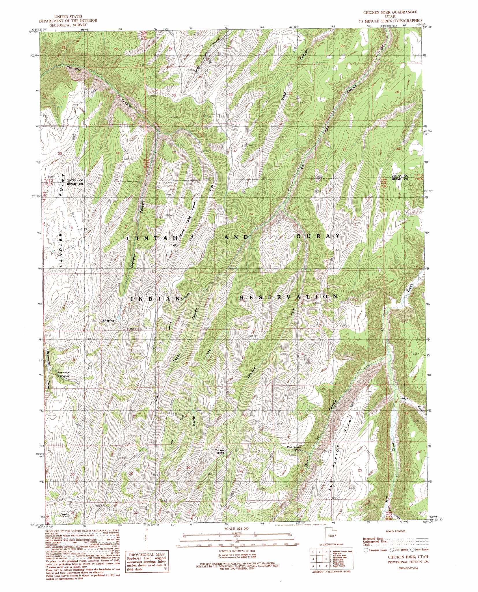
Chicken Fork Topo Map Utah
To zoom in, hover over the map of Chicken Fork
USGS Topo Quad 39109d7 - 1:24,000 scale
| Topo Map Name: | Chicken Fork |
| USGS Topo Quad ID: | 39109d7 |
| Print Size: | ca. 21 1/4" wide x 27" high |
| Southeast Coordinates: | 39.375° N latitude / 109.75° W longitude |
| Map Center Coordinates: | 39.4375° N latitude / 109.8125° W longitude |
| U.S. State: | UT |
| Filename: | o39109d7.jpg |
| Download Map JPG Image: | Chicken Fork topo map 1:24,000 scale |
| Map Type: | Topographic |
| Topo Series: | 7.5´ |
| Map Scale: | 1:24,000 |
| Source of Map Images: | United States Geological Survey (USGS) |
| Alternate Map Versions: |
Checken Fork UT 1991, updated 1991 Download PDF Buy paper map Chicken Fork UT 2011 Download PDF Buy paper map Chicken Fork UT 2014 Download PDF Buy paper map |
1:24,000 Topo Quads surrounding Chicken Fork
Cedar Ridge Canyon |
Firewater Canyon North |
Dog Knoll |
Agency Draw Nw |
Agency Draw Ne |
Steer Ridge Canyon |
Firewater Canyon South |
Wolf Flat |
Flat Rock Mesa |
Wolf Point |
Chandler Falls |
Moonwater Point |
Chicken Fork |
Black Knolls |
Tenmile Canyon North |
Three Fords Canyon |
Lion Canyon |
Walker Point |
Supply Canyon |
Tenmile Canyon South |
Butler Canyon |
Bobby Canyon North |
Floy Canyon North |
Bogart Canyon |
Tepee Canyon |
> Back to 39109a1 at 1:100,000 scale
> Back to 39108a1 at 1:250,000 scale
> Back to U.S. Topo Maps home
Chicken Fork topo map: Gazetteer
Chicken Fork: Capes
Cnandler Point elevation 2429m 7969′No Mans Land Point elevation 2587m 8487′
Chicken Fork: Springs
BP Spring elevation 2442m 8011′Chicken Spring elevation 2487m 8159′
Moonwater Springs elevation 2445m 8021′
Post Canyon Spring elevation 2336m 7664′
Chicken Fork: Streams
Chicken Fork elevation 2250m 7381′Corral Creek elevation 2132m 6994′
Dry Fork elevation 2478m 8129′
Harris Fork elevation 2300m 7545′
Spring Creek elevation 2176m 7139′
Chicken Fork: Valleys
East Fork Chandler Canyon elevation 2212m 7257′Post Canyon elevation 2121m 6958′
Short Canyon elevation 2370m 7775′
Chicken Fork digital topo map on disk
Buy this Chicken Fork topo map showing relief, roads, GPS coordinates and other geographical features, as a high-resolution digital map file on DVD: