Pine Spring Canyon Topo Map Utah
To zoom in, hover over the map of Pine Spring Canyon
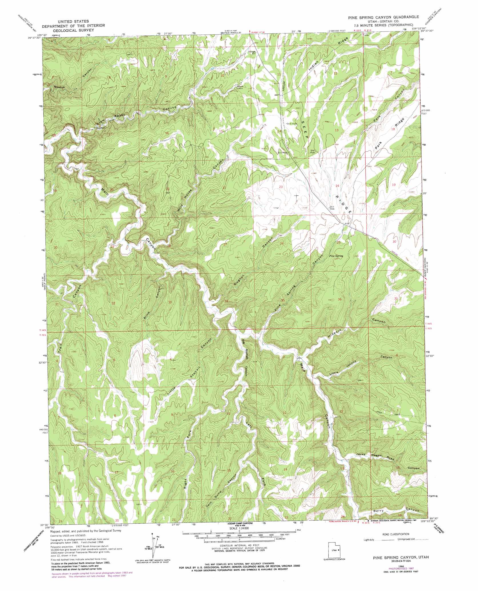
USGS Topo Quad 39109e4 - 1:24,000 scale
| Topo Map Name: | Pine Spring Canyon |
| USGS Topo Quad ID: | 39109e4 |
| Print Size: | ca. 21 1/4" wide x 27" high |
| Southeast Coordinates: | 39.5° N latitude / 109.375° W longitude |
| Map Center Coordinates: | 39.5625° N latitude / 109.4375° W longitude |
| U.S. State: | UT |
| Filename: | o39109e4.jpg |
| Download Map JPG Image: | Pine Spring Canyon topo map 1:24,000 scale |
| Map Type: | Topographic |
| Topo Series: | 7.5´ |
| Map Scale: | 1:24,000 |
| Source of Map Images: | United States Geological Survey (USGS) |
| Alternate Map Versions: |
Pine Spring Canyon UT 1966, updated 1984 Download PDF Buy paper map Pine Spring Canyon UT 1966, updated 1987 Download PDF Buy paper map Pine Spring Canyon UT 2011 Download PDF Buy paper map Pine Spring Canyon UT 2014 Download PDF Buy paper map |
1:24,000 Topo Quads surrounding Pine Spring Canyon
Big Pack Mountain |
Big Pack Mountain Se |
Buck Camp Canyon |
Archy Bench Se |
Rainbow |
Agency Draw Nw |
Agency Draw Ne |
Bates Knolls |
Cooper Canyon |
Burnt Timber Canyon |
Flat Rock Mesa |
Wolf Point |
Pine Spring Canyon |
Seep Canyon |
Tom Patterson Canyon |
Black Knolls |
Tenmile Canyon North |
Cedar Camp Canyon |
P R Spring |
San Arroyo Ridge |
Supply Canyon |
Tenmile Canyon South |
Preacher Canyon |
Dry Canyon |
Bryson Canyon |
> Back to 39109e1 at 1:100,000 scale
> Back to 39108a1 at 1:250,000 scale
> Back to U.S. Topo Maps home
Pine Spring Canyon topo map: Gazetteer
Pine Spring Canyon: Ridges
Seep Ridge elevation 2141m 7024′Pine Spring Canyon: Springs
Pine Spring elevation 2152m 7060′Pine Spring Canyon: Valleys
Berry Canyon elevation 2090m 6856′Big Asphalt Canyon elevation 2021m 6630′
Blind Canyon elevation 1975m 6479′
Crow Roost Canyon elevation 1879m 6164′
Dugout Canyon elevation 1999m 6558′
Hideout Canyon elevation 2042m 6699′
Jacks Wagon Road Canyon elevation 2072m 6797′
Left Fork Big Asphalt Canyon elevation 2044m 6706′
Little Asphalt Canyon elevation 2009m 6591′
Little Johnny Canyon elevation 2050m 6725′
Pine Spring Canyon elevation 2024m 6640′
Right Fork Big Asphalt Canyon elevation 2044m 6706′
Trail Canyon elevation 1946m 6384′
Twin Sump Canyon elevation 2115m 6938′
Wild Horse Canyon elevation 1959m 6427′
Pine Spring Canyon digital topo map on disk
Buy this Pine Spring Canyon topo map showing relief, roads, GPS coordinates and other geographical features, as a high-resolution digital map file on DVD: