Wolf Flat Topo Map Utah
To zoom in, hover over the map of Wolf Flat
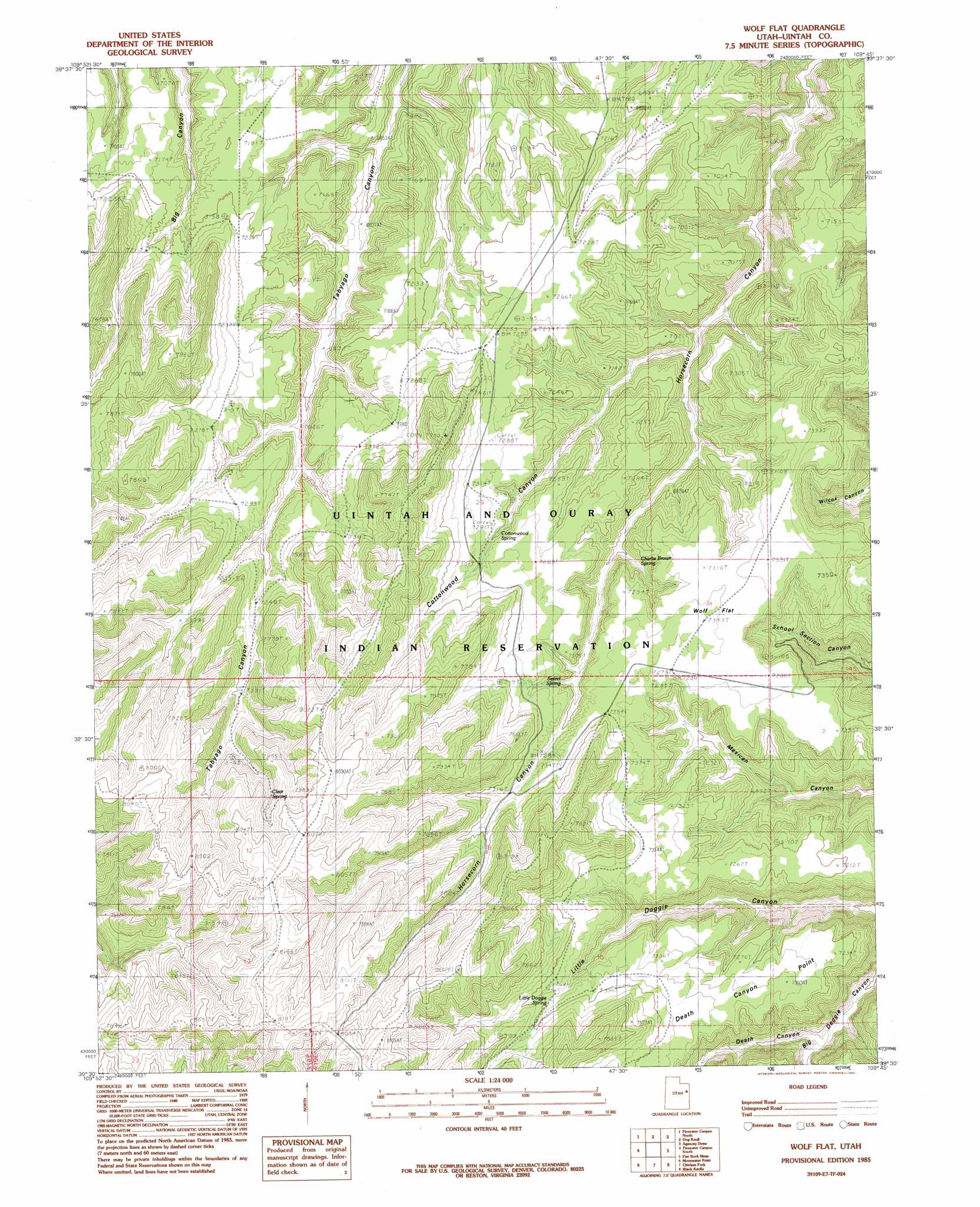
USGS Topo Quad 39109e7 - 1:24,000 scale
| Topo Map Name: | Wolf Flat |
| USGS Topo Quad ID: | 39109e7 |
| Print Size: | ca. 21 1/4" wide x 27" high |
| Southeast Coordinates: | 39.5° N latitude / 109.75° W longitude |
| Map Center Coordinates: | 39.5625° N latitude / 109.8125° W longitude |
| U.S. State: | UT |
| Filename: | o39109e7.jpg |
| Download Map JPG Image: | Wolf Flat topo map 1:24,000 scale |
| Map Type: | Topographic |
| Topo Series: | 7.5´ |
| Map Scale: | 1:24,000 |
| Source of Map Images: | United States Geological Survey (USGS) |
| Alternate Map Versions: |
Wolf Flat UT 1985, updated 1985 Download PDF Buy paper map Wolf Flat UT 2011 Download PDF Buy paper map Wolf Flat UT 2014 Download PDF Buy paper map |
1:24,000 Topo Quads surrounding Wolf Flat
Pinnacle Canyon |
Duches Hole |
Nutters Hole |
Big Pack Mountain |
Big Pack Mountain Se |
Cedar Ridge Canyon |
Firewater Canyon North |
Dog Knoll |
Agency Draw Nw |
Agency Draw Ne |
Steer Ridge Canyon |
Firewater Canyon South |
Wolf Flat |
Flat Rock Mesa |
Wolf Point |
Chandler Falls |
Moonwater Point |
Chicken Fork |
Black Knolls |
Tenmile Canyon North |
Three Fords Canyon |
Lion Canyon |
Walker Point |
Supply Canyon |
Tenmile Canyon South |
> Back to 39109e1 at 1:100,000 scale
> Back to 39108a1 at 1:250,000 scale
> Back to U.S. Topo Maps home
Wolf Flat topo map: Gazetteer
Wolf Flat: Cliffs
Death Canyon Point elevation 2303m 7555′Wolf Flat: Flats
Wolf Flat elevation 2233m 7326′Wolf Flat: Springs
Charlie Brown Spring elevation 2183m 7162′Clear Spring elevation 2353m 7719′
Cottonwood Spring elevation 2194m 7198′
Little Doggie Spring elevation 2239m 7345′
Secret Spring elevation 2182m 7158′
Wolf Flat: Valleys
Cottonwood Canyon elevation 1948m 6391′Death Canyon elevation 2043m 6702′
Wolf Flat digital topo map on disk
Buy this Wolf Flat topo map showing relief, roads, GPS coordinates and other geographical features, as a high-resolution digital map file on DVD: