Hadden Holes Topo Map Utah
To zoom in, hover over the map of Hadden Holes
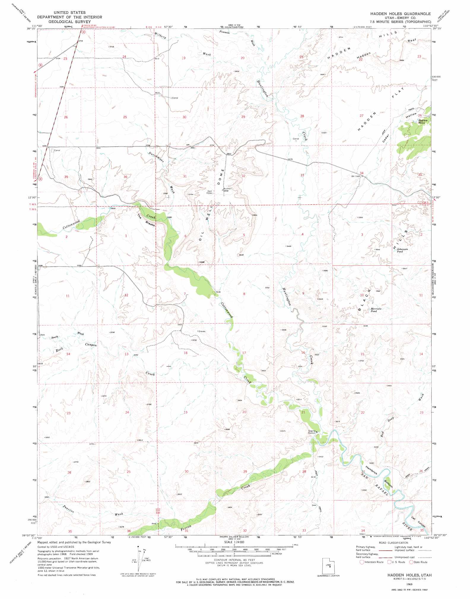
USGS Topo Quad 39110b8 - 1:24,000 scale
| Topo Map Name: | Hadden Holes |
| USGS Topo Quad ID: | 39110b8 |
| Print Size: | ca. 21 1/4" wide x 27" high |
| Southeast Coordinates: | 39.125° N latitude / 110.875° W longitude |
| Map Center Coordinates: | 39.1875° N latitude / 110.9375° W longitude |
| U.S. State: | UT |
| Filename: | o39110b8.jpg |
| Download Map JPG Image: | Hadden Holes topo map 1:24,000 scale |
| Map Type: | Topographic |
| Topo Series: | 7.5´ |
| Map Scale: | 1:24,000 |
| Source of Map Images: | United States Geological Survey (USGS) |
| Alternate Map Versions: |
Hadden Holes UT 1969, updated 1972 Download PDF Buy paper map Hadden Holes UT 2011 Download PDF Buy paper map Hadden Holes UT 2014 Download PDF Buy paper map |
1:24,000 Topo Quads surrounding Hadden Holes
Rilda Canyon |
Hiawatha |
Poison Spring Bench |
Elmo |
Olsen Reservoir |
Mahogany Point |
Red Point |
Huntington |
Cleveland |
Cow Flats |
The Cap |
Castle Dale |
Hadden Holes |
Buckhorn Reservoir |
Bob Hill Knoll |
Ferron |
Molen |
Horn Silver Gulch |
Sids Mountain |
Bottleneck Peak |
Emery East |
Short Canyon |
Sid And Charley |
The Blocks |
The Wickiup |
> Back to 39110a1 at 1:100,000 scale
> Back to 39110a1 at 1:250,000 scale
> Back to U.S. Topo Maps home
Hadden Holes topo map: Gazetteer
Hadden Holes: Bends
Hambrick Bottom elevation 1625m 5331′Hadden Holes: Cliffs
The Breaks elevation 1745m 5725′Hadden Holes: Flats
Hadden Flat elevation 1715m 5626′Hadden Holes: Lakes
Johansen Pond elevation 1717m 5633′Merrials Pond elevation 1710m 5610′
Hadden Holes: Springs
Hadden Holes elevation 1706m 5597′Hadden Holes: Streams
Cottonwood Creek elevation 1629m 5344′Ferron Creek elevation 1629m 5344′
Huntington Creek elevation 1629m 5344′
Rock Canyon Creek elevation 1646m 5400′
Hadden Holes: Summits
Black Hills elevation 1712m 5616′Oil Well Dome elevation 1785m 5856′
Hadden Holes: Trails
Gunnison Trail elevation 1708m 5603′Hadden Holes: Valleys
Cat Canyon elevation 1642m 5387′Cedar Hollow elevation 1659m 5442′
Dutchmans Wash elevation 1680m 5511′
Fivemile Wash elevation 1676m 5498′
Peavine Wash elevation 1669m 5475′
Red Seep Wash elevation 1622m 5321′
Rock Canyon elevation 1645m 5396′
South Wash elevation 1676m 5498′
Wilberg Wash elevation 1676m 5498′
Hadden Holes digital topo map on disk
Buy this Hadden Holes topo map showing relief, roads, GPS coordinates and other geographical features, as a high-resolution digital map file on DVD: