Deadman Canyon Topo Map Utah
To zoom in, hover over the map of Deadman Canyon
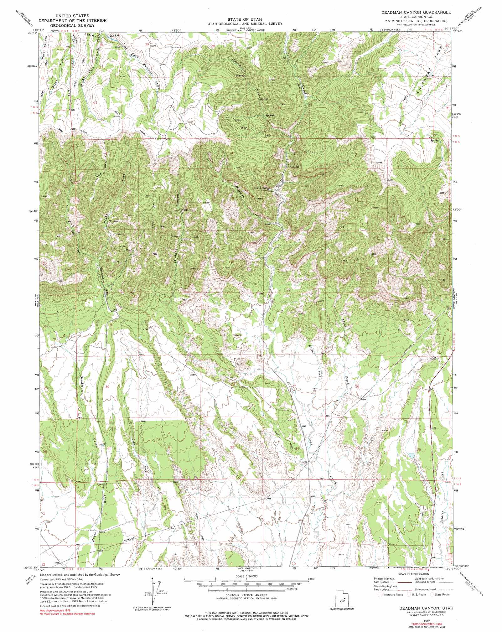
USGS Topo Quad 39110f6 - 1:24,000 scale
| Topo Map Name: | Deadman Canyon |
| USGS Topo Quad ID: | 39110f6 |
| Print Size: | ca. 21 1/4" wide x 27" high |
| Southeast Coordinates: | 39.625° N latitude / 110.625° W longitude |
| Map Center Coordinates: | 39.6875° N latitude / 110.6875° W longitude |
| U.S. State: | UT |
| Filename: | o39110f6.jpg |
| Download Map JPG Image: | Deadman Canyon topo map 1:24,000 scale |
| Map Type: | Topographic |
| Topo Series: | 7.5´ |
| Map Scale: | 1:24,000 |
| Source of Map Images: | United States Geological Survey (USGS) |
| Alternate Map Versions: |
Deadman Canyon UT 1972, updated 1976 Download PDF Buy paper map Deadman Canyon UT 1972, updated 1990 Download PDF Buy paper map Deadman Canyon UT 2011 Download PDF Buy paper map Deadman Canyon UT 2014 Download PDF Buy paper map |
1:24,000 Topo Quads surrounding Deadman Canyon
Flat Ridge |
Gray Head Peak |
Jones Hollow |
Lance Canyon |
Anthro Mountain |
Kyune |
Matts Summit |
Minnie Maud Creek West |
Minnie Maud Creek East |
Wood Canyon |
Standardville |
Helper |
Deadman Canyon |
Pine Canyon |
Mount Bartles |
Pinnacle Peak |
Price |
Wellington |
Sunnyside Junction |
Sunnyside |
Poison Spring Bench |
Elmo |
Olsen Reservoir |
Mounds |
Cedar |
> Back to 39110e1 at 1:100,000 scale
> Back to 39110a1 at 1:250,000 scale
> Back to U.S. Topo Maps home
Deadman Canyon topo map: Gazetteer
Deadman Canyon: Dams
E Andersons Dam elevation 1835m 6020′Deadman Canyon: Mines
Knight-Ideal Mine elevation 2056m 6745′Deadman Canyon: Reservoirs
Andersons Reservoir elevation 1835m 6020′Deadman Canyon: Streams
Alkali Creek elevation 1804m 5918′Bitter Creek elevation 1806m 5925′
Clearwater Creek elevation 2058m 6751′
Fish Creek elevation 1790m 5872′
Hoffman Creek elevation 1961m 6433′
Left Fork Antone Creek elevation 2463m 8080′
Left Fork Deadman Creek elevation 2090m 6856′
Right Fork Antone Creek elevation 2463m 8080′
Right Fork Deadman Creek elevation 2090m 6856′
Deadman Canyon: Valleys
Deadman Canyon elevation 1854m 6082′Straight Canyon elevation 1844m 6049′
Deadman Canyon digital topo map on disk
Buy this Deadman Canyon topo map showing relief, roads, GPS coordinates and other geographical features, as a high-resolution digital map file on DVD: