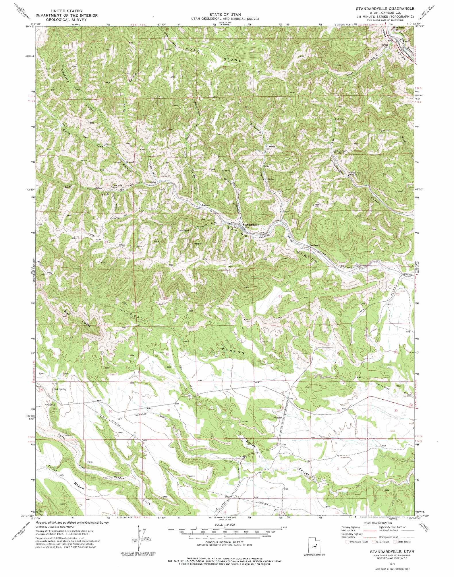
Standardville Topo Map Utah
To zoom in, hover over the map of Standardville
USGS Topo Quad 39110f8 - 1:24,000 scale
| Topo Map Name: | Standardville |
| USGS Topo Quad ID: | 39110f8 |
| Print Size: | ca. 21 1/4" wide x 27" high |
| Southeast Coordinates: | 39.625° N latitude / 110.875° W longitude |
| Map Center Coordinates: | 39.6875° N latitude / 110.9375° W longitude |
| U.S. State: | UT |
| Filename: | o39110f8.jpg |
| Download Map JPG Image: | Standardville topo map 1:24,000 scale |
| Map Type: | Topographic |
| Topo Series: | 7.5´ |
| Map Scale: | 1:24,000 |
| Source of Map Images: | United States Geological Survey (USGS) |
| Alternate Map Versions: |
Standardville UT 1972, updated 1976 Download PDF Buy paper map Standardville UT 2011 Download PDF Buy paper map Standardville UT 2014 Download PDF Buy paper map |
1:24,000 Topo Quads surrounding Standardville
Tucker |
Soldier Summit |
Flat Ridge |
Gray Head Peak |
Jones Hollow |
Scofield Reservoir |
Colton |
Kyune |
Matts Summit |
Minnie Maud Creek West |
Scofield |
Jump Creek |
Standardville |
Helper |
Deadman Canyon |
Candland Mountain |
Wattis |
Pinnacle Peak |
Price |
Wellington |
Rilda Canyon |
Hiawatha |
Poison Spring Bench |
Elmo |
Olsen Reservoir |
> Back to 39110e1 at 1:100,000 scale
> Back to 39110a1 at 1:250,000 scale
> Back to U.S. Topo Maps home
Standardville topo map: Gazetteer
Standardville: Benches
Cedar Bench elevation 2110m 6922′Standardville: Cliffs
Bull Point elevation 2206m 7237′Standardville: Gaps
The Castle Gate elevation 1920m 6299′Standardville: Mines
Carbon Fuel Mine Number 2 elevation 2081m 6827′Carbon Fuel Mine Number 3 elevation 2062m 6765′
Lone Pine Mine elevation 2260m 7414′
Peerless Mine elevation 2179m 7148′
Rolapp Mine elevation 1932m 6338′
Standardville: Populated Places
Latuda elevation 2091m 6860′Peerless elevation 1965m 6446′
Royal elevation 1899m 6230′
Standardville elevation 2054m 6738′
Storrs elevation 2022m 6633′
Wildcat elevation 1885m 6184′
Standardville: Springs
Oak Spring elevation 2065m 6774′Standardville: Streams
Twin Washes elevation 1773m 5816′Standardville: Valleys
Bear Canyon elevation 1918m 6292′Burnt Tree Fork elevation 2174m 7132′
Ciochetto Canyon elevation 2247m 7372′
Gilson Gulch elevation 2059m 6755′
Left Fork Spring Canyon elevation 2174m 7132′
Rains Canyon elevation 2167m 7109′
Robinson Gulch elevation 2094m 6870′
Sowbelly Gulch elevation 1991m 6532′
Wildcat Canyon elevation 1866m 6122′
Standardville digital topo map on disk
Buy this Standardville topo map showing relief, roads, GPS coordinates and other geographical features, as a high-resolution digital map file on DVD: