Wattis Topo Map Utah
To zoom in, hover over the map of Wattis
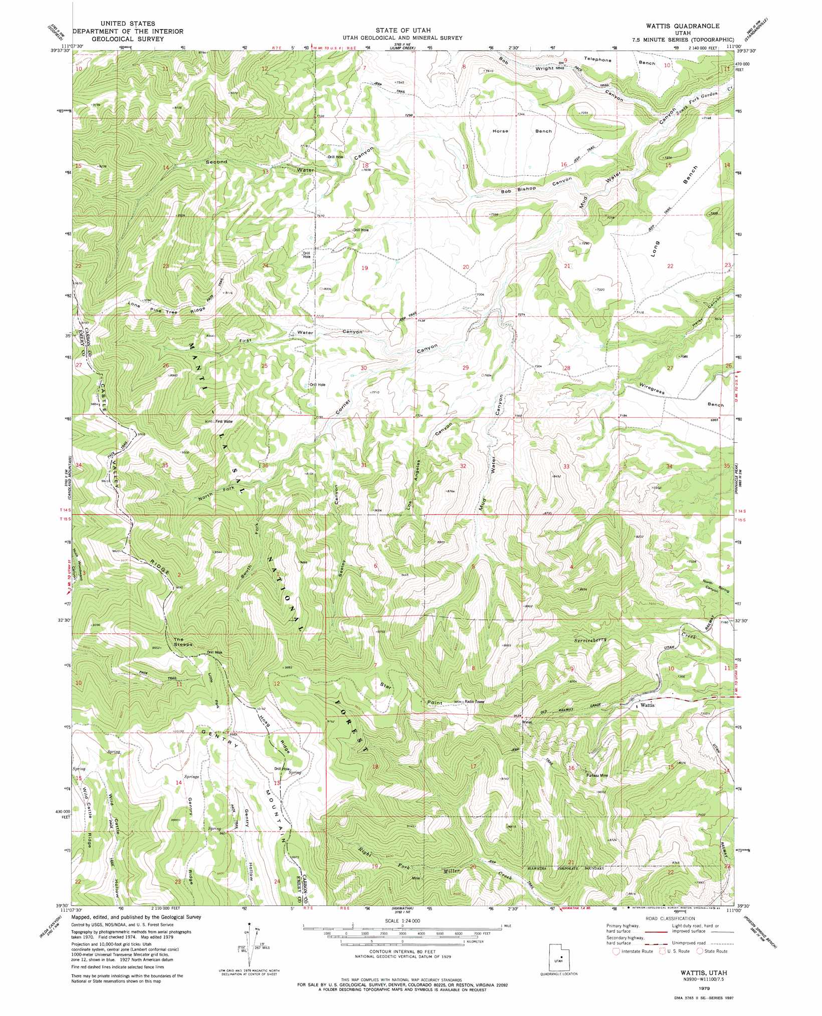
USGS Topo Quad 39111e1 - 1:24,000 scale
| Topo Map Name: | Wattis |
| USGS Topo Quad ID: | 39111e1 |
| Print Size: | ca. 21 1/4" wide x 27" high |
| Southeast Coordinates: | 39.5° N latitude / 111° W longitude |
| Map Center Coordinates: | 39.5625° N latitude / 111.0625° W longitude |
| U.S. State: | UT |
| Filename: | o39111e1.jpg |
| Download Map JPG Image: | Wattis topo map 1:24,000 scale |
| Map Type: | Topographic |
| Topo Series: | 7.5´ |
| Map Scale: | 1:24,000 |
| Source of Map Images: | United States Geological Survey (USGS) |
| Alternate Map Versions: |
Wattis UT 1979, updated 1983 Download PDF Buy paper map Wattis UT 2001, updated 2004 Download PDF Buy paper map Wattis UT 2011 Download PDF Buy paper map Wattis UT 2014 Download PDF Buy paper map |
| FStopo: | US Forest Service topo Wattis is available: Download FStopo PDF Download FStopo TIF |
1:24,000 Topo Quads surrounding Wattis
C Canyon |
Scofield Reservoir |
Colton |
Kyune |
Matts Summit |
Fairview Lakes |
Scofield |
Jump Creek |
Standardville |
Helper |
Huntington Reservoir |
Candland Mountain |
Wattis |
Pinnacle Peak |
Price |
South Tent Mountain |
Rilda Canyon |
Hiawatha |
Poison Spring Bench |
Elmo |
Joes Valley Reservoir |
Mahogany Point |
Red Point |
Huntington |
Cleveland |
> Back to 39111e1 at 1:100,000 scale
> Back to 39110a1 at 1:250,000 scale
> Back to U.S. Topo Maps home
Wattis topo map: Gazetteer
Wattis: Benches
Horse Bench elevation 2235m 7332′Long Bench elevation 2156m 7073′
Wiregrass Bench elevation 2138m 7014′
Wattis: Cliffs
The Steeps elevation 2977m 9767′Wattis: Flats
Little Park elevation 2961m 9714′Wattis: Mines
Plateau Mine elevation 2572m 8438′Star Point Mine elevation 2625m 8612′
Wattis: Populated Places
Wattis elevation 2273m 7457′Wattis: Ridges
Castle Valley Ridge elevation 2912m 9553′Gentry Ridge elevation 3035m 9957′
Hoag Ridge elevation 3091m 10141′
Lone Pine Tree Ridge elevation 2800m 9186′
Wild Cattle Ridge elevation 2908m 9540′
Wattis: Summits
Gentry Mountain elevation 3082m 10111′Star Point elevation 2926m 9599′
Wattis: Valleys
Bob Bishop Canyon elevation 2073m 6801′Bob Wright Canyon elevation 2014m 6607′
Corner Canyon elevation 2164m 7099′
First Water Canyon elevation 2228m 7309′
Los Angeles Canyon elevation 2253m 7391′
Mud Water Canyon elevation 2014m 6607′
North Fork Corner Canyon elevation 2379m 7805′
Second Water Canyon elevation 2174m 7132′
Seeley Canyon elevation 2292m 7519′
South Fork Corner Canyon elevation 2379m 7805′
Wattis digital topo map on disk
Buy this Wattis topo map showing relief, roads, GPS coordinates and other geographical features, as a high-resolution digital map file on DVD: