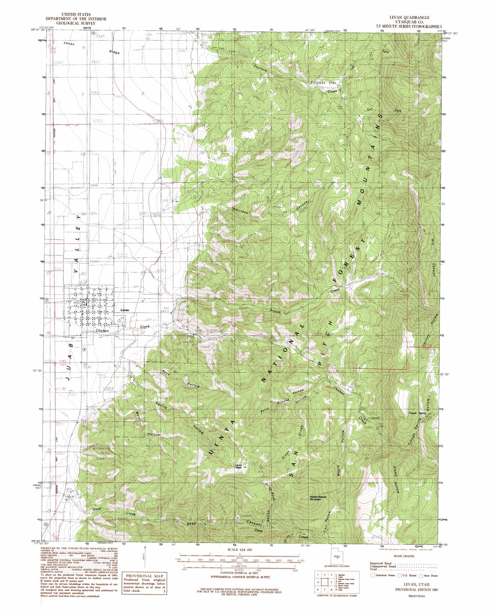
Levan Topo Map Utah
To zoom in, hover over the map of Levan
USGS Topo Quad 39111e7 - 1:24,000 scale
| Topo Map Name: | Levan |
| USGS Topo Quad ID: | 39111e7 |
| Print Size: | ca. 21 1/4" wide x 27" high |
| Southeast Coordinates: | 39.5° N latitude / 111.75° W longitude |
| Map Center Coordinates: | 39.5625° N latitude / 111.8125° W longitude |
| U.S. State: | UT |
| Filename: | o39111e7.jpg |
| Download Map JPG Image: | Levan topo map 1:24,000 scale |
| Map Type: | Topographic |
| Topo Series: | 7.5´ |
| Map Scale: | 1:24,000 |
| Source of Map Images: | United States Geological Survey (USGS) |
| Alternate Map Versions: |
Levan UT 1983, updated 1983 Download PDF Buy paper map Levan UT 2001, updated 2004 Download PDF Buy paper map Levan UT 2011 Download PDF Buy paper map Levan UT 2014 Download PDF Buy paper map |
| FStopo: | US Forest Service topo Levan is available: Download FStopo PDF Download FStopo TIF |
1:24,000 Topo Quads surrounding Levan
Tintic Mountain |
Slate Jack Canyon |
Mona |
Nebo Basin |
Spencer Canyon |
Furner Ridge |
Sugarloaf |
Nephi |
Fountain Green North |
Big Hollow |
Sage Valley |
Juab |
Levan |
Fountain Green South |
Moroni |
Mills |
Skinner Peaks |
Chriss Canyon |
Wales |
Chester |
Scipio North |
Hells Kitchen Canyon Sw |
Hells Kitchen Canyon Se |
Manti |
Ephraim |
> Back to 39111e1 at 1:100,000 scale
> Back to 39110a1 at 1:250,000 scale
> Back to U.S. Topo Maps home
Levan topo map: Gazetteer
Levan: Flats
Coleman Flat elevation 1877m 6158′Levan: Parks
Deep Creek Wildlife Management Area elevation 1724m 5656′Levan Wildlife Management Area elevation 1834m 6017′
Levan: Populated Places
Levan elevation 1620m 5314′Levan: Slopes
Levan Ridge elevation 1642m 5387′Levan: Springs
Trough Spring elevation 2260m 7414′Levan: Streams
Chicken Creek elevation 1608m 5275′Deep Creek elevation 1646m 5400′
Dry Fork elevation 1945m 6381′
Left Fork Fourmile Creek elevation 1892m 6207′
Pigeon Creek elevation 1677m 5501′
Right Fork Deep Creek elevation 2079m 6820′
Levan: Summits
Horse Heaven Mountain elevation 2541m 8336′Levan Peak elevation 2540m 8333′
Levan: Valleys
Burnt Ground Hollow elevation 1833m 6013′Chicken Hollow elevation 1677m 5501′
Deep Canyon elevation 1687m 5534′
Dry Canyon elevation 2077m 6814′
Green Grove Hollow elevation 1791m 5875′
Hartleys Canyon elevation 1686m 5531′
Maple Hollow elevation 1847m 6059′
Rock Hollow elevation 1646m 5400′
Slide Rock Hollow elevation 2009m 6591′
Spring Hollow elevation 1701m 5580′
Stump Hollow elevation 2014m 6607′
Trail Hollow elevation 2099m 6886′
Trough Spring Hollow elevation 2029m 6656′
Water Hollow elevation 1691m 5547′
Levan digital topo map on disk
Buy this Levan topo map showing relief, roads, GPS coordinates and other geographical features, as a high-resolution digital map file on DVD: