Fairview Topo Map Utah
To zoom in, hover over the map of Fairview
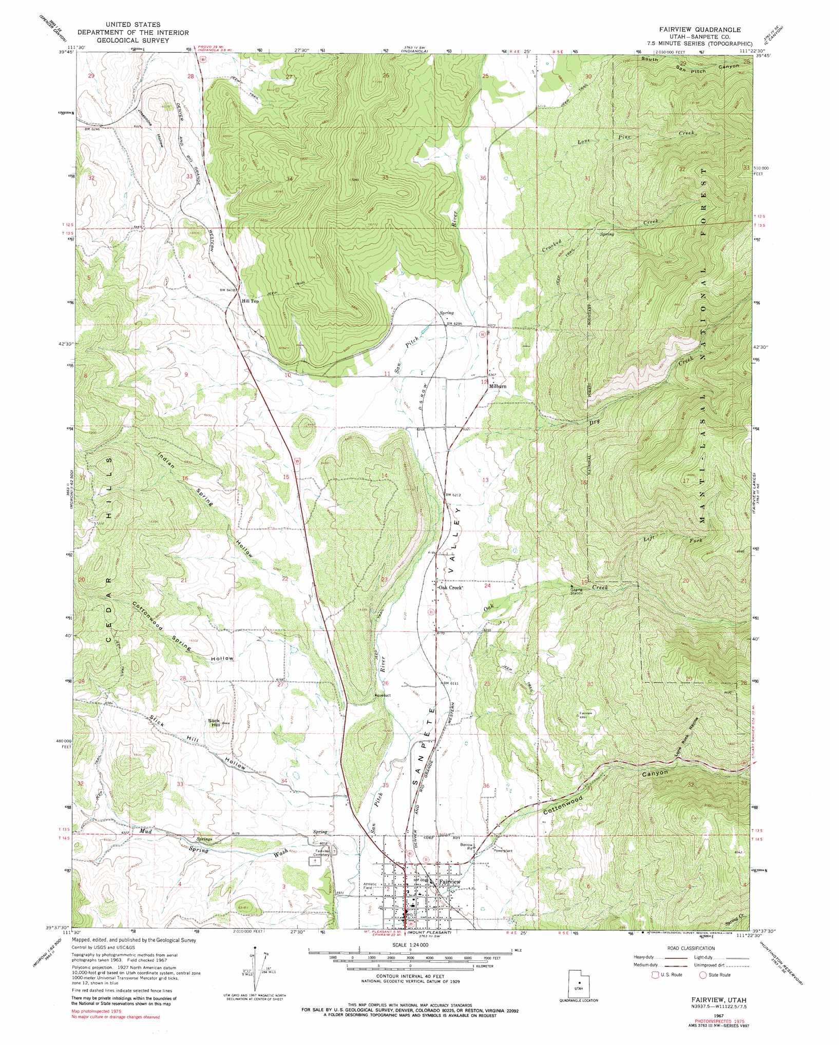
USGS Topo Quad 39111f4 - 1:24,000 scale
| Topo Map Name: | Fairview |
| USGS Topo Quad ID: | 39111f4 |
| Print Size: | ca. 21 1/4" wide x 27" high |
| Southeast Coordinates: | 39.625° N latitude / 111.375° W longitude |
| Map Center Coordinates: | 39.6875° N latitude / 111.4375° W longitude |
| U.S. State: | UT |
| Filename: | o39111f4.jpg |
| Download Map JPG Image: | Fairview topo map 1:24,000 scale |
| Map Type: | Topographic |
| Topo Series: | 7.5´ |
| Map Scale: | 1:24,000 |
| Source of Map Images: | United States Geological Survey (USGS) |
| Alternate Map Versions: |
Fairview UT 1967, updated 1969 Download PDF Buy paper map Fairview UT 2001, updated 2004 Download PDF Buy paper map Fairview UT 2011 Download PDF Buy paper map Fairview UT 2014 Download PDF Buy paper map |
| FStopo: | US Forest Service topo Fairview is available: Download FStopo PDF Download FStopo TIF |
1:24,000 Topo Quads surrounding Fairview
Payson Lakes |
Birdseye |
Thistle |
Mill Fork |
Tucker |
Nebo Basin |
Spencer Canyon |
Indianola |
C Canyon |
Scofield Reservoir |
Fountain Green North |
Big Hollow |
Fairview |
Fairview Lakes |
Scofield |
Fountain Green South |
Moroni |
Mount Pleasant |
Huntington Reservoir |
Candland Mountain |
Wales |
Chester |
Spring City |
South Tent Mountain |
Rilda Canyon |
> Back to 39111e1 at 1:100,000 scale
> Back to 39110a1 at 1:250,000 scale
> Back to U.S. Topo Maps home
Fairview topo map: Gazetteer
Fairview: Parks
Hilltop Wildlife Management Area elevation 1993m 6538′Fairview: Populated Places
Fairview elevation 1813m 5948′Hill Top elevation 1964m 6443′
Milburn elevation 1940m 6364′
Oak Creek elevation 1884m 6181′
Fairview: Post Offices
Fairview Post Office elevation 1816m 5958′Fairview: Streams
Crooked Creek elevation 1940m 6364′Dry Creek elevation 1897m 6223′
Left Fork Oak Creek elevation 2053m 6735′
Lone Pine Creek elevation 2009m 6591′
Maple Fork elevation 2146m 7040′
Oak Creek elevation 1847m 6059′
Fairview: Summits
Cedar Hills elevation 1996m 6548′Slick Hill elevation 1960m 6430′
Fairview: Valleys
Cottonwood Spring Hollow elevation 1877m 6158′Fairview Canyon elevation 1886m 6187′
Indian Spring Hollow elevation 1880m 6167′
Josephine Hollow elevation 1903m 6243′
Lone Rock Ravine elevation 2089m 6853′
Mud Spring Wash elevation 1823m 5980′
North Fork Mud Spring Wash elevation 1914m 6279′
Slick Hill Hollow elevation 1828m 5997′
Fairview digital topo map on disk
Buy this Fairview topo map showing relief, roads, GPS coordinates and other geographical features, as a high-resolution digital map file on DVD: