Payson Lakes Topo Map Utah
To zoom in, hover over the map of Payson Lakes
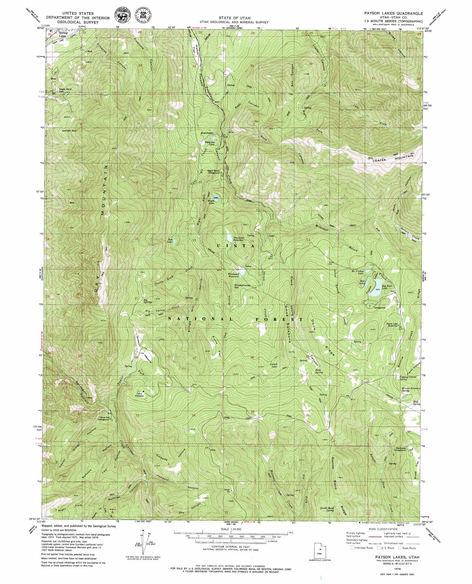
USGS Topo Quad 39111h6 - 1:24,000 scale
| Topo Map Name: | Payson Lakes |
| USGS Topo Quad ID: | 39111h6 |
| Print Size: | ca. 21 1/4" wide x 27" high |
| Southeast Coordinates: | 39.875° N latitude / 111.625° W longitude |
| Map Center Coordinates: | 39.9375° N latitude / 111.6875° W longitude |
| U.S. State: | UT |
| Filename: | o39111h6.jpg |
| Download Map JPG Image: | Payson Lakes topo map 1:24,000 scale |
| Map Type: | Topographic |
| Topo Series: | 7.5´ |
| Map Scale: | 1:24,000 |
| Source of Map Images: | United States Geological Survey (USGS) |
| Alternate Map Versions: |
Payson Lakes UT 1979, updated 1979 Download PDF Buy paper map Payson Lakes UT 1998, updated 2002 Download PDF Buy paper map Payson Lakes UT 2011 Download PDF Buy paper map Payson Lakes UT 2014 Download PDF Buy paper map |
| FStopo: | US Forest Service topo Payson Lakes is available: Download FStopo PDF Download FStopo TIF |
1:24,000 Topo Quads surrounding Payson Lakes
Soldiers Pass |
Lincoln Point |
Provo |
Springville |
Granger Mountain |
Goshen Valley North |
West Mountain |
Spanish Fork |
Spanish Fork Peak |
Billies Mountain |
Goshen |
Santaquin |
Payson Lakes |
Birdseye |
Thistle |
Slate Jack Canyon |
Mona |
Nebo Basin |
Spencer Canyon |
Indianola |
Sugarloaf |
Nephi |
Fountain Green North |
Big Hollow |
Fairview |
> Back to 39111e1 at 1:100,000 scale
> Back to 39110a1 at 1:250,000 scale
> Back to U.S. Topo Maps home
Payson Lakes topo map: Gazetteer
Payson Lakes: Dams
Big East Dam elevation 2401m 7877′Dry Lake Dam elevation 2154m 7066′
Maple Lake Dam elevation 1952m 6404′
McClellan Lake Dam elevation 2347m 7700′
Pete Winward Dam elevation 2140m 7020′
Payson Lakes: Flats
Kuntz Flat elevation 2391m 7844′Santaquin Meadows elevation 2371m 7778′
Soap Flat elevation 2397m 7864′
Tinney Flat elevation 2147m 7043′
Walker Flat elevation 1569m 5147′
Payson Lakes: Lakes
Box Lake elevation 2385m 7824′Lizard Lake elevation 2416m 7926′
Payson Lakes elevation 2401m 7877′
Red Lake elevation 2125m 6971′
Payson Lakes: Mines
Golden Relief Mine elevation 1713m 5620′Syndicate Mine elevation 2142m 7027′
Payson Lakes: Reservoirs
Big East Reservoir elevation 2401m 7877′Dry Lake Reservoir elevation 2159m 7083′
Maple Lake elevation 1952m 6404′
McClellan Lake elevation 2347m 7700′
Pete Winward Reservoir elevation 2140m 7020′
Payson Lakes: Ridges
Amos Backbone elevation 2408m 7900′Bennie Creek Ridge elevation 2485m 8152′
Done Ridge elevation 2521m 8270′
Gentle Band Ridge elevation 2564m 8412′
Payson Lakes: Springs
Big Springs elevation 2410m 7906′Dipping Corral Spring elevation 2485m 8152′
Gentle Band Spring elevation 2479m 8133′
Minnie Simmons Spring elevation 2489m 8166′
Mud Spring elevation 2439m 8001′
Rock Spring elevation 2463m 8080′
Payson Lakes: Streams
Big Spring Creek elevation 2009m 6591′Castle Rock Creek elevation 2014m 6607′
Coal Pit Creek elevation 1698m 5570′
Jones Ranch Creek elevation 2197m 7208′
Right Fork Peteeneet Creek elevation 1742m 5715′
Shram Creek elevation 2007m 6584′
Taylor Fork elevation 2104m 6902′
Tie Fork elevation 2180m 7152′
Wimmer Ranch Creek elevation 1918m 6292′
Payson Lakes: Summits
Dry Mountain elevation 2999m 9839′Sheepherder Hill elevation 2168m 7112′
Payson Lakes: Valleys
Bear Canyon elevation 1717m 5633′Bellows Hollow elevation 2183m 7162′
Box Canyon elevation 1908m 6259′
Calkens Hollow elevation 2233m 7326′
Crooked Canyon elevation 1489m 4885′
Dry Hollow elevation 2355m 7726′
Frank Young Canyon elevation 1996m 6548′
Jumpoff Hollow elevation 2248m 7375′
Left Fork Loafer Canyon elevation 1935m 6348′
Left Fork Sullivan Canyon elevation 2421m 7942′
Levi Hollow elevation 2216m 7270′
Lower Water Hollow elevation 2128m 6981′
Middle Fork Sullivan Canyon elevation 2424m 7952′
Mud Hollow elevation 2278m 7473′
Right Fork Loafer Canyon elevation 1935m 6348′
Right Fork Sullivan Canyon elevation 2421m 7942′
Rock Canyon elevation 1731m 5679′
Shingle Mill Hollow elevation 2009m 6591′
Sullivan Canyon elevation 2264m 7427′
The Gulch elevation 2091m 6860′
Payson Lakes digital topo map on disk
Buy this Payson Lakes topo map showing relief, roads, GPS coordinates and other geographical features, as a high-resolution digital map file on DVD: