Coffee Peak Topo Map Utah
To zoom in, hover over the map of Coffee Peak
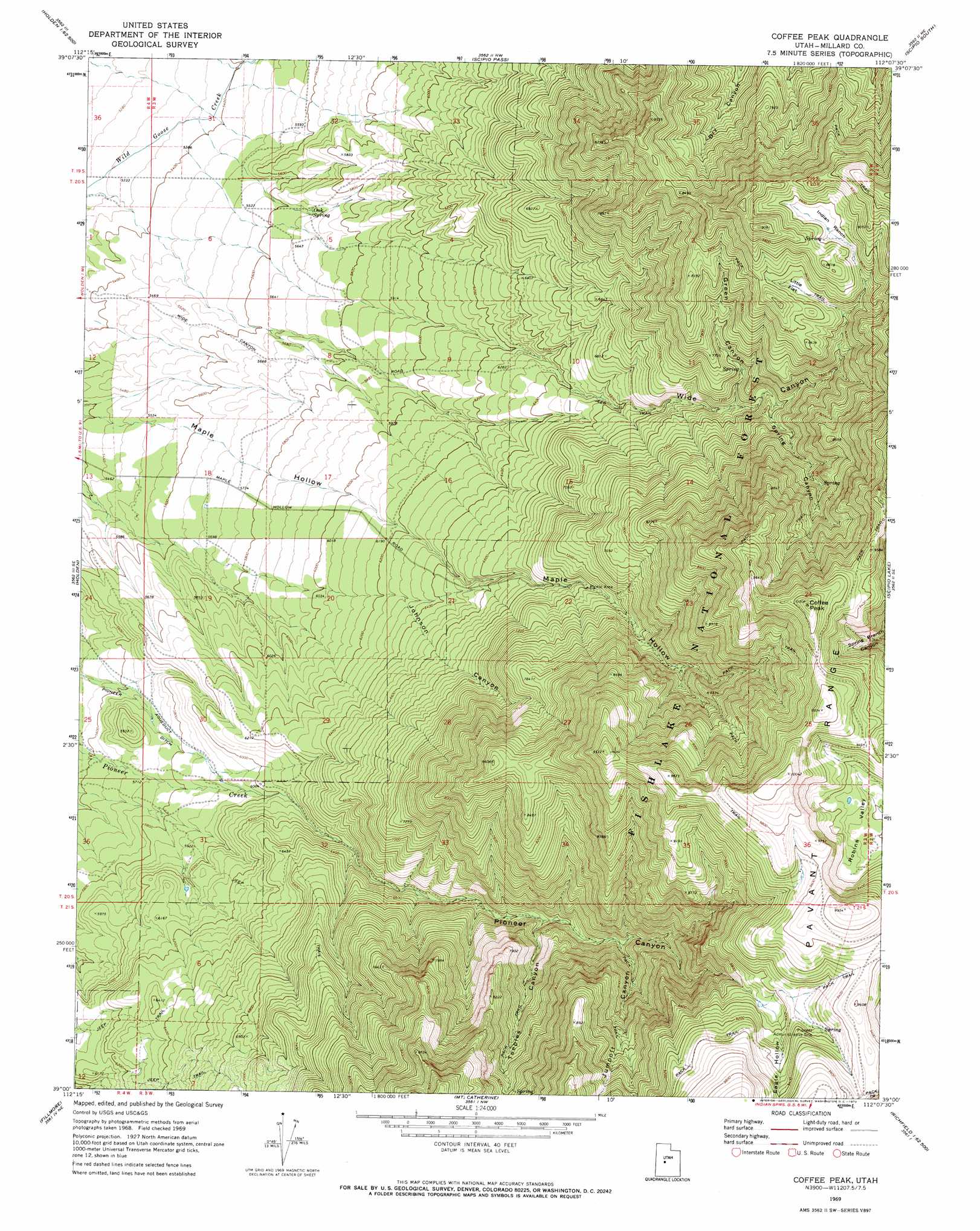
USGS Topo Quad 39112a2 - 1:24,000 scale
| Topo Map Name: | Coffee Peak |
| USGS Topo Quad ID: | 39112a2 |
| Print Size: | ca. 21 1/4" wide x 27" high |
| Southeast Coordinates: | 39° N latitude / 112.125° W longitude |
| Map Center Coordinates: | 39.0625° N latitude / 112.1875° W longitude |
| U.S. State: | UT |
| Filename: | o39112a2.jpg |
| Download Map JPG Image: | Coffee Peak topo map 1:24,000 scale |
| Map Type: | Topographic |
| Topo Series: | 7.5´ |
| Map Scale: | 1:24,000 |
| Source of Map Images: | United States Geological Survey (USGS) |
| Alternate Map Versions: |
Coffee Peak UT 1969, updated 1972 Download PDF Buy paper map Coffee Peak UT 2001, updated 2003 Download PDF Buy paper map Coffee Peak UT 2011 Download PDF Buy paper map Coffee Peak UT 2014 Download PDF Buy paper map |
| FStopo: | US Forest Service topo Coffee Peak is available: Download FStopo PDF Download FStopo TIF |
1:24,000 Topo Quads surrounding Coffee Peak
Harding |
Oak City South |
Williams Peak |
Scipio North |
Hells Kitchen Canyon Sw |
Mccornick |
Duggins Creek |
Scipio Pass |
Scipio South |
Hayes Canyon |
The Sink |
Holden |
Coffee Peak |
Scipio Lake |
Redmond Canyon |
Meadow |
Fillmore |
Mount Catherine |
Beehive Peak |
Aurora |
Kanosh |
Sunset Peak |
White Pine Peak |
Richfield |
Sigurd |
> Back to 39112a1 at 1:100,000 scale
> Back to 39112a1 at 1:250,000 scale
> Back to U.S. Topo Maps home
Coffee Peak topo map: Gazetteer
Coffee Peak: Basins
Robins Valley elevation 2745m 9005′Coffee Peak: Flats
Indian Ranch elevation 2604m 8543′Little Flat elevation 2531m 8303′
Coffee Peak: Parks
Maple Hollow Picnic Area elevation 2139m 7017′Nixon Wildlife Management Area elevation 1812m 5944′
Pioneer Wildlife Management Area elevation 1856m 6089′
Coffee Peak: Springs
Bennett Spring elevation 2148m 7047′Indian Spring elevation 2612m 8569′
Oak Spring elevation 1727m 5666′
Wide Mouth Spring elevation 2233m 7326′
Coffee Peak: Summits
Coffee Peak elevation 3038m 9967′Coffee Peak: Valleys
Eagle Hollow elevation 2712m 8897′Green Canyon elevation 2171m 7122′
Johnson Canyon elevation 1710m 5610′
Jumpoff Canyon elevation 2263m 7424′
Pioneer Canyon elevation 1955m 6414′
Spring Canyon elevation 2261m 7417′
Teeples Canyon elevation 2144m 7034′
Wide Canyon elevation 1980m 6496′
Coffee Peak digital topo map on disk
Buy this Coffee Peak topo map showing relief, roads, GPS coordinates and other geographical features, as a high-resolution digital map file on DVD: