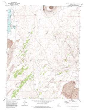
Pavant Butte South Topo Map Utah
To zoom in, hover over the map of Pavant Butte South
USGS Topo Quad 39112a5 - 1:24,000 scale
| Topo Map Name: | Pavant Butte South |
| USGS Topo Quad ID: | 39112a5 |
| Print Size: | ca. 21 1/4" wide x 27" high |
| Southeast Coordinates: | 39° N latitude / 112.5° W longitude |
| Map Center Coordinates: | 39.0625° N latitude / 112.5625° W longitude |
| U.S. State: | UT |
| Filename: | o39112a5.jpg |
| Download Map JPG Image: | Pavant Butte South topo map 1:24,000 scale |
| Map Type: | Topographic |
| Topo Series: | 7.5´ |
| Map Scale: | 1:24,000 |
| Source of Map Images: | United States Geological Survey (USGS) |
| Alternate Map Versions: |
Pavant Butte South UT 1971, updated 1974 Download PDF Buy paper map Pahvant Butte South UT 1971, updated 1988 Download PDF Buy paper map Pahvant Butte South UT 2011 Download PDF Buy paper map Pahvant Butte South UT 2014 Download PDF Buy paper map |
1:24,000 Topo Quads surrounding Pavant Butte South
> Back to 39112a1 at 1:100,000 scale
> Back to 39112a1 at 1:250,000 scale
> Back to U.S. Topo Maps home
Pavant Butte South topo map: Gazetteer
Pavant Butte South: Basins
Devils Kitchen elevation 1409m 4622′Hellhole elevation 1473m 4832′
Pavant Butte South: Lakes
Clear Lake elevation 1399m 4589′Pavant Butte South: Reservoirs
Devils Kitchen Reservoir elevation 1409m 4622′Spring Lake elevation 1401m 4596′
Pavant Butte South: Wells
North Pool Well elevation 1418m 4652′Pavant Butte South digital topo map on disk
Buy this Pavant Butte South topo map showing relief, roads, GPS coordinates and other geographical features, as a high-resolution digital map file on DVD:


