Notch Peak Topo Map Utah
To zoom in, hover over the map of Notch Peak
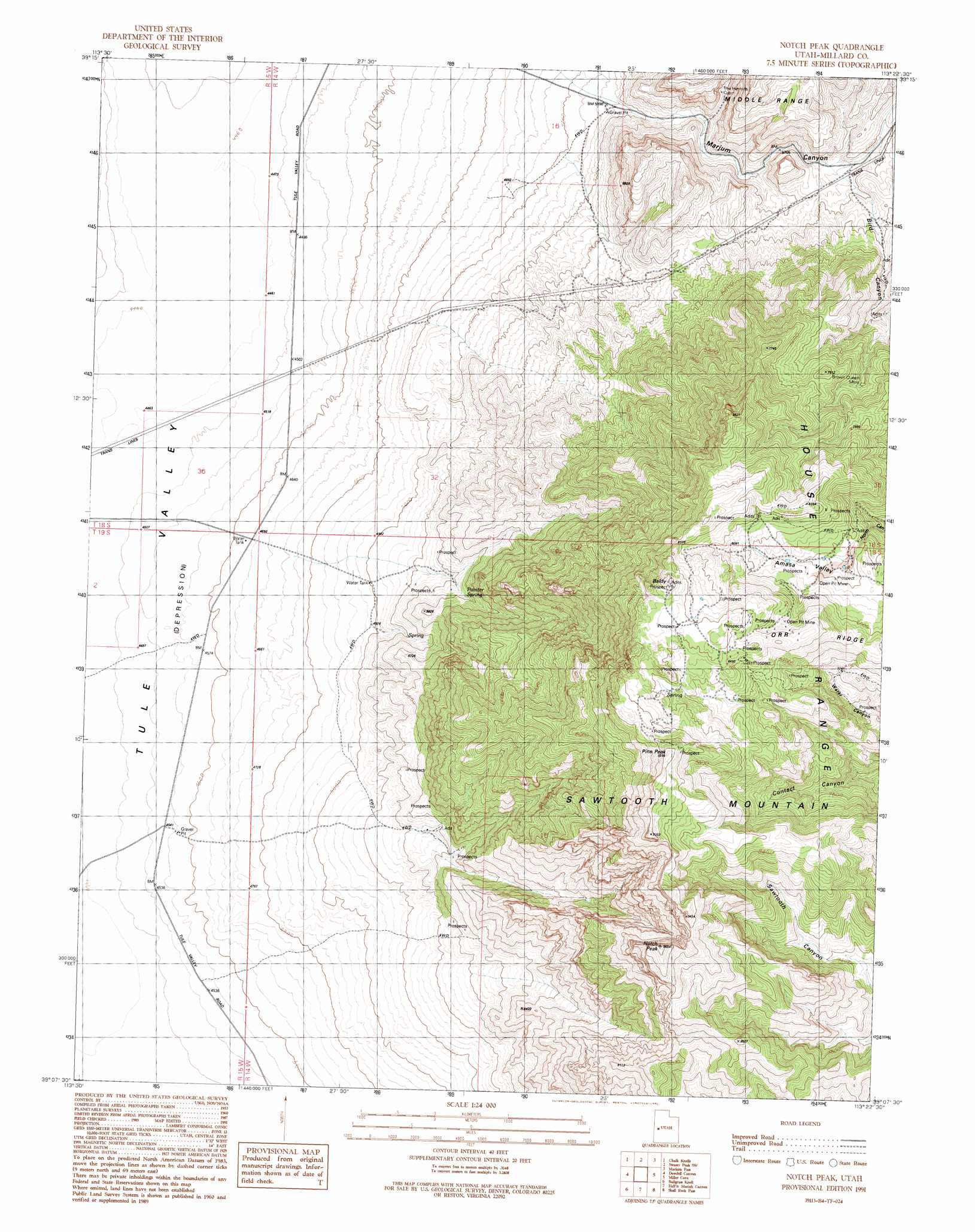
USGS Topo Quad 39113b4 - 1:24,000 scale
| Topo Map Name: | Notch Peak |
| USGS Topo Quad ID: | 39113b4 |
| Print Size: | ca. 21 1/4" wide x 27" high |
| Southeast Coordinates: | 39.125° N latitude / 113.375° W longitude |
| Map Center Coordinates: | 39.1875° N latitude / 113.4375° W longitude |
| U.S. State: | UT |
| Filename: | o39113b4.jpg |
| Download Map JPG Image: | Notch Peak topo map 1:24,000 scale |
| Map Type: | Topographic |
| Topo Series: | 7.5´ |
| Map Scale: | 1:24,000 |
| Source of Map Images: | United States Geological Survey (USGS) |
| Alternate Map Versions: |
Notch Peak UT 1991, updated 1991 Download PDF Buy paper map Notch Peak UT 2011 Download PDF Buy paper map Notch Peak UT 2014 Download PDF Buy paper map |
1:24,000 Topo Quads surrounding Notch Peak
Big Horseshoe |
Coyote Knolls |
Swasey Peak Nw |
Swasey Peak |
Whirlwind Valley Nw |
Cowboy Pass |
Chalk Knolls |
Swasey Peak Sw |
Marjum Pass |
Whirlwind Valley Sw |
Conger Mountain |
Dowdell Canyon |
Notch Peak |
Miller Cove |
Long Ridge Reservoir |
Thompson Knoll |
Bullgrass Knoll |
Hell'N Maria Canyon |
Skull Rock Pass |
Long Ridge Sw |
Pyramid Knoll |
King Top |
The Barn |
Burnout Canyon |
Needle Point |
> Back to 39113a1 at 1:100,000 scale
> Back to 39112a1 at 1:250,000 scale
> Back to U.S. Topo Maps home
Notch Peak topo map: Gazetteer
Notch Peak: Mines
Brown Queen Mine elevation 2140m 7020′Notch Peak: Ranges
House Range elevation 2070m 6791′Notch Peak: Springs
Painter Spring elevation 1680m 5511′Notch Peak: Summits
Antelope Mountain elevation 2032m 6666′Baldy elevation 2557m 8389′
Notch Peak elevation 2833m 9294′
Pine Peak elevation 2811m 9222′
Sawtooth Mountain elevation 2587m 8487′
Notch Peak: Valleys
Bird Canyon elevation 1808m 5931′Marjum Canyon elevation 1562m 5124′
Notch Peak digital topo map on disk
Buy this Notch Peak topo map showing relief, roads, GPS coordinates and other geographical features, as a high-resolution digital map file on DVD: