Lehman Caves Topo Map Nevada
To zoom in, hover over the map of Lehman Caves
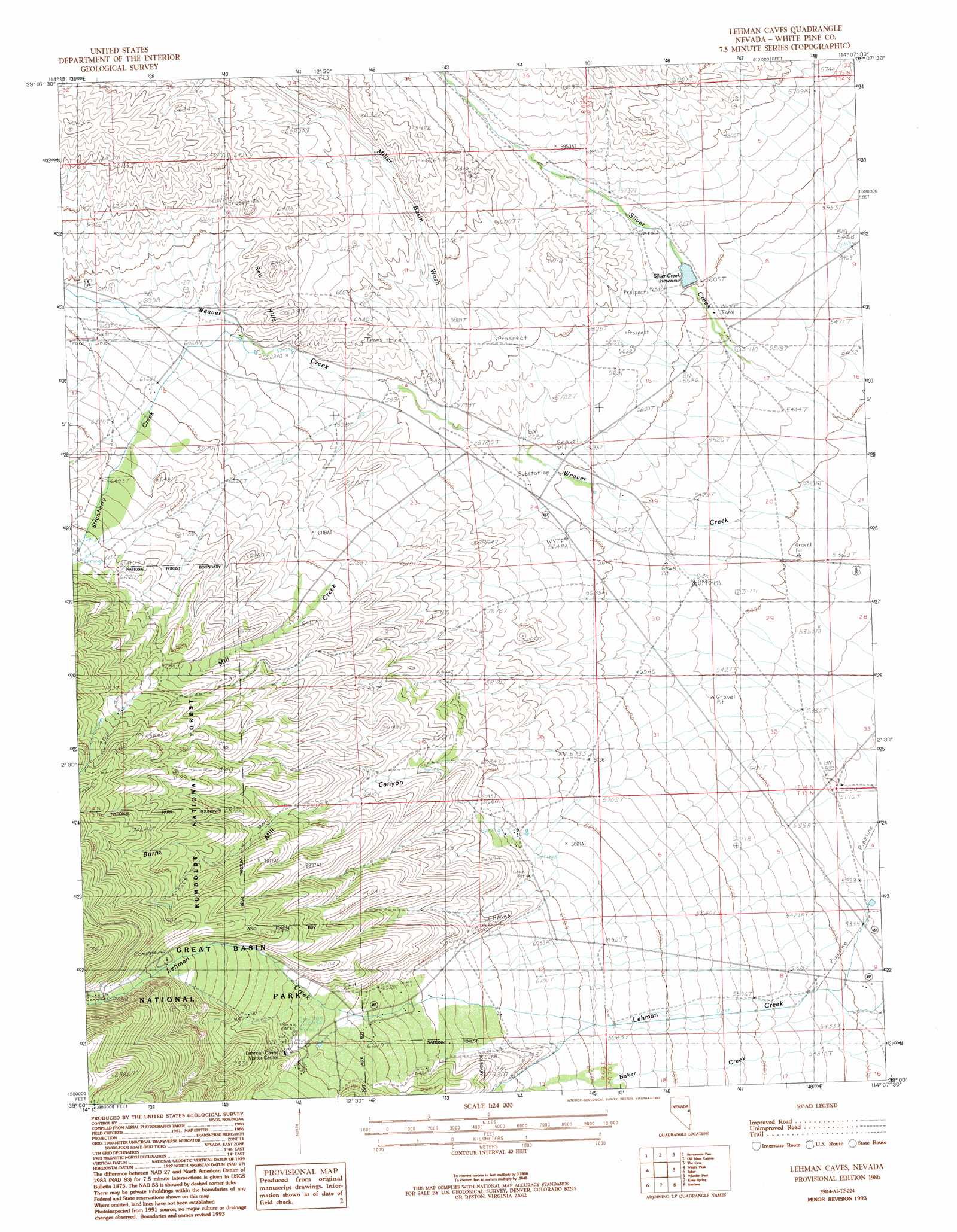
USGS Topo Quad 39114a2 - 1:24,000 scale
| Topo Map Name: | Lehman Caves |
| USGS Topo Quad ID: | 39114a2 |
| Print Size: | ca. 21 1/4" wide x 27" high |
| Southeast Coordinates: | 39° N latitude / 114.125° W longitude |
| Map Center Coordinates: | 39.0625° N latitude / 114.1875° W longitude |
| U.S. State: | NV |
| Filename: | o39114a2.jpg |
| Download Map JPG Image: | Lehman Caves topo map 1:24,000 scale |
| Map Type: | Topographic |
| Topo Series: | 7.5´ |
| Map Scale: | 1:24,000 |
| Source of Map Images: | United States Geological Survey (USGS) |
| Alternate Map Versions: |
Lehman Caves NV 1986, updated 1986 Download PDF Buy paper map Lehman Caves NV 1986, updated 1993 Download PDF Buy paper map Lehman Caves NV 2012 Download PDF Buy paper map Lehman Caves NV 2014 Download PDF Buy paper map |
| FStopo: | US Forest Service topo Lehman Caves is available: Download FStopo PDF Download FStopo TIF |
1:24,000 Topo Quads surrounding Lehman Caves
Yelland Dry Lake |
Sixmile Canyon |
Mount Moriah |
Little Horse Canyon |
Gandy Sw |
South Bastian Spring |
Sacramento Pass |
Old Mans Canyon |
The Cove |
Hole In The Ground |
Hogum |
Windy Peak |
Lehman Caves |
Baker |
Eskdale |
Baking Powder Flat |
Wheeler Peak |
Kious Spring |
Garrison |
Burbank Pass |
Minerva |
Minerva Canyon |
Arch Canyon |
Needle Point Spring |
Cedar Pass |
> Back to 39114a1 at 1:100,000 scale
> Back to 39114a1 at 1:250,000 scale
> Back to U.S. Topo Maps home
Lehman Caves topo map: Gazetteer
Lehman Caves: Dams
Silver Creek Dam elevation 1708m 5603′Lehman Caves: Mines
Bellander Mine elevation 1853m 6079′Lehman Caves: Parks
Lehman Caves National Monument (historical) elevation 2083m 6833′Lehman Caves: Ranges
Red Hills elevation 1890m 6200′Lehman Caves: Reservoirs
Silver Creek Reservoir elevation 1708m 5603′Lehman Caves: Springs
Bone Spring elevation 1807m 5928′Strawberry Spring elevation 1869m 6131′
Lehman Caves: Streams
Mill Creek elevation 1728m 5669′Miller Basin Wash elevation 1745m 5725′
Strawberry Creek elevation 1842m 6043′
Lehman Caves: Valleys
Burnt Mill Canyon elevation 2229m 7312′Lehman Caves digital topo map on disk
Buy this Lehman Caves topo map showing relief, roads, GPS coordinates and other geographical features, as a high-resolution digital map file on DVD: