Ruth Topo Map Nevada
To zoom in, hover over the map of Ruth
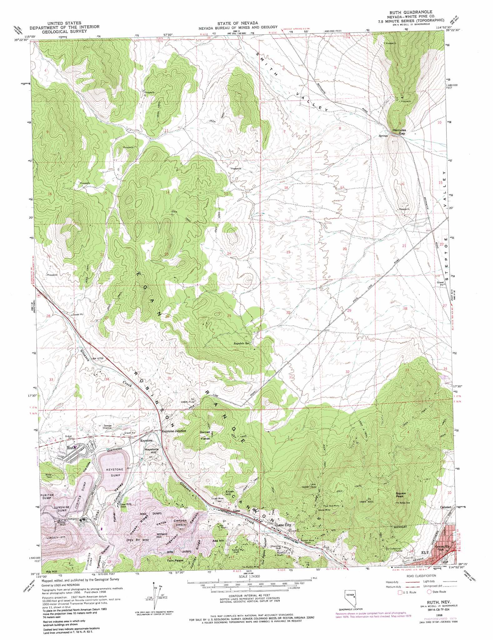
USGS Topo Quad 39114c8 - 1:24,000 scale
| Topo Map Name: | Ruth |
| USGS Topo Quad ID: | 39114c8 |
| Print Size: | ca. 21 1/4" wide x 27" high |
| Southeast Coordinates: | 39.25° N latitude / 114.875° W longitude |
| Map Center Coordinates: | 39.3125° N latitude / 114.9375° W longitude |
| U.S. State: | NV |
| Filename: | o39114c8.jpg |
| Download Map JPG Image: | Ruth topo map 1:24,000 scale |
| Map Type: | Topographic |
| Topo Series: | 7.5´ |
| Map Scale: | 1:24,000 |
| Source of Map Images: | United States Geological Survey (USGS) |
| Alternate Map Versions: |
Ruth NV 1958, updated 1960 Download PDF Buy paper map Ruth NV 1958, updated 1979 Download PDF Buy paper map Ruth NV 1958, updated 1985 Download PDF Buy paper map Ruth NV 2012 Download PDF Buy paper map Ruth NV 2014 Download PDF Buy paper map |
1:24,000 Topo Quads surrounding Ruth
Thirtymile Ranch |
Combs Creek |
Steptoe Ranch |
Steptoe |
Kalamazoo Summit |
Marking Corral Summit |
Robinson Summit |
Lusetti Canyon |
Mcgill |
Duck Creek Valley |
Waldy Pond |
Riepetown |
Ruth |
East Ely |
Cleve Creek Baldy |
Railroad Crossing Dam |
Giroux Wash |
Ely |
Comins Lake |
Cave Creek |
Blackjack Springs |
Preston Reservoir |
Ward Mountain |
Ward Charcoal Ovens |
Connors Pass |
> Back to 39114a1 at 1:100,000 scale
> Back to 39114a1 at 1:250,000 scale
> Back to U.S. Topo Maps home
Ruth topo map: Gazetteer
Ruth: Areas
Garnet Fields Rockhound Area elevation 2183m 7162′Ruth: Flats
Garnet Fields elevation 2197m 7208′Puritan Dump elevation 2171m 7122′
Stillwater Dump elevation 2226m 7303′
Sunshine Dump elevation 2170m 7119′
Ruth: Gaps
Hercules Gap elevation 1901m 6236′Ruth: Mines
Ada Shaft elevation 2085m 6840′Aultman Mine elevation 2016m 6614′
Boston Mine Shaft elevation 2003m 6571′
Brilliant Shaft elevation 2143m 7030′
Chainman Shaft elevation 2045m 6709′
Clipper Shaft elevation 2146m 7040′
Columbia Shaft elevation 2115m 6938′
Deep Ruth Shaft elevation 2106m 6909′
Deuce Mine elevation 2166m 7106′
Elijah Mine elevation 2062m 6765′
Ely-Centennial Tunnel elevation 2031m 6663′
Eureka Shaft elevation 2168m 7112′
Four Ace Mine elevation 2257m 7404′
Garnet Hill Mine elevation 2176m 7139′
Hayes Shaft elevation 2186m 7171′
Isaacs Mine elevation 2075m 6807′
Juniper Shaft elevation 2125m 6971′
Keystone Mine elevation 2084m 6837′
Kimbley Pit elevation 2000m 6561′
Liberty Pit elevation 2004m 6574′
Monitor Shaft elevation 2145m 7037′
Monroe Mine elevation 2160m 7086′
Revenue Shaft elevation 2115m 6938′
Ruth Shaft elevation 2149m 7050′
Saxton Shaft elevation 2123m 6965′
Star Pointer Shaft elevation 2169m 7116′
The Rabbit Mine elevation 2161m 7089′
Wedge Pit elevation 2075m 6807′
Willard Mine elevation 2149m 7050′
Witch Shaft elevation 2103m 6899′
Ruth: Populated Places
Calumet elevation 1950m 6397′Copper Flat elevation 2157m 7076′
Keystone elevation 2051m 6729′
Keystone Junction elevation 2047m 6715′
Lane City elevation 2011m 6597′
Mineral City elevation 2016m 6614′
Ruth elevation 2094m 6870′
Ruth (historical) elevation 2157m 7076′
Sunshine Camp (historical) elevation 2139m 7017′
Ruth: Post Offices
Lane Post Office elevation 2011m 6597′Ruth Post Office elevation 2094m 6870′
Ruth: Ridges
Hayes Ridge elevation 2187m 7175′Jupiter Ridge elevation 2158m 7080′
Ruth: Slopes
The Cliffs elevation 2121m 6958′Ruth: Springs
Bolo Spring elevation 2010m 6594′Ragsdale Spring elevation 2029m 6656′
Watson Spring elevation 2008m 6587′
Ruth: Summits
Ada Hill elevation 2142m 7027′Elijah Hill elevation 2138m 7014′
Garnet Hill elevation 2335m 7660′
Keystone Hill elevation 2121m 6958′
Squaw Peak elevation 2416m 7926′
Twin Peaks elevation 2176m 7139′
Willard Hill elevation 2176m 7139′
Ruth: Valleys
Fisher Canyon elevation 2100m 6889′Ingersol Canyon elevation 2022m 6633′
Lane Valley elevation 1995m 6545′
Ocher Valley elevation 2076m 6811′
Smith Valley elevation 1903m 6243′
The Rabbit Canyon elevation 2012m 6601′
Tonopah Canyon elevation 2165m 7103′
Verza Canyon elevation 2112m 6929′
Ruth digital topo map on disk
Buy this Ruth topo map showing relief, roads, GPS coordinates and other geographical features, as a high-resolution digital map file on DVD: