Mount Hamilton Topo Map Nevada
To zoom in, hover over the map of Mount Hamilton
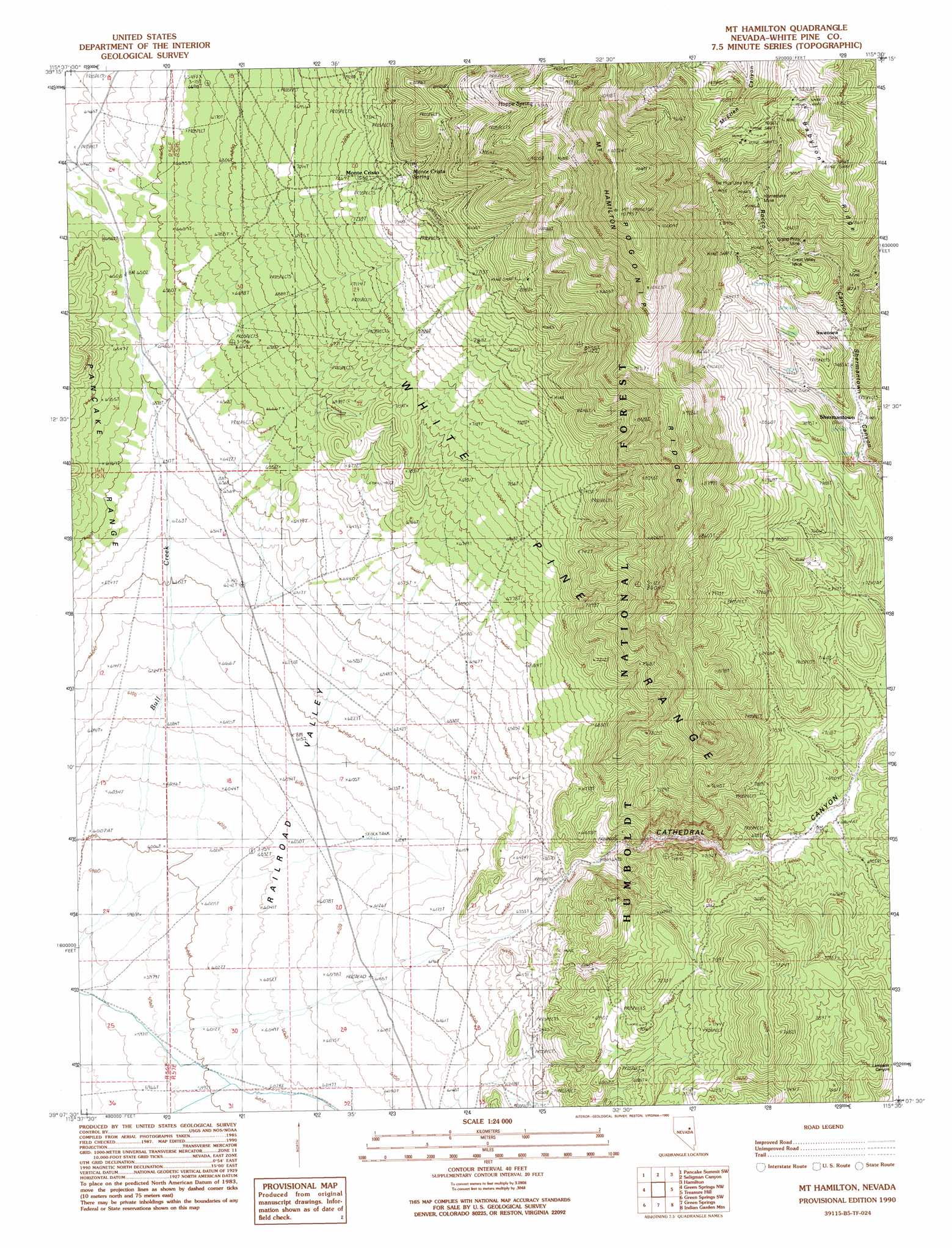
USGS Topo Quad 39115b5 - 1:24,000 scale
| Topo Map Name: | Mount Hamilton |
| USGS Topo Quad ID: | 39115b5 |
| Print Size: | ca. 21 1/4" wide x 27" high |
| Southeast Coordinates: | 39.125° N latitude / 115.5° W longitude |
| Map Center Coordinates: | 39.1875° N latitude / 115.5625° W longitude |
| U.S. State: | NV |
| Filename: | o39115b5.jpg |
| Download Map JPG Image: | Mount Hamilton topo map 1:24,000 scale |
| Map Type: | Topographic |
| Topo Series: | 7.5´ |
| Map Scale: | 1:24,000 |
| Source of Map Images: | United States Geological Survey (USGS) |
| Alternate Map Versions: |
Mt. Hamilton NV 1990, updated 1990 Download PDF Buy paper map Mount Hamilton NV 2012 Download PDF Buy paper map Mount Hamilton NV 2014 Download PDF Buy paper map |
| FStopo: | US Forest Service topo Mount Hamilton is available: Download FStopo PDF Download FStopo TIF |
1:24,000 Topo Quads surrounding Mount Hamilton
Silverado Mountain |
Pancake Summit |
East Of Pancake Summit |
Antelope Mountain |
Sammys Springs |
Black Point |
Pancake Summit Sw |
Seligman Canyon |
Hamilton |
Illipah |
Pogues Station |
Green Springs Nw |
Mount Hamilton |
Treasure Hill |
Limestone Peak |
Bull Fork |
Green Springs Sw |
Green Springs |
Indian Garden Mountain |
Easter Springs |
Brown Summit |
Duckwater |
Duckwater Ne |
Currant Mountain |
Horse Track Spring |
> Back to 39115a1 at 1:100,000 scale
> Back to 39114a1 at 1:250,000 scale
> Back to U.S. Topo Maps home
Mount Hamilton topo map: Gazetteer
Mount Hamilton: Mines
Caroline Mine elevation 2294m 7526′Enterprise Mine elevation 2533m 8310′
Grand Prize Mine elevation 2524m 8280′
Great Valley Mine elevation 2470m 8103′
Homestake Mine elevation 2662m 8733′
Ne Plus Ultra Mine elevation 2627m 8618′
Ora Mine elevation 2426m 7959′
Rocco Homestake Mine elevation 2667m 8750′
Mount Hamilton: Populated Places
Babylon (historical) elevation 2775m 9104′Shermantown elevation 2251m 7385′
Swansea (historical) elevation 2433m 7982′
Mount Hamilton: Post Offices
Shermantown Post Office (historical) elevation 2251m 7385′Mount Hamilton: Ridges
Pogonip Ridge elevation 2790m 9153′Mount Hamilton: Springs
Hoppe Spring elevation 2787m 9143′Monte Cristo Spring elevation 2300m 7545′
Mount Hamilton: Summits
Mount Hamilton elevation 3261m 10698′Mount Hamilton: Valleys
Cathedral Canyon elevation 1890m 6200′Rocco Canyon elevation 2316m 7598′
Mount Hamilton: Wells
Cathedral Well elevation 1858m 6095′Mount Hamilton digital topo map on disk
Buy this Mount Hamilton topo map showing relief, roads, GPS coordinates and other geographical features, as a high-resolution digital map file on DVD: