Hamilton Topo Map Nevada
To zoom in, hover over the map of Hamilton
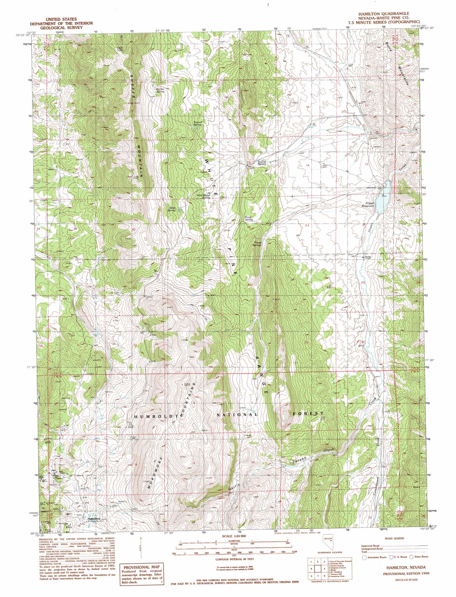
USGS Topo Quad 39115c4 - 1:24,000 scale
| Topo Map Name: | Hamilton |
| USGS Topo Quad ID: | 39115c4 |
| Print Size: | ca. 21 1/4" wide x 27" high |
| Southeast Coordinates: | 39.25° N latitude / 115.375° W longitude |
| Map Center Coordinates: | 39.3125° N latitude / 115.4375° W longitude |
| U.S. State: | NV |
| Filename: | o39115c4.jpg |
| Download Map JPG Image: | Hamilton topo map 1:24,000 scale |
| Map Type: | Topographic |
| Topo Series: | 7.5´ |
| Map Scale: | 1:24,000 |
| Source of Map Images: | United States Geological Survey (USGS) |
| Alternate Map Versions: |
Hamilton NV 1990, updated 1990 Download PDF Buy paper map Hamilton NV 2012 Download PDF Buy paper map Hamilton NV 2014 Download PDF Buy paper map |
| FStopo: | US Forest Service topo Hamilton is available: Download FStopo PDF Download FStopo TIF |
1:24,000 Topo Quads surrounding Hamilton
West Of Beck Pass |
Beck Pass |
Sunshine Well |
Dickenson Well |
Thirtymile Ranch |
Pancake Summit |
East Of Pancake Summit |
Antelope Mountain |
Sammys Springs |
Marking Corral Summit |
Pancake Summit Sw |
Seligman Canyon |
Hamilton |
Illipah |
Waldy Pond |
Green Springs Nw |
Mount Hamilton |
Treasure Hill |
Limestone Peak |
Railroad Crossing Dam |
Green Springs Sw |
Green Springs |
Indian Garden Mountain |
Easter Springs |
Blackjack Springs |
> Back to 39115a1 at 1:100,000 scale
> Back to 39114a1 at 1:250,000 scale
> Back to U.S. Topo Maps home
Hamilton topo map: Gazetteer
Hamilton: Dams
Illipah Creek Dam elevation 2071m 6794′Hamilton: Populated Places
Hamilton elevation 2456m 8057′Hamilton: Post Offices
Hamilton Post Office (historical) elevation 2456m 8057′Hamilton: Reservoirs
Illipah Creek Reservoir elevation 2071m 6794′Von Schmidt Reservoir (historical) elevation 2480m 8136′
Hamilton: Springs
Barrel Spring elevation 2324m 7624′California Spring elevation 2376m 7795′
California Spring Number 2 elevation 2545m 8349′
Chicken Spring elevation 2256m 7401′
Halstead Spring elevation 2088m 6850′
Illipah Spring elevation 2546m 8353′
Poison Spring elevation 2443m 8015′
Pond Spring elevation 2186m 7171′
Prune Springs elevation 2185m 7168′
Rosebud Spring elevation 2370m 7775′
Round Spring elevation 2131m 6991′
Sand Spring elevation 2299m 7542′
Tunnel Spring elevation 2282m 7486′
Waterworks Spring elevation 2426m 7959′
Wild Horse Spring elevation 2181m 7155′
Hamilton: Streams
Cottonwood Creek elevation 2137m 7011′Hamilton: Summits
Buster Mountain elevation 2624m 8608′Hamilton: Tunnels
White Pine Water Works Tunnel (historical) elevation 2525m 8284′Hamilton: Valleys
Harris Canyon elevation 2104m 6902′Hamilton digital topo map on disk
Buy this Hamilton topo map showing relief, roads, GPS coordinates and other geographical features, as a high-resolution digital map file on DVD: