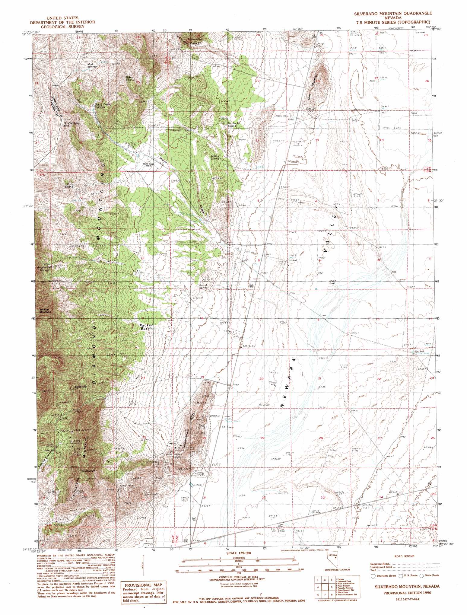
Silverado Mountain Topo Map Nevada
To zoom in, hover over the map of Silverado Mountain
USGS Topo Quad 39115d7 - 1:24,000 scale
| Topo Map Name: | Silverado Mountain |
| USGS Topo Quad ID: | 39115d7 |
| Print Size: | ca. 21 1/4" wide x 27" high |
| Southeast Coordinates: | 39.375° N latitude / 115.75° W longitude |
| Map Center Coordinates: | 39.4375° N latitude / 115.8125° W longitude |
| U.S. State: | NV |
| Filename: | o39115d7.jpg |
| Download Map JPG Image: | Silverado Mountain topo map 1:24,000 scale |
| Map Type: | Topographic |
| Topo Series: | 7.5´ |
| Map Scale: | 1:24,000 |
| Source of Map Images: | United States Geological Survey (USGS) |
| Alternate Map Versions: |
Silverado Mountain NV 1990, updated 1990 Download PDF Buy paper map Silverado Mountain NV 2012 Download PDF Buy paper map Silverado Mountain NV 2014 Download PDF Buy paper map |
1:24,000 Topo Quads surrounding Silverado Mountain
Whistler Mountain |
North Of Eureka |
Rattlesnake Mountain |
Buck Mountain West |
Buck Mountain East |
Devon Peak |
Eureka |
Diamond Peak |
West Of Beck Pass |
Beck Pass |
Spring Valley Summit |
Pinto Summit |
Silverado Mountain |
Pancake Summit |
East Of Pancake Summit |
Bellevue Peak |
Pinto Summit Sw |
Black Point |
Pancake Summit Sw |
Seligman Canyon |
Eightmile Well |
Moody Peak Nw |
Pogues Station |
Green Springs Nw |
Mount Hamilton |
> Back to 39115a1 at 1:100,000 scale
> Back to 39114a1 at 1:250,000 scale
> Back to U.S. Topo Maps home
Silverado Mountain topo map: Gazetteer
Silverado Mountain: Basins
Packer Basin elevation 1917m 6289′Silverado Mountain: Mines
Autumn Number Two Mine elevation 2116m 6942′Champion Mine elevation 1878m 6161′
Cole and Johnson Mine elevation 1922m 6305′
Duquette Mine elevation 2116m 6942′
Fair Play Mine elevation 1920m 6299′
Lewis Deralls Shaft elevation 1928m 6325′
Maryland Mine elevation 2116m 6942′
Michigan Mine elevation 2112m 6929′
Our Own Mine elevation 2112m 6929′
Queen Mine elevation 2209m 7247′
Rescue Mine elevation 2194m 7198′
Silver Stone Mine elevation 2116m 6942′
Silverado Mine elevation 2116m 6942′
Smith Mine elevation 1899m 6230′
Sun Burst Mine elevation 1865m 6118′
Uncle Sam Mine elevation 2112m 6929′
Washington Mine elevation 2116m 6942′
Silverado Mountain: Populated Places
Pinto (historical) elevation 2134m 7001′Silverado Mountain: Post Offices
Pinto Post Office (historical) elevation 2134m 7001′Silverado Mountain: Springs
Barrel Spring elevation 1873m 6145′Indian Spring elevation 1889m 6197′
Mikes Spring elevation 2131m 6991′
Muchacho Spring elevation 1905m 6250′
Mud Springs elevation 2205m 7234′
Pinto Creek Springs elevation 2126m 6975′
Rose Spring elevation 2135m 7004′
Silverado Mountain: Streams
Pinto Creek elevation 1979m 6492′Silverado Mountain: Summits
Alhambra Hills elevation 1947m 6387′Century Peak elevation 2334m 7657′
Island Mountain elevation 2230m 7316′
Lone Mountain elevation 1943m 6374′
Silverado Mountain elevation 2294m 7526′
Strahlenberg elevation 2304m 7559′
Silverado Mountain: Valleys
Tollhouse Canyon elevation 1930m 6332′Silverado Mountain: Wells
Lagari Well elevation 1810m 5938′Silverado Mountain digital topo map on disk
Buy this Silverado Mountain topo map showing relief, roads, GPS coordinates and other geographical features, as a high-resolution digital map file on DVD: