Bartine Ranch Topo Map Nevada
To zoom in, hover over the map of Bartine Ranch
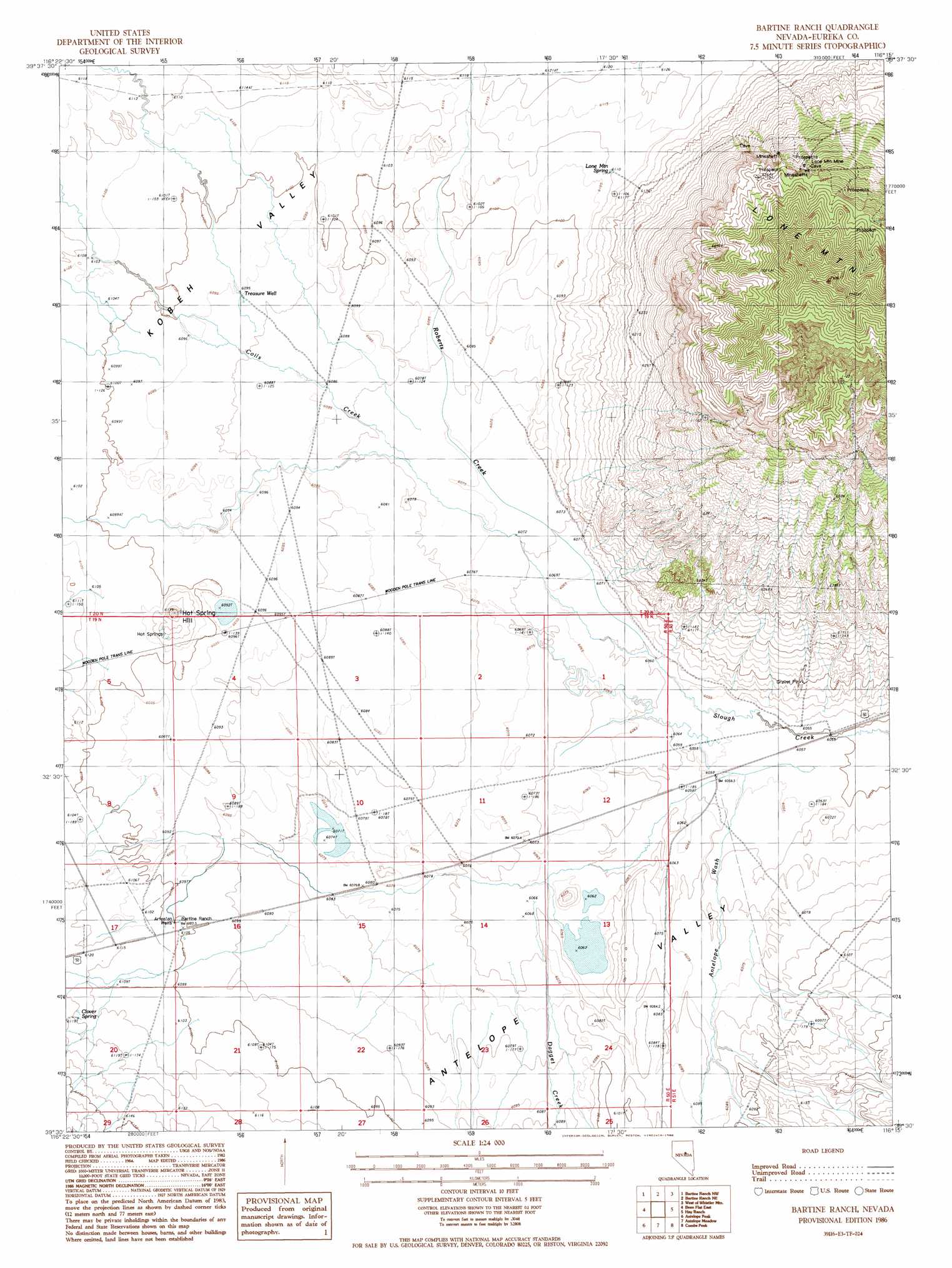
USGS Topo Quad 39116e3 - 1:24,000 scale
| Topo Map Name: | Bartine Ranch |
| USGS Topo Quad ID: | 39116e3 |
| Print Size: | ca. 21 1/4" wide x 27" high |
| Southeast Coordinates: | 39.5° N latitude / 116.25° W longitude |
| Map Center Coordinates: | 39.5625° N latitude / 116.3125° W longitude |
| U.S. State: | NV |
| Filename: | o39116e3.jpg |
| Download Map JPG Image: | Bartine Ranch topo map 1:24,000 scale |
| Map Type: | Topographic |
| Topo Series: | 7.5´ |
| Map Scale: | 1:24,000 |
| Source of Map Images: | United States Geological Survey (USGS) |
| Alternate Map Versions: |
Bartine Ranch NV 1986, updated 1986 Download PDF Buy paper map Bartine Ranch NV 2012 Download PDF Buy paper map Bartine Ranch NV 2015 Download PDF Buy paper map |
1:24,000 Topo Quads surrounding Bartine Ranch
Fagin Mountain |
Three Bar Ranch |
Roberts Creek Mountain |
Garden Pass |
Tule Dam Spring |
Shagnasty |
Bartine Ranch Nw |
Bartine Ranch Ne |
West Of Whistler Mountain |
Whistler Mountain |
Bean Flat West |
Bean Flat East |
Bartine Ranch |
Hay Ranch |
Devon Peak |
Jackrabbit Spring |
Antelope Peak |
Antelope Meadow |
Combs Peak |
Spring Valley Summit |
Wallace Canyon |
Well Canyon |
Sullivan Wash |
West Of Bellevue Peak |
Bellevue Peak |
> Back to 39116e1 at 1:100,000 scale
> Back to 39116a1 at 1:250,000 scale
> Back to U.S. Topo Maps home
Bartine Ranch topo map: Gazetteer
Bartine Ranch: Mines
Lone Mountain Mine elevation 1978m 6489′Mountain View Extension Mine elevation 1979m 6492′
Mountain View Mine elevation 1991m 6532′
Bartine Ranch: Springs
Clover Spring elevation 1866m 6122′Hot Springs elevation 1866m 6122′
Lone Mountain Spring elevation 1864m 6115′
Bartine Ranch: Streams
Antelope Wash elevation 1844m 6049′Coils Creek elevation 1848m 6062′
Dagget Creek elevation 1851m 6072′
Roberts Creek elevation 1848m 6062′
Rutabaga Creek elevation 1860m 6102′
Bartine Ranch: Summits
Hot Spring Hill elevation 1879m 6164′Lone Mountain elevation 2397m 7864′
Bartine Ranch: Wells
Treasure Well elevation 1859m 6099′Bartine Ranch digital topo map on disk
Buy this Bartine Ranch topo map showing relief, roads, GPS coordinates and other geographical features, as a high-resolution digital map file on DVD: