Three Bar Ranch Topo Map Nevada
To zoom in, hover over the map of Three Bar Ranch
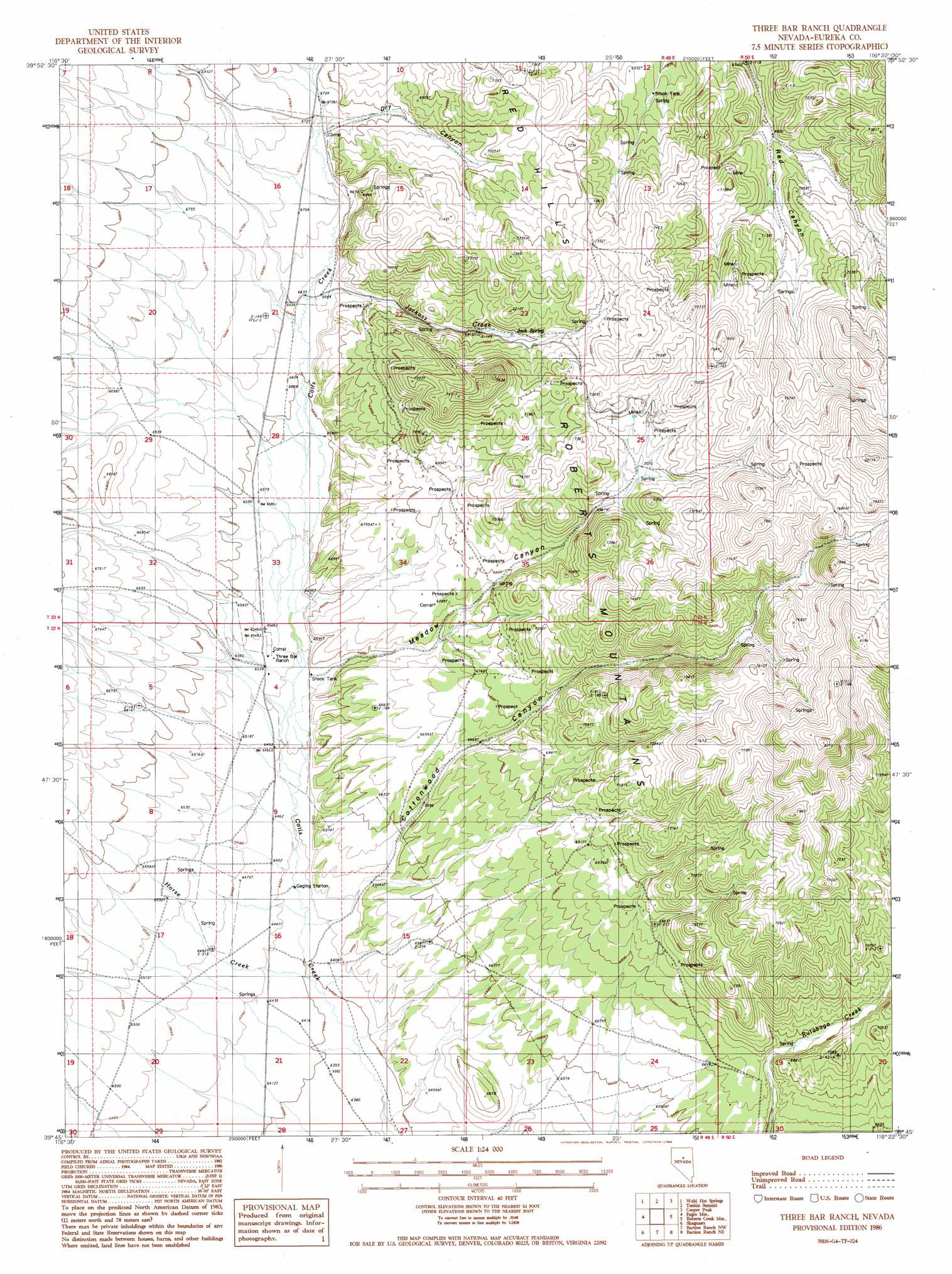
USGS Topo Quad 39116g4 - 1:24,000 scale
| Topo Map Name: | Three Bar Ranch |
| USGS Topo Quad ID: | 39116g4 |
| Print Size: | ca. 21 1/4" wide x 27" high |
| Southeast Coordinates: | 39.75° N latitude / 116.375° W longitude |
| Map Center Coordinates: | 39.8125° N latitude / 116.4375° W longitude |
| U.S. State: | NV |
| Filename: | o39116g4.jpg |
| Download Map JPG Image: | Three Bar Ranch topo map 1:24,000 scale |
| Map Type: | Topographic |
| Topo Series: | 7.5´ |
| Map Scale: | 1:24,000 |
| Source of Map Images: | United States Geological Survey (USGS) |
| Alternate Map Versions: |
Three Bar Ranch NV 1986, updated 1986 Download PDF Buy paper map Three Bar Ranch NV 2012 Download PDF Buy paper map Three Bar Ranch NV 2014 Download PDF Buy paper map |
1:24,000 Topo Quads surrounding Three Bar Ranch
Wenban Spring |
Dugout Spring |
Rocky Hills |
Pete Hanson Creek |
Mineral Hill Sw |
Little Hot Springs |
Walti Hot Springs |
Tonkin Summit |
Cooper Peak |
Frazier Creek |
West Of Fagin Mountain |
Fagin Mountain |
Three Bar Ranch |
Roberts Creek Mountain |
Garden Pass |
Salt Marsh Canyon |
Shagnasty |
Bartine Ranch Nw |
Bartine Ranch Ne |
West Of Whistler Mountain |
Ackerman Canyon |
Bean Flat West |
Bean Flat East |
Bartine Ranch |
Hay Ranch |
> Back to 39116e1 at 1:100,000 scale
> Back to 39116a1 at 1:250,000 scale
> Back to U.S. Topo Maps home
Three Bar Ranch topo map: Gazetteer
Three Bar Ranch: Populated Places
Three Bar (historical) elevation 1992m 6535′Three Bar Ranch: Post Offices
Bar Post Office (historical) elevation 1992m 6535′Three Bar Ranch: Springs
Deer Spring elevation 2437m 7995′East Cottonwood Springs elevation 2299m 7542′
Jack Spring elevation 2146m 7040′
Rutabaga Spring elevation 2054m 6738′
Three Bar Ranch: Streams
Horse Creek elevation 1952m 6404′Jackass Creek elevation 2025m 6643′
North Branch Horse Creek elevation 1961m 6433′
Three Bar Ranch: Summits
Red Hills elevation 2234m 7329′Three Bar Ranch: Valleys
Cottonwood Canyon elevation 1973m 6473′Dry Canyon elevation 2049m 6722′
Jackass Canyon elevation 2037m 6683′
Meadow Canyon elevation 1995m 6545′
Three Bar Ranch digital topo map on disk
Buy this Three Bar Ranch topo map showing relief, roads, GPS coordinates and other geographical features, as a high-resolution digital map file on DVD: