Millett Ranch Topo Map Nevada
To zoom in, hover over the map of Millett Ranch
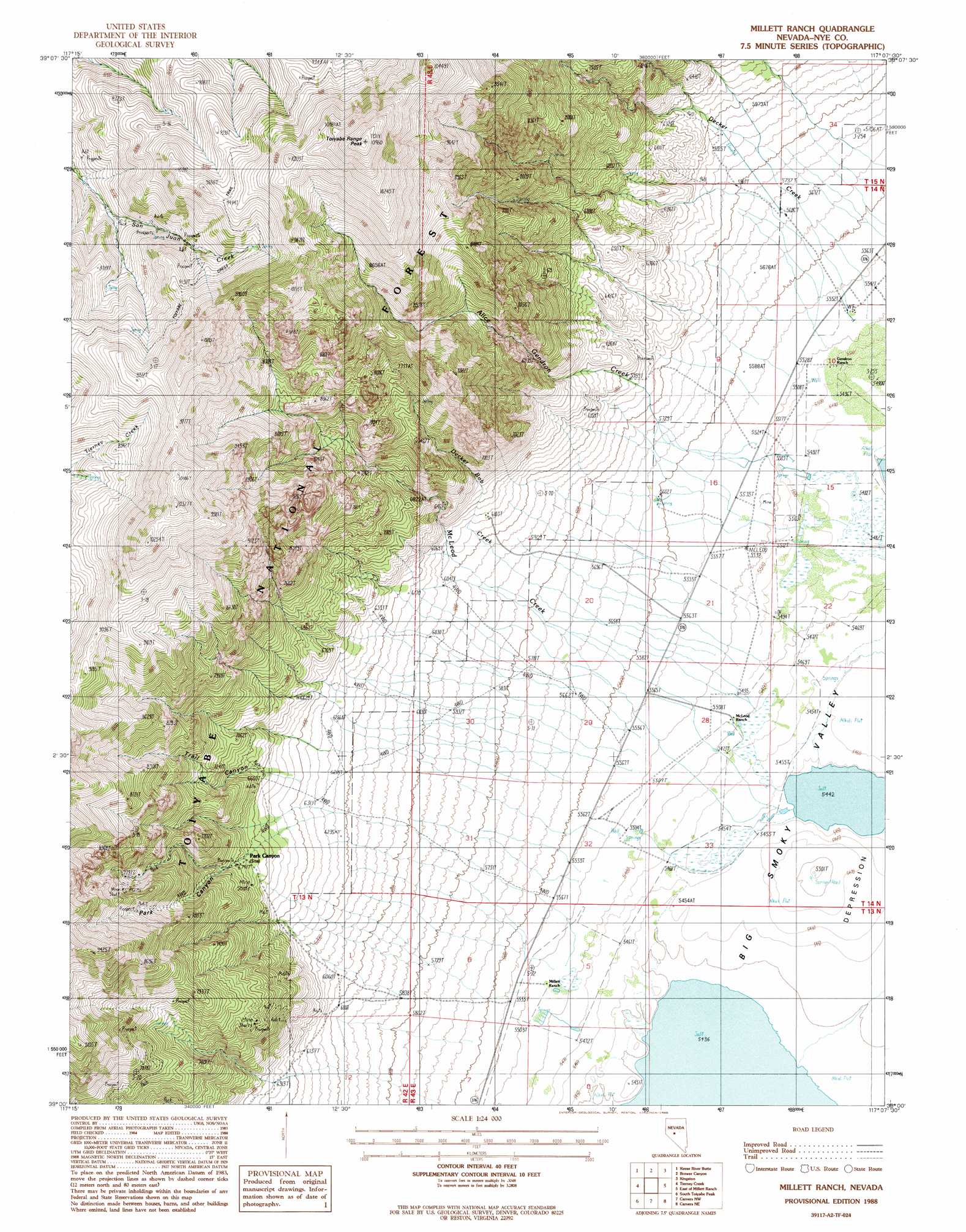
USGS Topo Quad 39117a2 - 1:24,000 scale
| Topo Map Name: | Millett Ranch |
| USGS Topo Quad ID: | 39117a2 |
| Print Size: | ca. 21 1/4" wide x 27" high |
| Southeast Coordinates: | 39° N latitude / 117.125° W longitude |
| Map Center Coordinates: | 39.0625° N latitude / 117.1875° W longitude |
| U.S. State: | NV |
| Filename: | o39117a2.jpg |
| Download Map JPG Image: | Millett Ranch topo map 1:24,000 scale |
| Map Type: | Topographic |
| Topo Series: | 7.5´ |
| Map Scale: | 1:24,000 |
| Source of Map Images: | United States Geological Survey (USGS) |
| Alternate Map Versions: |
Millett Ranch NV 1988, updated 1988 Download PDF Buy paper map Millett Ranch NV 2012 Download PDF Buy paper map Millett Ranch NV 2015 Download PDF Buy paper map |
| FStopo: | US Forest Service topo Millett Ranch is available: Download FStopo PDF Download FStopo TIF |
1:24,000 Topo Quads surrounding Millett Ranch
Iron Mountain |
Dutch Flat |
Bunker Hill |
North Toiyabe Peak |
Birch Creek Ranch |
North Shoshone Peak |
Reese River Butte |
Brewer Canyon |
Kingston |
Wildcat Peak Nw |
Barrett Canyon |
Tierney Creek |
Millett Ranch |
East Of Millett Ranch |
Wildcat Canyon |
Corral Wash |
South Toiyabe Peak |
Carvers Nw |
Carvers Ne |
Jet Spring |
Bakeoven Creek |
Arc Dome |
Carvers |
Carvers Se |
Mount Jefferson |
> Back to 39117a1 at 1:100,000 scale
> Back to 39116a1 at 1:250,000 scale
> Back to U.S. Topo Maps home
Millett Ranch topo map: Gazetteer
Millett Ranch: Arroyos
Timblin Creek elevation 2118m 6948′Millett Ranch: Mines
Giant Mine elevation 2592m 8503′Gold Pocket Mine elevation 2074m 6804′
Grandview Mine elevation 2561m 8402′
McIntyre Mine elevation 2649m 8690′
McIntyre Mine elevation 2571m 8435′
Millett Mine elevation 2205m 7234′
Saint Elena Patent elevation 2583m 8474′
Star Number One Mine elevation 1997m 6551′
Tungsten King Mine elevation 2486m 8156′
Valley View and Foothill Mine elevation 2052m 6732′
Viken Mine elevation 2196m 7204′
Millett Ranch: Populated Places
Junction (historical) elevation 1680m 5511′Millett elevation 1687m 5534′
Park Canyon (historical) elevation 2060m 6758′
Pueblo (historical) elevation 1848m 6062′
San Juan (historical) elevation 2463m 8080′
Millett Ranch: Post Offices
Junction Post Office (historical) elevation 1680m 5511′Millett Post Office (historical) elevation 1687m 5534′
Park Canyon Post Office (historical) elevation 2060m 6758′
Millett Ranch: Springs
McLeods Ranch Spring elevation 1676m 5498′Millett Ranch: Streams
Alice Gendron Creek elevation 1680m 5511′Decker Bob Creek elevation 1691m 5547′
Decker Creek elevation 1680m 5511′
McLeod Creek elevation 1662m 5452′
Millett Ranch: Summits
Toiyabe Range Peak elevation 3330m 10925′Millett Ranch: Trails
Fremont Route elevation 1697m 5567′Toiyabe Crest Trail elevation 2796m 9173′
Millett Ranch: Valleys
Park Canyon elevation 2050m 6725′Trail Canyon elevation 2012m 6601′
Millett Ranch digital topo map on disk
Buy this Millett Ranch topo map showing relief, roads, GPS coordinates and other geographical features, as a high-resolution digital map file on DVD: