Eastgate Topo Map Nevada
To zoom in, hover over the map of Eastgate
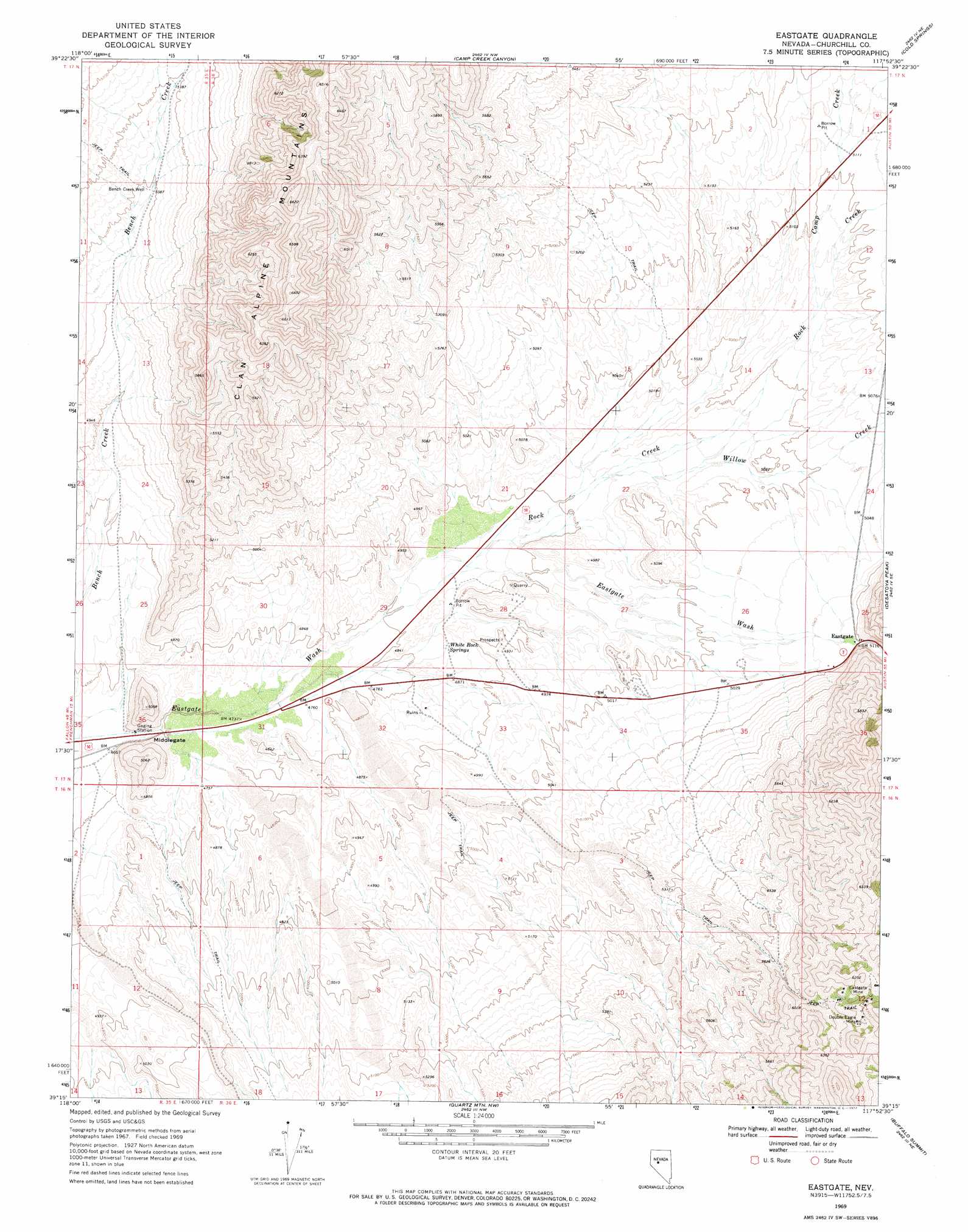
USGS Topo Quad 39117c8 - 1:24,000 scale
| Topo Map Name: | Eastgate |
| USGS Topo Quad ID: | 39117c8 |
| Print Size: | ca. 21 1/4" wide x 27" high |
| Southeast Coordinates: | 39.25° N latitude / 117.875° W longitude |
| Map Center Coordinates: | 39.3125° N latitude / 117.9375° W longitude |
| U.S. State: | NV |
| Filename: | o39117c8.jpg |
| Download Map JPG Image: | Eastgate topo map 1:24,000 scale |
| Map Type: | Topographic |
| Topo Series: | 7.5´ |
| Map Scale: | 1:24,000 |
| Source of Map Images: | United States Geological Survey (USGS) |
| Alternate Map Versions: |
Eastgate NV 1969, updated 1972 Download PDF Buy paper map Eastgate NV 2011 Download PDF Buy paper map Eastgate NV 2014 Download PDF Buy paper map |
1:24,000 Topo Quads surrounding Eastgate
Job Peak |
Dixie Valley Se |
Mount Augusta |
Clan Alpine Ranch |
Byers Ranch |
Pirouette Mountain |
Wonder Mountain |
Camp Creek Canyon |
Cold Springs |
Basque Summit |
Drumm Summit |
West Gate |
Eastgate |
Desatoya Peak |
Carroll Summit |
Bell Canyon |
Bell Mountain |
Quartz Mountain Nw |
Buffalo Summit |
Campbell Creek Ranch |
Slate Mountain |
Broken Hills |
Quartz Mountain |
Burnt Cabin Summit |
Midas Spring |
> Back to 39117a1 at 1:100,000 scale
> Back to 39116a1 at 1:250,000 scale
> Back to U.S. Topo Maps home
Eastgate topo map: Gazetteer
Eastgate: Gaps
Middlegate elevation 1428m 4685′Eastgate: Mines
Double Eagle Mine elevation 1867m 6125′Eastgate Mine elevation 1887m 6190′
Gold Ledge Mine elevation 1823m 5980′
Eastgate: Populated Places
Eastgate elevation 1553m 5095′Eastgate: Springs
White Rock Springs elevation 1470m 4822′Eastgate: Streams
Camp Creek elevation 1534m 5032′Eastgate Wash elevation 1427m 4681′
Rock Creek elevation 1477m 4845′
Willow Creek elevation 1500m 4921′
Eastgate: Wells
Bench Creek Well elevation 1554m 5098′Eastgate digital topo map on disk
Buy this Eastgate topo map showing relief, roads, GPS coordinates and other geographical features, as a high-resolution digital map file on DVD: