West Of Austin Topo Map Nevada
To zoom in, hover over the map of West Of Austin
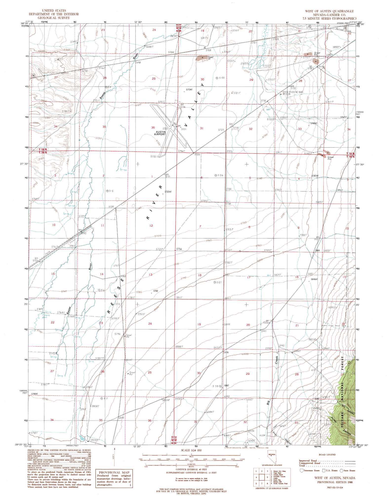
USGS Topo Quad 39117d2 - 1:24,000 scale
| Topo Map Name: | West Of Austin |
| USGS Topo Quad ID: | 39117d2 |
| Print Size: | ca. 21 1/4" wide x 27" high |
| Southeast Coordinates: | 39.375° N latitude / 117.125° W longitude |
| Map Center Coordinates: | 39.4375° N latitude / 117.1875° W longitude |
| U.S. State: | NV |
| Filename: | o39117d2.jpg |
| Download Map JPG Image: | West Of Austin topo map 1:24,000 scale |
| Map Type: | Topographic |
| Topo Series: | 7.5´ |
| Map Scale: | 1:24,000 |
| Source of Map Images: | United States Geological Survey (USGS) |
| Alternate Map Versions: |
West of Austin NV 1988, updated 1988 Download PDF Buy paper map West of Austin NV 2012 Download PDF Buy paper map West of Austin NV 2014 Download PDF Buy paper map |
| FStopo: | US Forest Service topo West of Austin is available: Download FStopo PDF Download FStopo TIF |
1:24,000 Topo Quads surrounding West Of Austin
New Pass Peak |
Mount Airy Ne |
Vigus Butte Nw |
Vigus Butte Ne |
Mount Callaghan |
Mount Airy |
Mount Airy Mesa |
Vigus Butte |
Yankee Blade |
Barton Spring |
Emigrant Peak |
Gandolfo Canyon |
West Of Austin |
Austin |
Simpson Park Canyon |
Iron Mountain |
Dutch Flat |
Bunker Hill |
North Toiyabe Peak |
Birch Creek Ranch |
North Shoshone Peak |
Reese River Butte |
Brewer Canyon |
Kingston |
Wildcat Peak Nw |
> Back to 39117a1 at 1:100,000 scale
> Back to 39116a1 at 1:250,000 scale
> Back to U.S. Topo Maps home
West Of Austin topo map: Gazetteer
West Of Austin: Airports
Austin Airport elevation 1747m 5731′West Of Austin: Populated Places
Canon City elevation 1797m 5895′Lander City (historical) elevation 1902m 6240′
West Of Austin: Streams
Big Creek elevation 1778m 5833′Birchum Slough elevation 1750m 5741′
Porter Creek elevation 1877m 6158′
West Of Austin: Valleys
Dry Canyon elevation 1928m 6325′First Canyon elevation 1908m 6259′
Indian Canyon elevation 1862m 6108′
Porter Canyon elevation 2040m 6692′
West Of Austin digital topo map on disk
Buy this West Of Austin topo map showing relief, roads, GPS coordinates and other geographical features, as a high-resolution digital map file on DVD: