Clan Alpine Ranch Topo Map Nevada
To zoom in, hover over the map of Clan Alpine Ranch
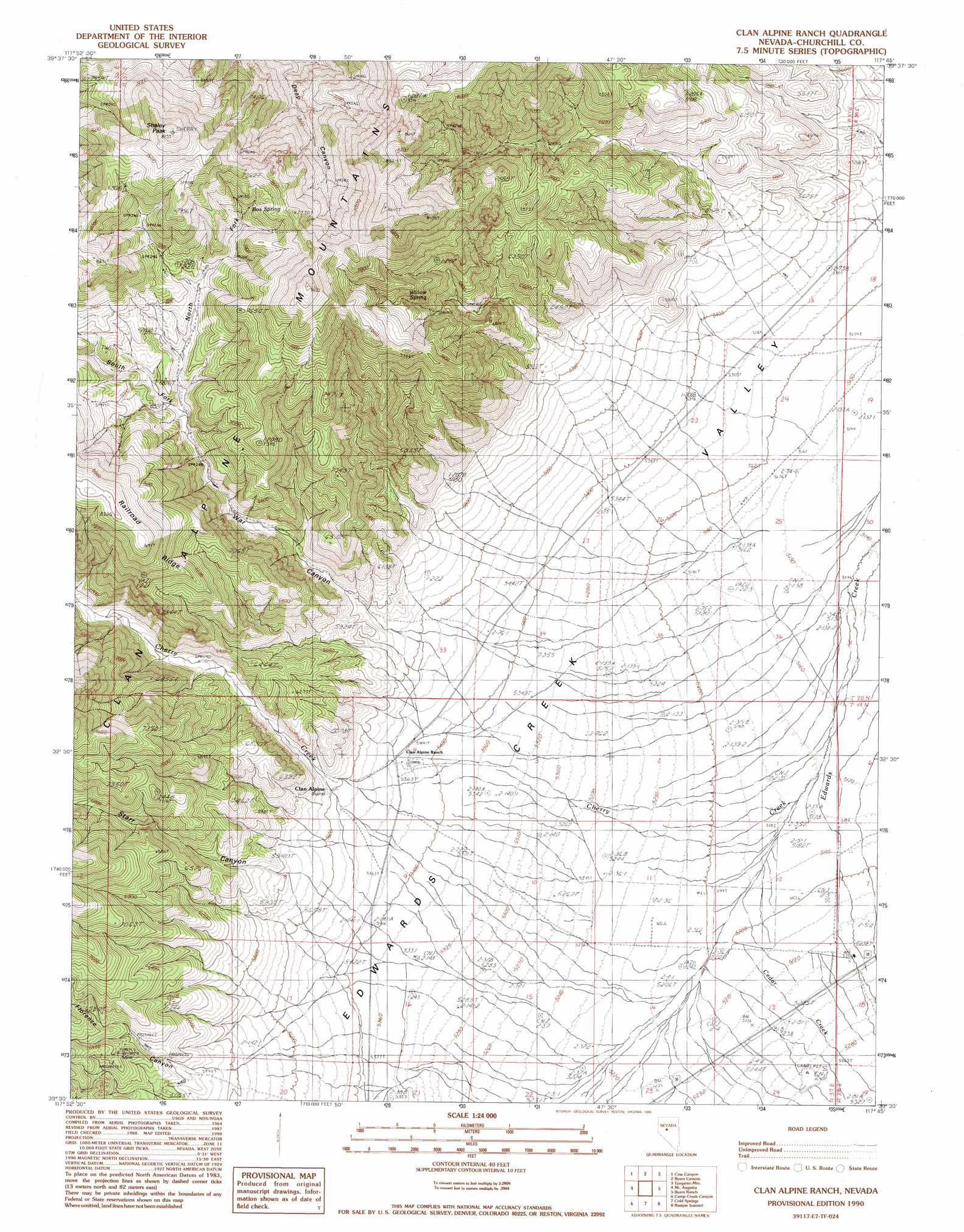
USGS Topo Quad 39117e7 - 1:24,000 scale
| Topo Map Name: | Clan Alpine Ranch |
| USGS Topo Quad ID: | 39117e7 |
| Print Size: | ca. 21 1/4" wide x 27" high |
| Southeast Coordinates: | 39.5° N latitude / 117.75° W longitude |
| Map Center Coordinates: | 39.5625° N latitude / 117.8125° W longitude |
| U.S. State: | NV |
| Filename: | o39117e7.jpg |
| Download Map JPG Image: | Clan Alpine Ranch topo map 1:24,000 scale |
| Map Type: | Topographic |
| Topo Series: | 7.5´ |
| Map Scale: | 1:24,000 |
| Source of Map Images: | United States Geological Survey (USGS) |
| Alternate Map Versions: |
Clan Alpine Ranch NV 1990, updated 1990 Download PDF Buy paper map Clan Alpine Ranch NV 2011 Download PDF Buy paper map Clan Alpine Ranch NV 2015 Download PDF Buy paper map |
1:24,000 Topo Quads surrounding Clan Alpine Ranch
Dixie Hot Springs |
Humboldt Salt Marsh |
Bernice Canyon |
Shoshone Meadows |
Shoshone Meadows Se |
Dixie Valley |
Cow Canyon |
Byers Canyon |
Tungsten Mountain |
New Pass Well |
Dixie Valley Se |
Mount Augusta |
Clan Alpine Ranch |
Byers Ranch |
New Pass |
Wonder Mountain |
Camp Creek Canyon |
Cold Springs |
Basque Summit |
Carroll Summit Ne |
West Gate |
Eastgate |
Desatoya Peak |
Carroll Summit |
Carroll Summit Se |
> Back to 39117e1 at 1:100,000 scale
> Back to 39116a1 at 1:250,000 scale
> Back to U.S. Topo Maps home
Clan Alpine Ranch topo map: Gazetteer
Clan Alpine Ranch: Airports
Hudson Airport elevation 1574m 5164′Clan Alpine Ranch: Populated Places
Clan Alpine (historical) elevation 1706m 5597′Edwards Creek Station (historical) elevation 1598m 5242′
Clan Alpine Ranch: Post Offices
Alpine Post Office elevation 1715m 5626′Healy Post Office (historical) elevation 1598m 5242′
Clan Alpine Ranch: Springs
Box Spring elevation 2269m 7444′Deep Canyon Spring elevation 2203m 7227′
Deer Canyon Spring elevation 2002m 6568′
Willow Spring elevation 2179m 7148′
Clan Alpine Ranch: Streams
Cedar Creek elevation 1587m 5206′Cherry Creek elevation 1586m 5203′
Clan Alpine Ranch: Summits
Shaley Peak elevation 2680m 8792′Clan Alpine Ranch: Valleys
Florence Canyon elevation 1703m 5587′North Fork War Canyon elevation 1986m 6515′
South Fork War Canyon elevation 1988m 6522′
Starr Canyon elevation 1760m 5774′
War Canyon elevation 1715m 5626′
Clan Alpine Ranch digital topo map on disk
Buy this Clan Alpine Ranch topo map showing relief, roads, GPS coordinates and other geographical features, as a high-resolution digital map file on DVD: