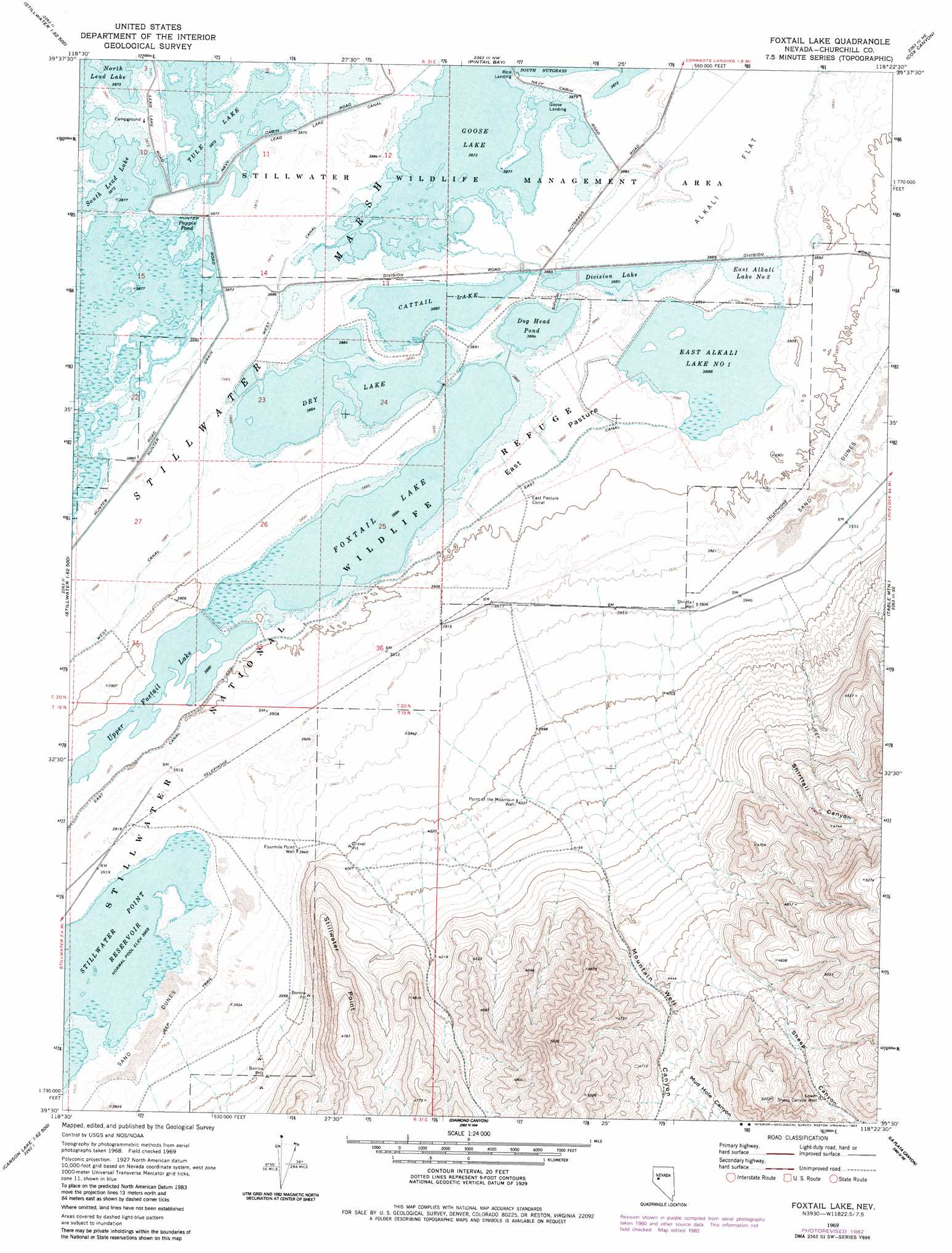
Foxtail Lake Topo Map Nevada
To zoom in, hover over the map of Foxtail Lake
USGS Topo Quad 39118e4 - 1:24,000 scale
| Topo Map Name: | Foxtail Lake |
| USGS Topo Quad ID: | 39118e4 |
| Print Size: | ca. 21 1/4" wide x 27" high |
| Southeast Coordinates: | 39.5° N latitude / 118.375° W longitude |
| Map Center Coordinates: | 39.5625° N latitude / 118.4375° W longitude |
| U.S. State: | NV |
| Filename: | o39118e4.jpg |
| Download Map JPG Image: | Foxtail Lake topo map 1:24,000 scale |
| Map Type: | Topographic |
| Topo Series: | 7.5´ |
| Map Scale: | 1:24,000 |
| Source of Map Images: | United States Geological Survey (USGS) |
| Alternate Map Versions: |
Foxtail Lake NV 1969, updated 1972 Download PDF Buy paper map Foxtail Lake NV 1969, updated 1983 Download PDF Buy paper map Foxtail Lake NV 2011 Download PDF Buy paper map Foxtail Lake NV 2015 Download PDF Buy paper map |
1:24,000 Topo Quads surrounding Foxtail Lake
Carson Sink Sw |
Carson Sink Se |
Lone Rock Sw |
Lone Rock Se |
Fondaway Canyon |
Battleground Point |
Stillwater Ne |
Pintail Bay |
Cox Canyon |
I X L Canyon |
Indian Lakes |
Stillwater |
Foxtail Lake |
Table Mountain |
Job Peak |
Grimes Point |
Lahontan Mountains |
Diamond Canyon |
La Plata Canyon |
Pirouette Mountain |
Carson Lake |
Bunejug Mountains |
Fourmile Flat |
Frenchman |
Drumm Summit |
> Back to 39118e1 at 1:100,000 scale
> Back to 39118a1 at 1:250,000 scale
> Back to U.S. Topo Maps home
Foxtail Lake topo map: Gazetteer
Foxtail Lake: Canals
East Canal elevation 1188m 3897′Goose Lake Bypass elevation 1184m 3884′
Hunter Drain elevation 1184m 3884′
Lead Lake Canal elevation 1182m 3877′
West Canal elevation 1185m 3887′
Foxtail Lake: Cliffs
Stillwater Point elevation 1389m 4557′Foxtail Lake: Dams
Stillwater Point Dam elevation 1191m 3907′Foxtail Lake: Flats
East Pasture elevation 1187m 3894′West Pasture elevation 1185m 3887′
Foxtail Lake: Parks
Stillwater National Wildlife Refuge elevation 1190m 3904′Foxtail Lake: Reservoirs
Cattail Lake elevation 1184m 3884′Division Lake elevation 1184m 3884′
Dog Head Pond elevation 1185m 3887′
Dry Lake elevation 1184m 3884′
East Alkali Lake Number One elevation 1186m 3891′
East Alkali Lake Number Two elevation 1184m 3884′
Foxtail Lake elevation 1185m 3887′
Pappis Pond elevation 1182m 3877′
South Lead Lake elevation 1182m 3877′
Stillwater Point Reservoir elevation 1191m 3907′
Upper Foxtail Lake elevation 1186m 3891′
Foxtail Lake: Swamps
Stillwater Marsh elevation 1181m 3874′Foxtail Lake: Valleys
Mountain Well Canyon elevation 1242m 4074′Mud Hole Canyon elevation 1360m 4461′
Sheep Canyon elevation 1285m 4215′
Shirttail Canyon elevation 1218m 3996′
Foxtail Lake: Wells
Fourmile Point Well elevation 1201m 3940′Lower Sheep Canyon Well elevation 1494m 4901′
Point of the Mountain Well elevation 1230m 4035′
Shirttail Well elevation 1201m 3940′
West Ripley Canyon Well elevation 1214m 3982′
Foxtail Lake digital topo map on disk
Buy this Foxtail Lake topo map showing relief, roads, GPS coordinates and other geographical features, as a high-resolution digital map file on DVD: